


$2,890
/ Month
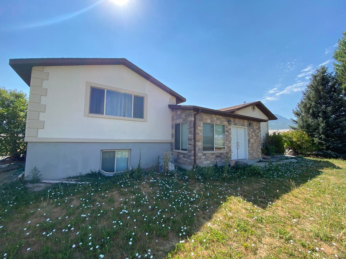
1235 S 1950 W
Payson, UT 84651
Favorites
801-235-7368
-
Bedrooms
5
-
Bathrooms
3
-
Square Feet
2,214 sq ft
-
Available
Available Now
1235 S 1950 W

Favorites
About This Home
$2,890 deposit,
Available Now
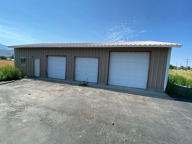
This large family home is located on 5 acres in Payson. Five bedroom, three bath including lots of common living space and a private office. Also includes a four car detached garage and a large detached workshop. Call today to schedule a showing at or apply online at rentals.amres.co. 6 month lease Rent: $2890 Deposit: $2890 NO SMOKING/VAPING
Unique Features
- 5 Acres
- Propane is used for gas
- White Dishwasher
- White Electric Stove/Oven
- White Refrigerator
1235 S 1950 W is a house located in Utah County and the 84651 ZIP Code.
* Price shown is base rent. Excludes user-selected optional fees and variable or usage-based fees and required charges due at or prior to move-in or at move-out. Price, availability, fees, and any applicable rent special are subject to change without notice.
* Square footage definitions vary. Displayed square footage is approximate.
Contact
- Listed by Advantage Management Partners LLC | Advantage Management Partners LLC
- Phone Number
- Contact
Location
Get Directions
Amenities
- 5 Acres
- Propane is used for gas
- White Dishwasher
- White Electric Stove/Oven
- White Refrigerator
Education
| Colleges & Universities | Distance | ||
|---|---|---|---|
| Colleges & Universities | Distance | ||
| Drive: | 19 min | 15.4 mi | |
| Drive: | 21 min | 16.0 mi | |
| Drive: | 25 min | 19.1 mi | |
| Drive: | 28 min | 22.4 mi |
1235 S 1950 W is within 19 minutes or 15.4 miles from Noorda College. It is also near Rocky Mountain University and Brigham Young University.
Getting Around
 What do Walkability, Transit, Drivability, and Bikeability mean?
Walkability measures the walking distance to day-to-day needs.
Transit measures access to public transportation.
Drivability measures congestion, parking availability, and access to major roads.
Bikeability measures the suitability for cycling.
How It Works
What do Walkability, Transit, Drivability, and Bikeability mean?
Walkability measures the walking distance to day-to-day needs.
Transit measures access to public transportation.
Drivability measures congestion, parking availability, and access to major roads.
Bikeability measures the suitability for cycling.
How It Works
Somewhat Walkable
Walkability
20
/ 100
Minimal Public Transit
Transit
0
/ 100
Exceptionally Drivable
Drivability
100
/ 100
Somewhat Bikeable
Bikeability
30
/ 100
Scores provided by
-
Soundscore™
-
/ 100
Traffic
-Airport
-Businesses
-Scores provided by
HowLoud What is a Sound Score Rating? A Sound Score Rating aggregates noise caused by vehicle traffic, airplane traffic and local sources. How It WorksYou May Also Like
Similar Rentals Nearby
-
-
 5 Beds$2,520Total Monthly PriceTotal Monthly Price NewPrices include all required monthly fees.House for Rent
 -
 4 Beds$2,480Total Monthly PriceTotal Monthly Price NewPrices include all required monthly fees.House for Rent
 -
 5 Beds$2,480Total Monthly PriceTotal Monthly Price NewPrices include all required monthly fees.House for Rent
 -
 5 Beds$2,775Total Monthly PriceTotal Monthly Price NewPrices include all required monthly fees.House for Rent
 -

-
 5 Beds$3,130Total Monthly PriceTotal Monthly Price NewPrices include all required monthly fees.House for Rent
 -
 4 Beds$2,495Total Monthly PriceTotal Monthly Price NewPrices include all required monthly fees.House for Rent
 -

-
 6 Beds$2,575Total Monthly PriceTotal Monthly Price NewPrices include all required monthly fees.House for Rent

What Are Walk Score®, Transit Score®, and Bike Score® Ratings?
Walk Score® measures the walkability of any address. Transit Score® measures access to public transit. Bike Score® measures the bikeability of any address.
What is a Sound Score Rating?
A Sound Score Rating aggregates noise caused by vehicle traffic, airplane traffic and local sources.

1235 S 1950 W
Payson, UT 84651