

$5,000
/ Month
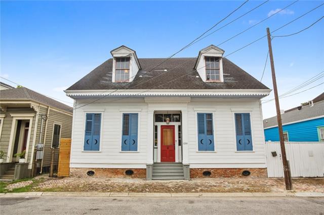
1233 Kerlerec St
New Orleans, LA 70116
Favorites
1233 Kerlerec St

Favorites
Check Back Soon for Upcoming Availability
| Beds | Baths | Average SF |
|---|---|---|
| 2 Bedrooms 2 Bedrooms 2 Br | 2 Baths 2 Baths 2 Ba | 2,100 SF |
About This Property
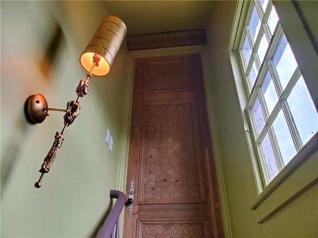
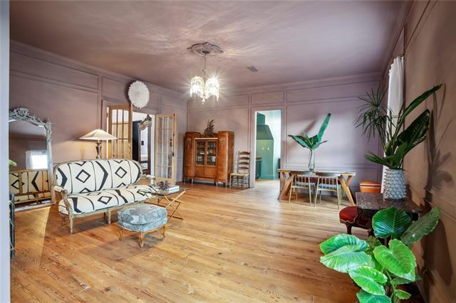
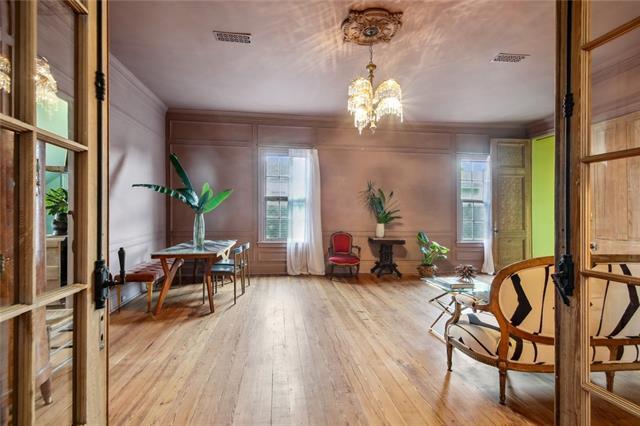
Breathtaking new renovation in the historic Treme, 1 block from Esplanade, 2 blocks from FQ. This stunning apt is fully furnished with beautifully restored antiques. High design decor includes custom drapery, one-of-a-kind chandeliers, luxurious bedding & more. Located on the 2nd floor of an historic center hall main house, this colorful, sprawling masterpiece boasts soaring ceilings, hardwood floors, art deco kitchen, spa-like bathrooms, & a romantic library for relaxing. In-unit Laundry. Pets considered.
1233 Kerlerec St is a townhome located in Orleans County and the 70116 ZIP Code. This area is served by the Orleans Parish School District attendance zone.
Townhome Features
- Island Kitchen
1233 Kerlerec St,
New Orleans,
LA
70116
Though the Seventh Ward is a bustling residential neighborhood, it’s known for being a peaceful area to put down roots. Residents appreciate its affordable housing and tree-lined streets, along with its unbeatable proximity to the French Quarter – the hub of all things New Orleans.
Though urban in population, the Seventh Ward boasts a charming suburban feel that gives its residents a peaceful reprieve from the hustle and bustle of New Orleans. Situated just off of the Mississippi River, the Seventh Ward is a prime spot to find an affordable rental in a great location.
If you’re hoping for a family-friendly vibe, then you’ll appreciate the neighborhood’s local gem, St. Augustine High School, known for its extracurricular activities. Entertainment surrounds this residential neighborhood.
Learn more about living in Seventh WardBelow are rent ranges for similar nearby apartments
Amenities
- Island Kitchen
Education
| Colleges & Universities | Distance | ||
|---|---|---|---|
| Colleges & Universities | Distance | ||
| Drive: | 3 min | 1.6 mi | |
| Drive: | 3 min | 1.6 mi | |
| Drive: | 6 min | 2.6 mi | |
| Drive: | 8 min | 4.4 mi |
1233 Kerlerec St is within 3 minutes or 1.6 miles from Tulane Univ., Health Ctr. It is also near LSU Health Center, Downtown and Dillard University.
Schools

Public Elementary & Middle School
Grades PK-8
697 Students
Attendance Zone
Public Elementary & Middle School
Grades PK-8
745 Students
Attendance Zone
Public Middle & High School
Grades 6-12
802 Students
Attendance Zone
Public High School
Grades 9-12
Attendance Zone
Public High School
Grades 9-12
990 Students
Attendance Zone
Private Elementary & Middle School
Grades PK-8
243 Students
Nearby
Private Elementary & Middle School
Grades PK-8
160 Students
Nearby
Private Elementary & Middle School
Grades K-8
Nearby
Private Middle & High School
Grades 6-12
Nearby
School data provided by
 The GreatSchools Rating helps parents compare schools within a state based on a variety of school quality indicators and provides a helpful picture of how effectively each school serves all of its students. Ratings are on a scale of 1 (below average) to 10 (above average) and can include test scores, college readiness, academic progress, advanced courses, equity, discipline and attendance data. We also advise parents to visit schools, consider other information on school performance and programs, and consider family needs as part of the school selection process.
View GreatSchools Rating Methodology
Data provided by GreatSchools.org © 2026. All rights reserved.
View GreatSchools Rating Methodology
Data provided by GreatSchools.org © 2026. All rights reserved.
Transportation options available in New Orleans include N. Rampart St. At Esplanade Ave., located 0.2 mile from 1233 Kerlerec St. 1233 Kerlerec St is near Louis Armstrong New Orleans International, located 14.8 miles or 23 minutes away.
| Transit / Subway | Distance | ||
|---|---|---|---|
| Transit / Subway | Distance | ||
| Walk: | 3 min | 0.2 mi | |
| Walk: | 5 min | 0.3 mi | |
| Walk: | 7 min | 0.4 mi | |
| Walk: | 8 min | 0.5 mi | |
| Walk: | 11 min | 0.6 mi |
| Commuter Rail | Distance | ||
|---|---|---|---|
| Commuter Rail | Distance | ||
|
|
Drive: | 5 min | 2.1 mi |
|
|
Drive: | 37 min | 30.6 mi |
| Airports | Distance | ||
|---|---|---|---|
| Airports | Distance | ||
|
Louis Armstrong New Orleans International
|
Drive: | 23 min | 14.8 mi |
Walkability Near 1233 Kerlerec St New Orleans, LA 70116
Getting Around
 What do Walkability, Transit, Drivability, and Bikeability mean?
Walkability measures the walking distance to day-to-day needs.
Transit measures access to public transportation.
Drivability measures congestion, parking availability, and access to major roads.
Bikeability measures the suitability for cycling.
How It Works
What do Walkability, Transit, Drivability, and Bikeability mean?
Walkability measures the walking distance to day-to-day needs.
Transit measures access to public transportation.
Drivability measures congestion, parking availability, and access to major roads.
Bikeability measures the suitability for cycling.
How It Works
Exceptionally Walkable
Walkability
90
/ 100
Some Public Transit
Transit
50
/ 100
Moderately Drivable
Drivability
60
/ 100
Exceptionally Bikeable
Bikeability
90
/ 100
Scores provided by
-
Soundscore™
-
/ 100
Traffic
-Airport
-Businesses
-Scores provided by
HowLoud What is a Sound Score Rating? A Sound Score Rating aggregates noise caused by vehicle traffic, airplane traffic and local sources. How It WorksTime and distance from 1233 Kerlerec St.
| Shopping Centers | Distance | ||
|---|---|---|---|
| Shopping Centers | Distance | ||
| Walk: | 14 min | 0.7 mi | |
| Drive: | 4 min | 1.3 mi | |
| Drive: | 5 min | 1.7 mi |
1233 Kerlerec St has 3 shopping centers within 1.7 miles, which is about a 5-minute drive. The miles and minutes will be for the farthest away property.
| Parks and Recreation | Distance | ||
|---|---|---|---|
| Parks and Recreation | Distance | ||
|
New Orleans Jazz National Historical Park
|
Drive: | 5 min | 1.3 mi |
|
Audubon Aquarium of the Americas
|
Drive: | 5 min | 2.4 mi |
|
Entergy IMAX Theatre
|
Drive: | 5 min | 2.4 mi |
|
New Orleans Botanical Garden
|
Drive: | 6 min | 2.4 mi |
|
Louisiana Children's Museum
|
Drive: | 6 min | 2.6 mi |
1233 Kerlerec St has 5 parks within 2.6 miles, including New Orleans Jazz National Historical Park, Audubon Aquarium of the Americas, and Entergy IMAX Theatre.
| Hospitals | Distance | ||
|---|---|---|---|
| Hospitals | Distance | ||
| Drive: | 3 min | 1.4 mi | |
| Drive: | 3 min | 1.6 mi | |
| Drive: | 6 min | 3.7 mi |
1233 Kerlerec St has 3 hospitals within 3.7 miles, the nearest is Tulane Medical Center which is 1.4 miles away and a 3 minute drive.
| Military Bases | Distance | ||
|---|---|---|---|
| Military Bases | Distance | ||
| Drive: | 14 min | 7.9 mi | |
| Drive: | 29 min | 17.2 mi | |
| Drive: | 78 min | 59.4 mi |
1233 Kerlerec St has 3 military bases within 59.4 miles, the nearest is New Orleans Naval Support which is 7.9 miles away and a 14 minute drive.
You May Also Like
Similar Rentals Nearby


What Are Walk Score®, Transit Score®, and Bike Score® Ratings?
Walk Score® measures the walkability of any address. Transit Score® measures access to public transit. Bike Score® measures the bikeability of any address.
What is a Sound Score Rating?
A Sound Score Rating aggregates noise caused by vehicle traffic, airplane traffic and local sources.
1233 Kerlerec St
New Orleans, LA 70116