
-
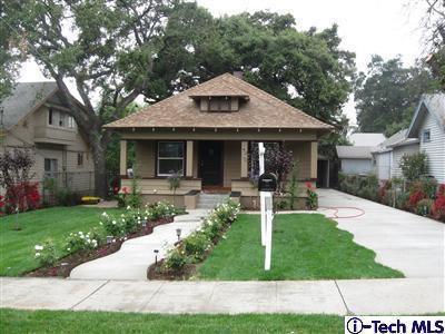
Front

-
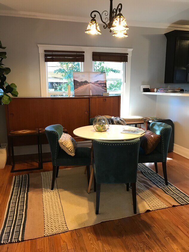
Dining room
-
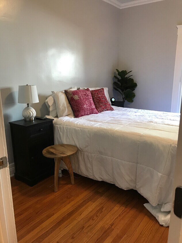
Bedroom
-
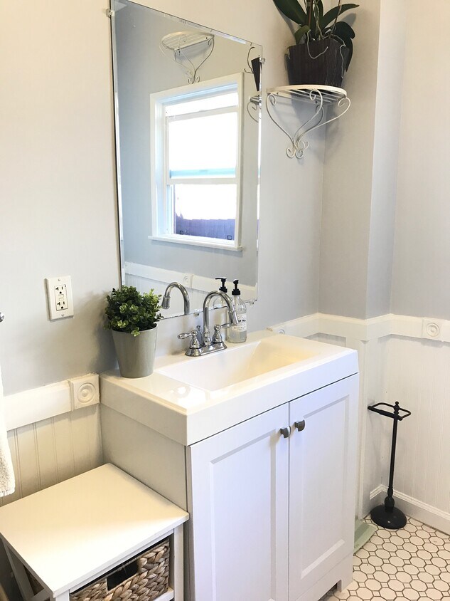
Bathroom
$3,500 / Month
1215 N Summit Ave
Pasadena, CA 91103
2 Weeks Ago
Favorites
1215 N Summit Ave

Favorites
Check Back Soon for Upcoming Availability
| Beds | Baths | Average SF |
|---|---|---|
| 2 Bedrooms 2 Bedrooms 2 Br | 1 Bath 1 Bath 1 Ba | 1,200 SF |
Fees and Policies
The fees below are based on community-supplied data and may exclude additional fees and utilities.
- Dogs Allowed
-
Fees not specified
- Cats Allowed
-
Fees not specified
- Parking
-
Surface Lot--
Details
Utilities Included
-
Water
-
Heat
-
Trash Removal
-
Sewer
-
Air Conditioning
About This Property
Beautifully remodeled two bed one bath Craftsman style house with old charm. Central air/heat keeps this charming house comfortable in the summer and winter. The kitchen has been updated with a modern twist while still maintaining the integrity of the time. The dining room and living room have refinished hardwood floors. Huge laundry room with new built-in cabinets and a 1/4 basement accessible from the backyard to finish off this charmer. Alarm system and front door digital locking system, for enhanced security. Open front yard and fenced side yard, great for small pets! A sizeable common yard between the two properties boasts a 100-year-old Oak tree, perfect for a swing! The owner pays for water, trash, gardening, and security alarm. One mile from Arroyo Seco Park and Old Town Pasadena. Respond fastest by text.
1215 N Summit Ave is a house located in Los Angeles County and the 91103 ZIP Code.
House Features
Washer/Dryer
Air Conditioning
Hardwood Floors
Tub/Shower
- Washer/Dryer
- Air Conditioning
- Heating
- Security System
- Storage Space
- Tub/Shower
- Sprinkler System
- Kitchen
- Hardwood Floors
- Dining Room
- Basement
- Laundry Facilities
- Yard
Location
Get Directions
Near the San Gabriel Mountains, where I-210 meets State Route 134 and becomes the Foothill Freeway, rests Pasadena’s Garfield Heights neighborhood. Primarily a residential area, Garfield Heights contains a number of markets, churches, and temples. Garfield Heights residents enjoy access to neighboring parks such as La Pintoresca Park and City of Pasadena Robinson Park.
There are a host of amenities located within close proximity to Garfield Heights. Among the many amenities are the Rose Bowl Stadium, Kidspace Children’s Museum, Norton Simon Museum, Brookside Golf and Country Club, Pasadena Convention Center, Paseo Colorado, and the California Institute of Technology.
Served by several Metro Local lines and Pasadena Transit routes, getting around Garfield Height is a breeze.
Learn more about living in Garfield HeightsBelow are rent ranges for similar nearby apartments
Amenities
- Washer/Dryer
- Air Conditioning
- Heating
- Security System
- Storage Space
- Tub/Shower
- Sprinkler System
- Kitchen
- Hardwood Floors
- Dining Room
- Basement
- Laundry Facilities
- Yard
Expenses
Utilities Included
Water, Heat, Trash Removal, Sewer, Air Conditioning
Included
Education
| Colleges & Universities | Distance | ||
|---|---|---|---|
| Colleges & Universities | Distance | ||
| Drive: | 4 min | 1.8 mi | |
| Drive: | 7 min | 3.2 mi | |
| Drive: | 8 min | 3.5 mi | |
| Drive: | 10 min | 3.5 mi |
1215 N Summit Ave is within 4 minutes or 1.8 miles from Fuller Theological Seminary. It is also near Art Center College of Design and Pasadena City College.
Transportation options available in Pasadena include Memorial Park Station, located 1.6 miles from 1215 N Summit Ave. 1215 N Summit Ave is near Bob Hope, located 17.4 miles or 24 minutes away, and Los Angeles International, located 25.9 miles or 42 minutes away.
| Transit / Subway | Distance | ||
|---|---|---|---|
| Transit / Subway | Distance | ||
|
|
Drive: | 4 min | 1.6 mi |
|
|
Drive: | 5 min | 2.0 mi |
|
|
Drive: | 4 min | 2.0 mi |
|
|
Drive: | 6 min | 2.6 mi |
|
|
Drive: | 5 min | 3.0 mi |
| Commuter Rail | Distance | ||
|---|---|---|---|
| Commuter Rail | Distance | ||
|
|
Drive: | 14 min | 9.9 mi |
|
|
Drive: | 19 min | 10.9 mi |
|
|
Drive: | 21 min | 10.9 mi |
|
|
Drive: | 21 min | 12.0 mi |
| Drive: | 23 min | 15.0 mi |
| Airports | Distance | ||
|---|---|---|---|
| Airports | Distance | ||
|
Bob Hope
|
Drive: | 24 min | 17.4 mi |
|
Los Angeles International
|
Drive: | 42 min | 25.9 mi |
Time and distance from 1215 N Summit Ave.
| Shopping Centers | Distance | ||
|---|---|---|---|
| Shopping Centers | Distance | ||
| Walk: | 2 min | 0.2 mi | |
| Walk: | 20 min | 1.0 mi | |
| Drive: | 3 min | 1.1 mi |
1215 N Summit Ave has 3 shopping centers within 1.1 miles, which is about a 3-minute walk. The miles and minutes will be for the farthest away property.
| Parks and Recreation | Distance | ||
|---|---|---|---|
| Parks and Recreation | Distance | ||
|
Kidspace Children's Museum
|
Drive: | 5 min | 1.9 mi |
|
Jet Propulsion Laboratory
|
Drive: | 4 min | 2.3 mi |
|
Eaton Canyon Nature Center
|
Drive: | 8 min | 3.7 mi |
|
Huntington Botanical Gardens
|
Drive: | 11 min | 4.6 mi |
|
Descanso Gardens
|
Drive: | 10 min | 5.7 mi |
1215 N Summit Ave has 5 parks within 5.7 miles, including Kidspace Children's Museum, Jet Propulsion Laboratory, and Eaton Canyon Nature Center.
| Hospitals | Distance | ||
|---|---|---|---|
| Hospitals | Distance | ||
| Drive: | 5 min | 2.4 mi | |
| Drive: | 9 min | 5.0 mi | |
| Drive: | 9 min | 5.7 mi |
1215 N Summit Ave has 3 hospitals within 5.7 miles, the nearest is Huntington Memorial Hospital which is 2.4 miles away and a 5 minute drive.
| Military Bases | Distance | ||
|---|---|---|---|
| Military Bases | Distance | ||
| Drive: | 39 min | 27.5 mi | |
| Drive: | 49 min | 31.0 mi |
1215 N Summit Ave is 27.5 miles from Los Angeles Air Force Base, and is convenient to other military bases, including Los Alamitos Army Airfield.
You May Also Like
Similar Rentals Nearby


What Are Walk Score®, Transit Score®, and Bike Score® Ratings?
Walk Score® measures the walkability of any address. Transit Score® measures access to public transit. Bike Score® measures the bikeability of any address.
What is a Sound Score Rating?
A Sound Score Rating aggregates noise caused by vehicle traffic, airplane traffic and local sources
1215 N Summit Ave
Pasadena, CA 91103