

$2,000
/ Month
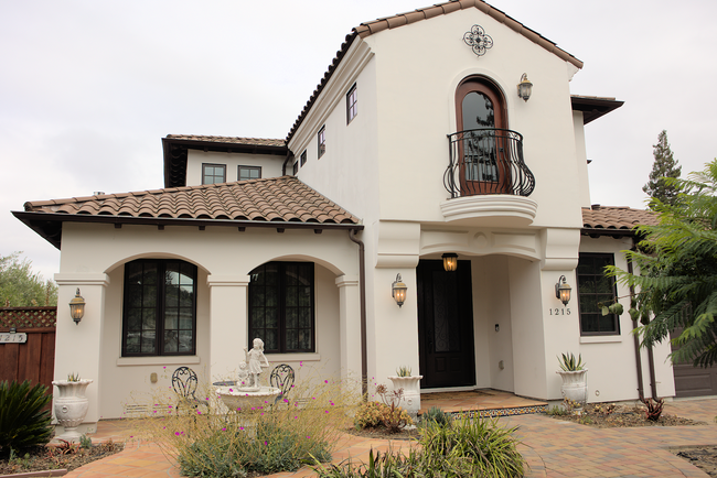
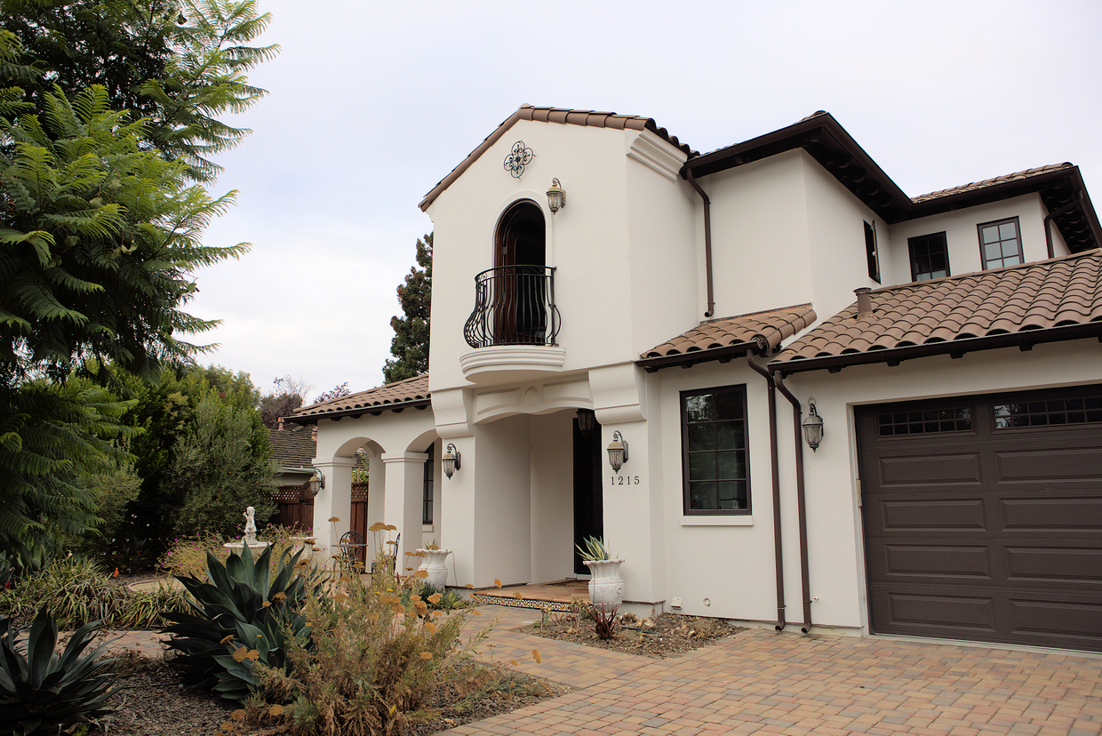
1215 Altamead Dr
Los Altos, CA 94024
2 Weeks Ago
|
Edit
Favorites
1215 Altamead Dr

Favorites
Check Back Soon for Upcoming Availability
| Beds | Baths | Average SF |
|---|---|---|
| 1 Bedroom 1 Bedroom 1 Br | 1 Bath 1 Bath 1 Ba | 300 SF |
About This Property
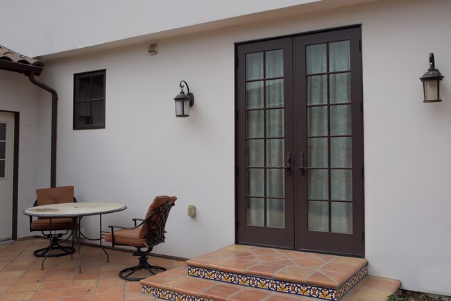
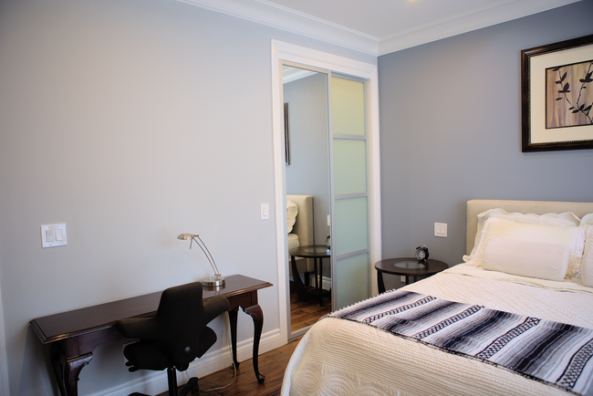
A master suite in a beautiful newly built spanish style house It locates near all major tech companies: google, Meta, and Apple. It is within 5 min drive distance to El Camino Hospital, grocery stores and restaurants. It features: -private entrance -private bathroom -washer/dryer in the unit -fully furnished w a queen bed -refrigerator/microwave in the suite -renter can use outdoor kitchen -spacious backyard with fire pit one occupant only please Short term monthly lease (minimum one month ) is welcome Short term rent (less than 6 months) $2000 + $2000 security deposit per month include all utilities and internet Long term (greater than 12 months) $1800 + $1800 security deposit include all utilities and internet Available June 9, 2024
1215 Altamead Dr is a house located in Santa Clara County and the 94024 ZIP Code. This area is served by the Los Altos Elementary School District attendance zone.
House Features
- Washer/Dryer
- Washer/Dryer Hookup
1215 Altamead Dr,
Los Altos,
CA
94024
Apricot orchards once blanketed the land where Los Altos now sits, and that quiet, unhurried character still shapes the city today. Tucked along the western edge of Silicon Valley in Santa Clara County, this small city spans just seven square miles yet packs in tree-lined streets, well-kept parks, and a genuinely walkable downtown along Main Street. Nearby Palo Alto and Mountain View are just minutes away, putting the best of the South Bay right at your doorstep without sacrificing the calm of a close-knit residential community. Redwood Grove Nature Preserve offers a shady escape when the pace of life calls for a reset.
The rental market here reflects the city's polished, residential feel. Apartment communities tend toward thoughtfully designed mid-size buildings and garden-style layouts, with townhomes also available for those wanting more space.
Learn more about living in Los AltosBelow are rent ranges for similar nearby apartments
Amenities
- Washer/Dryer
- Washer/Dryer Hookup
Education
| Colleges & Universities | Distance | ||
|---|---|---|---|
| Colleges & Universities | Distance | ||
| Drive: | 9 min | 3.6 mi | |
| Drive: | 10 min | 4.6 mi | |
| Drive: | 12 min | 6.1 mi | |
| Drive: | 18 min | 8.0 mi |
1215 Altamead Dr is within 9 minutes or 3.6 miles from Foothill Coll., Los Altos. It is also near De Anza College and Foothill College, Middlefield.
Schools


Public Elementary School
Grades K-5
407 Students
Nearby
Public Elementary School
Grades K-5
334 Students
Attendance Zone
Public Middle School
Grades 6-8
388 Students
Attendance Zone
Public High School
Grades 9-12
2,187 Students
Attendance Zone
Private Elementary & Middle School
Grades K-8
100 Students
Nearby
Private High School
Grades 9-12
1,745 Students
Nearby
School data provided by
 The GreatSchools Rating helps parents compare schools within a state based on a variety of school quality indicators and provides a helpful picture of how effectively each school serves all of its students. Ratings are on a scale of 1 (below average) to 10 (above average) and can include test scores, college readiness, academic progress, advanced courses, equity, discipline and attendance data. We also advise parents to visit schools, consider other information on school performance and programs, and consider family needs as part of the school selection process.
View GreatSchools Rating Methodology
Data provided by GreatSchools.org © 2026. All rights reserved.
View GreatSchools Rating Methodology
Data provided by GreatSchools.org © 2026. All rights reserved.
Transportation options available in Los Altos include Mountain View Station, located 2.8 miles from 1215 Altamead Dr. 1215 Altamead Dr is near Norman Y Mineta San Jose International, located 10.8 miles or 17 minutes away, and San Francisco International, located 27.9 miles or 36 minutes away.
| Transit / Subway | Distance | ||
|---|---|---|---|
| Transit / Subway | Distance | ||
| Drive: | 7 min | 2.8 mi | |
|
|
Drive: | 7 min | 3.0 mi |
|
|
Drive: | 7 min | 3.3 mi |
| Drive: | 8 min | 4.1 mi | |
| Drive: | 9 min | 5.0 mi |
| Commuter Rail | Distance | ||
|---|---|---|---|
| Commuter Rail | Distance | ||
| Drive: | 7 min | 2.6 mi | |
| Drive: | 9 min | 4.2 mi | |
| Drive: | 10 min | 4.3 mi | |
| Drive: | 16 min | 6.8 mi | |
| Drive: | 13 min | 7.7 mi |
| Airports | Distance | ||
|---|---|---|---|
| Airports | Distance | ||
|
Norman Y Mineta San Jose International
|
Drive: | 17 min | 10.8 mi |
|
San Francisco International
|
Drive: | 36 min | 27.9 mi |
Walkability Near 1215 Altamead Dr Los Altos, CA 94024
Getting Around
 What do Walkability, Transit, Drivability, and Bikeability mean?
Walkability measures the walking distance to day-to-day needs.
Transit measures access to public transportation.
Drivability measures congestion, parking availability, and access to major roads.
Bikeability measures the suitability for cycling.
How It Works
What do Walkability, Transit, Drivability, and Bikeability mean?
Walkability measures the walking distance to day-to-day needs.
Transit measures access to public transportation.
Drivability measures congestion, parking availability, and access to major roads.
Bikeability measures the suitability for cycling.
How It Works
Fairly Walkable
Walkability
50
/ 100
Limited Public Transit
Transit
30
/ 100
Very Drivable
Drivability
80
/ 100
Fairly Bikeable
Bikeability
50
/ 100
Scores provided by
-
Soundscore™
-
/ 100
Traffic
-Airport
-Businesses
-Scores provided by
HowLoud What is a Sound Score Rating? A Sound Score Rating aggregates noise caused by vehicle traffic, airplane traffic and local sources. How It WorksTime and distance from 1215 Altamead Dr.
| Shopping Centers | Distance | ||
|---|---|---|---|
| Shopping Centers | Distance | ||
| Drive: | 3 min | 1.2 mi | |
| Drive: | 4 min | 1.3 mi | |
| Drive: | 4 min | 1.6 mi |
1215 Altamead Dr has 3 shopping centers within 1.6 miles, which is about a 4-minute drive. The miles and minutes will be for the farthest away property.
| Parks and Recreation | Distance | ||
|---|---|---|---|
| Parks and Recreation | Distance | ||
|
Redwood Grove
|
Drive: | 8 min | 3.0 mi |
|
Deer Hollow Farm
|
Drive: | 10 min | 3.7 mi |
|
Rancho San Antonio County Park
|
Drive: | 10 min | 3.9 mi |
|
Foothill College Observatory
|
Drive: | 10 min | 3.9 mi |
|
Rancho San Antonio Open Space Preserve
|
Drive: | 11 min | 3.9 mi |
1215 Altamead Dr has 5 parks within 3.9 miles, including Redwood Grove, Deer Hollow Farm, and Foothill College Observatory.
| Hospitals | Distance | ||
|---|---|---|---|
| Hospitals | Distance | ||
| Walk: | 11 min | 0.6 mi | |
| Drive: | 14 min | 6.4 mi | |
| Drive: | 13 min | 7.0 mi |
1215 Altamead Dr has 3 hospitals within 7.0 miles, the nearest is El Camino Hospital which is 0.6 mile away and a 11 minute walk.
| Military Bases | Distance | ||
|---|---|---|---|
| Military Bases | Distance | ||
| Drive: | 11 min | 4.9 mi |
1215 Altamead Dr is 4.9 miles and a 11 minute drive from Ames Research Center.
You May Also Like
Similar Rentals Nearby


What Are Walk Score®, Transit Score®, and Bike Score® Ratings?
Walk Score® measures the walkability of any address. Transit Score® measures access to public transit. Bike Score® measures the bikeability of any address.
What is a Sound Score Rating?
A Sound Score Rating aggregates noise caused by vehicle traffic, airplane traffic and local sources.
1215 Altamead Dr
Los Altos, CA 94024