

$9,500 / Month
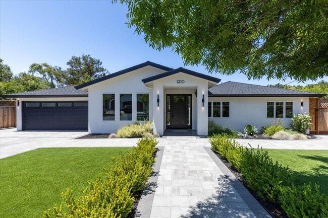
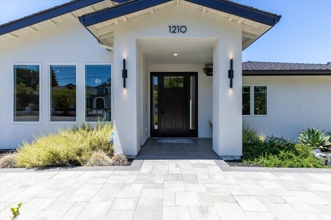
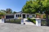
1210 Larnel Pl
Los Altos, CA 94024
Today
Favorites
-
Bedrooms
3
-
Bathrooms
2.5
-
Square Feet
2,275 sq ft
-
Available
Available Now
Highlight
- Fireplace
1210 Larnel Pl

Favorites
About This Home
Available Now
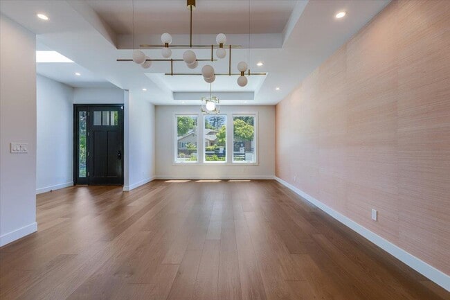
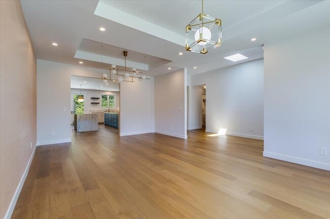
Exquisitely remodeled single-level ranch in a prime Los Altos neighborhood near the Country Club. This ~2,275 SF home blends clean contemporary design with timeless comfort on a beautifully landscaped 12,000 SF lot. The chefs kitchen features solid-surface waterfall countertops, dual islands, induction cooktop, wine fridge, 48 fridge/freezer, double ovens, and intimate banquet seating. French doors open to expansive patios, a sport court, large natural play area and low voltage evening lighting, ideal for indoor-outdoor lifestyle. Multiple living spaces include a family room with gas fireplace and a 65-inch TV, and a spacious combined living/dining area. The elegant primary suite boasts a custom walk-in closet and spa-like bath. Designer finishes include modern luxury bathrooms, chic grasscloth wallpaper, wide-plank floors, recessed lighting, and modern fixtures. The front yard includes a fragrant rose garden, always green faux turf. Tesla EV charger in a 2-car garage. Award winning public schools (tenant to verify enrollment). Please no pets (except service animals). 1-year lease min $9,500/month + Tenant pays utilities. Renters' insurance required. Weekly landscaping and professional management included. Applicants to pay $35 application fee and apply via Zillow rental app."
1210 Larnel Pl is a house located in Santa Clara County and the 94024 ZIP Code. This area is served by the Cupertino Union attendance zone.
* Price shown is base rent and may not include non-optional fees and utilities.
Price, availability, fees, and any applicable rent special are subject to change without notice.
* Square footage definitions vary. Displayed square footage is approximate.
House Features
- Fireplace
Fees and Policies
The fees below are based on community-supplied data and may exclude additional fees and utilities.
Contact
- Listed by Kristi Foxgrover | Christie's International Real Estate Sereno
- Contact
-
Source
 MLSListings Inc.
Copyright © 2025 MLSListings Inc.
Location
Get Directions
Amenities
- Fireplace
Los Altos likes to strike a balance between the urbanized atmosphere of the Bay Area and the more rural environment of the wide-open spaces bordering the city’s southwest side. While it is mainly a residential community, the downtown area surrounding Main Street is a walkable shopping and dining district with tree-lined streets and several public parks nearby. The crime rate is quite low and the local schools are among the highest-performing in the state. Palo Alto is right next door and San Jose just a few minutes down the road, giving Los Altos residents convenient access to Silicon Valley’s greatest amenities.
Learn more about living in Los Altos
Education
| Colleges & Universities | Distance | ||
|---|---|---|---|
| Colleges & Universities | Distance | ||
| Drive: | 8 min | 3.5 mi | |
| Drive: | 9 min | 3.8 mi | |
| Drive: | 13 min | 5.9 mi | |
| Drive: | 16 min | 7.8 mi |
1210 Larnel Pl is within 8 minutes or 3.5 miles from Foothill Coll., Los Altos. It is also near De Anza College and Foothill College, Middlefield.
Schools


Public Elementary School
Grades K-5
382 Students
Attendance Zone
Public Elementary School
Grades K-5
367 Students
Nearby
Public Middle School
Grades 6-8
1,099 Students
Attendance Zone
Public High School
Grades 9-12
2,311 Students
Attendance Zone
Private Elementary & Middle School
Grades PK-8
500 Students
Nearby
Private Elementary & Middle School
Grades PK-8
114 Students
Nearby
Private Elementary, Middle & High School
Grades K-12
26 Students
Nearby
School data provided by
 The GreatSchools Rating helps parents compare schools within a state based on a variety of school quality indicators and provides a helpful picture of how effectively each school serves all of its students. Ratings are on a scale of 1 (below average) to 10 (above average) and can include test scores, college readiness, academic progress, advanced courses, equity, discipline and attendance data. We also advise parents to visit schools, consider other information on school performance and programs, and consider family needs as part of the school selection process.
View GreatSchools Rating Methodology
Data provided by GreatSchools.org © 2025. All rights reserved.
View GreatSchools Rating Methodology
Data provided by GreatSchools.org © 2025. All rights reserved.
Transportation options available in Los Altos include Mountain View Station, located 3.6 miles from 1210 Larnel Pl. 1210 Larnel Pl is near Norman Y Mineta San Jose International, located 13.5 miles or 20 minutes away, and San Francisco International, located 30.1 miles or 40 minutes away.
| Transit / Subway | Distance | ||
|---|---|---|---|
| Transit / Subway | Distance | ||
| Drive: | 10 min | 3.6 mi | |
|
|
Drive: | 10 min | 3.6 mi |
| Drive: | 11 min | 4.4 mi | |
| Drive: | 11 min | 4.5 mi | |
| Drive: | 11 min | 4.7 mi |
| Commuter Rail | Distance | ||
|---|---|---|---|
| Commuter Rail | Distance | ||
| Drive: | 10 min | 3.5 mi | |
| Drive: | 11 min | 3.7 mi | |
| Drive: | 10 min | 4.9 mi | |
| Drive: | 13 min | 5.4 mi | |
| Drive: | 16 min | 7.2 mi |
| Airports | Distance | ||
|---|---|---|---|
| Airports | Distance | ||
|
Norman Y Mineta San Jose International
|
Drive: | 20 min | 13.5 mi |
|
San Francisco International
|
Drive: | 40 min | 30.1 mi |
Time and distance from 1210 Larnel Pl.
| Shopping Centers | Distance | ||
|---|---|---|---|
| Shopping Centers | Distance | ||
| Drive: | 3 min | 1.2 mi | |
| Drive: | 3 min | 1.4 mi | |
| Drive: | 5 min | 1.8 mi |
1210 Larnel Pl has 3 shopping centers within 1.8 miles, which is about a 5-minute drive. The miles and minutes will be for the farthest away property.
| Parks and Recreation | Distance | ||
|---|---|---|---|
| Parks and Recreation | Distance | ||
|
Redwood Grove
|
Drive: | 7 min | 2.9 mi |
|
Deer Hollow Farm
|
Drive: | 8 min | 3.0 mi |
|
Rancho San Antonio County Park
|
Drive: | 8 min | 3.1 mi |
|
McClellan Ranch Park
|
Drive: | 8 min | 3.4 mi |
|
Foothill College Observatory
|
Drive: | 9 min | 3.7 mi |
1210 Larnel Pl has 5 parks within 3.7 miles, including Deer Hollow Farm, Rancho San Antonio County Park, and Redwood Grove.
| Hospitals | Distance | ||
|---|---|---|---|
| Hospitals | Distance | ||
| Drive: | 6 min | 2.0 mi | |
| Drive: | 11 min | 6.2 mi | |
| Drive: | 11 min | 6.6 mi |
1210 Larnel Pl has 3 hospitals within 6.6 miles, the nearest is El Camino Hospital which is 2.0 miles away and a 6 minute drive.
| Military Bases | Distance | ||
|---|---|---|---|
| Military Bases | Distance | ||
| Drive: | 15 min | 7.1 mi |
1210 Larnel Pl is 7.1 miles and a 15 minute drive from Ames Research Center.
You May Also Like
Similar Rentals Nearby


What Are Walk Score®, Transit Score®, and Bike Score® Ratings?
Walk Score® measures the walkability of any address. Transit Score® measures access to public transit. Bike Score® measures the bikeability of any address.
What is a Sound Score Rating?
A Sound Score Rating aggregates noise caused by vehicle traffic, airplane traffic and local sources
1210 Larnel Pl
Los Altos, CA 94024