
$13,600
/ Month
121 Degas Rd
Portola Valley, CA 94028
Today
|
Edit
Favorites
-
Bedrooms
3
-
Bathrooms
2.5
-
Square Feet
2,850 sq ft
-
Available
Available Now
Highlights
- Private Pool
- Open to Family Room
- 2 Car Attached Garage
- Forced Air Zoned Heating and Cooling System
- Dining Area
- 1-Story Property
121 Degas Rd

Favorites
About This Home
Available Now
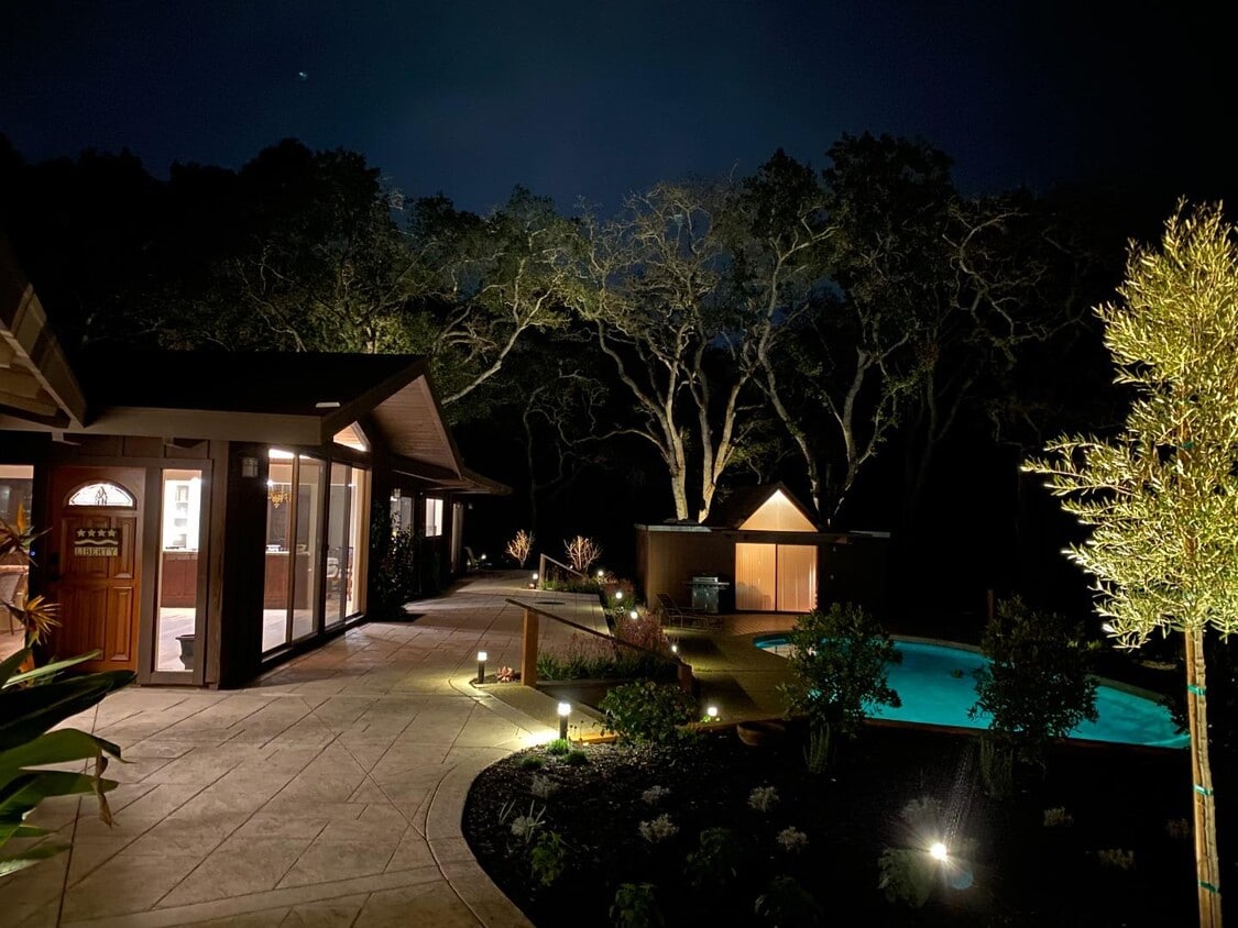
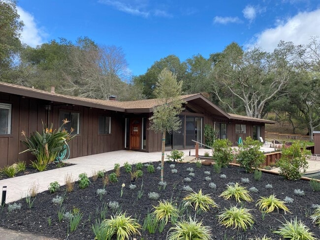
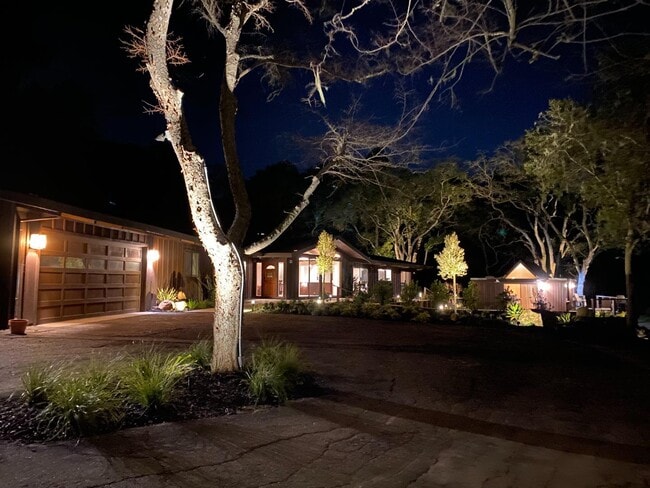
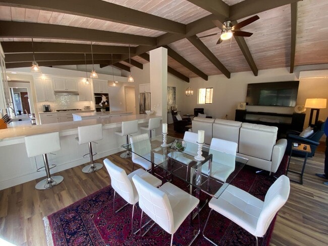
Tucked away on a quiet cul-de-sac in one of Portola Valleys most desirable neighborhoods, this inviting fully furnished home offers privacy, comfort, and a seamless connection to its natural surroundings. Thoughtfully designed with generous living spaces, the residence is filled with natural light and framed by serene views of mature trees and landscaped grounds. The main living areas flow effortlessly, creating an ideal setting for both everyday living and entertaining. Large windows bring the outdoors in, while well-proportioned rooms provide flexibility for a variety of lifestyles. The kitchen is functional and welcoming, offering ample storage and workspace, and opens naturally to the homes dining and living areas. Bedrooms are comfortably sized and positioned for privacy, making the home well-suited for families, professionals, or those seeking a peaceful retreat close to Silicon Valley. Outdoors, a sparkling swimming pool creates a resort-like atmosphereperfect for relaxing, entertaining, or enjoying Portola Valleys mild climate. Conveniently located near top-rated Portola Valley schools, scenic hiking and biking trails, and with easy access to Sandhill Road and Highway 280, this home offers the perfect balance of tranquility and accessibility.
121 Degas Rd is a house located in San Mateo County and the 94028 ZIP Code. This area is served by the Portola Valley Elementary attendance zone.
* Price shown is base rent. Excludes user-selected optional fees and variable or usage-based fees and required charges due at or prior to move-in or at move-out. Price, availability, fees, and any applicable rent special are subject to change without notice.
* Square footage definitions vary. Displayed square footage is approximate.
Home Details
Home Type
Single Family Detached Home
Bedrooms and Bathrooms
2.5 Bathrooms
3 Bedrooms
Interior Spaces
Living Room with Fireplace
Dining Area
2,850 Sq Ft Home
1-Story Property
Kitchen
Open to Family Room
Breakfast Bar
Listing and Financial Details
Security Deposit $13,600
Property Available on 12/30/25
12-Month Minimum Lease Term
Rent includes furniture, gardener, pool/spa
Lot Details
2.88 Acre Lot
Parking
2 Car Attached Garage
Pool
Private Pool
Utilities
Forced Air Zoned Heating and Cooling System
Community Details
Contact
- Listed by Kavanaugh Group | Coldwell Banker Realty
- Contact
-
Source
 MLSListings Inc.
Copyright © 2025 MLSListings Inc.
Location
Get Directions
Amenities
- Fireplace
- Pool
Education
| Colleges & Universities | Distance | ||
|---|---|---|---|
| Colleges & Universities | Distance | ||
| Drive: | 15 min | 5.4 mi | |
| Drive: | 17 min | 6.2 mi | |
| Drive: | 14 min | 7.4 mi | |
| Drive: | 15 min | 8.1 mi |
121 Degas Rd is within 15 minutes or 5.4 miles from Stanford University. It is also near Menlo College and Foothill Coll., Los Altos.
Schools


Public Elementary School
Grades K-3
240 Students
Attendance Zone
Public Elementary & Middle School
Grades 4-8
273 Students
Attendance Zone
Public Elementary School
Grades K-5
367 Students
Nearby
Public High School
Grades 9-12
1,694 Students
Attendance Zone
Private Elementary & Middle School
Grades PK-8
266 Students
Nearby
Private Middle & High School
Grades 6-12
397 Students
Nearby
School data provided by
 The GreatSchools Rating helps parents compare schools within a state based on a variety of school quality indicators and provides a helpful picture of how effectively each school serves all of its students. Ratings are on a scale of 1 (below average) to 10 (above average) and can include test scores, college readiness, academic progress, advanced courses, equity, discipline and attendance data. We also advise parents to visit schools, consider other information on school performance and programs, and consider family needs as part of the school selection process.
View GreatSchools Rating Methodology
Data provided by GreatSchools.org © 2026. All rights reserved.
View GreatSchools Rating Methodology
Data provided by GreatSchools.org © 2026. All rights reserved.
Transportation options available in Portola Valley include Mountain View Station, located 10.5 miles from 121 Degas Rd. 121 Degas Rd is near Norman Y Mineta San Jose International, located 23.0 miles or 33 minutes away, and San Francisco International, located 24.3 miles or 37 minutes away.
| Transit / Subway | Distance | ||
|---|---|---|---|
| Transit / Subway | Distance | ||
| Drive: | 23 min | 10.5 mi | |
|
|
Drive: | 23 min | 10.5 mi |
|
|
Drive: | 26 min | 12.8 mi |
|
|
Drive: | 26 min | 13.1 mi |
| Drive: | 26 min | 14.4 mi |
| Commuter Rail | Distance | ||
|---|---|---|---|
| Commuter Rail | Distance | ||
| Drive: | 15 min | 6.0 mi | |
| Drive: | 16 min | 6.5 mi | |
| Drive: | 17 min | 7.8 mi | |
| Drive: | 17 min | 8.1 mi | |
| Drive: | 20 min | 8.9 mi |
| Airports | Distance | ||
|---|---|---|---|
| Airports | Distance | ||
|
Norman Y Mineta San Jose International
|
Drive: | 33 min | 23.0 mi |
|
San Francisco International
|
Drive: | 37 min | 24.3 mi |
Time and distance from 121 Degas Rd.
| Shopping Centers | Distance | ||
|---|---|---|---|
| Shopping Centers | Distance | ||
| Drive: | 8 min | 2.5 mi | |
| Drive: | 9 min | 2.6 mi | |
| Drive: | 10 min | 3.9 mi |
121 Degas Rd has 3 shopping centers within 3.9 miles, which is about a 10-minute drive. The miles and minutes will be for the farthest away property.
| Parks and Recreation | Distance | ||
|---|---|---|---|
| Parks and Recreation | Distance | ||
|
Pearson-Arastradero Regional Preserve
|
Drive: | 7 min | 2.2 mi |
|
Stanford Hills Park
|
Drive: | 10 min | 4.0 mi |
|
Sharon Park
|
Drive: | 11 min | 4.7 mi |
|
Jasper Ridge Biological Preserve
|
Drive: | 17 min | 6.1 mi |
|
Thornewood Open Space Preserve
|
Drive: | 21 min | 7.1 mi |
121 Degas Rd has 5 parks within 7.1 miles, including Pearson-Arastradero Regional Preserve, Stanford Hills Park, and Sharon Park.
| Hospitals | Distance | ||
|---|---|---|---|
| Hospitals | Distance | ||
| Drive: | 11 min | 4.6 mi | |
| Drive: | 12 min | 4.8 mi | |
| Drive: | 20 min | 12.0 mi |
121 Degas Rd has 3 hospitals within 12.0 miles, the nearest is Stanford Health Care which is 4.6 miles away and a 11 minute drive.
| Military Bases | Distance | ||
|---|---|---|---|
| Military Bases | Distance | ||
| Drive: | 29 min | 14.8 mi |
121 Degas Rd is 14.8 miles and a 29 minute drive from Ames Research Center.
You May Also Like
Similar Rentals Nearby


What Are Walk Score®, Transit Score®, and Bike Score® Ratings?
Walk Score® measures the walkability of any address. Transit Score® measures access to public transit. Bike Score® measures the bikeability of any address.
What is a Sound Score Rating?
A Sound Score Rating aggregates noise caused by vehicle traffic, airplane traffic and local sources

121 Degas Rd
Portola Valley, CA 94028