
$3,500 / Month
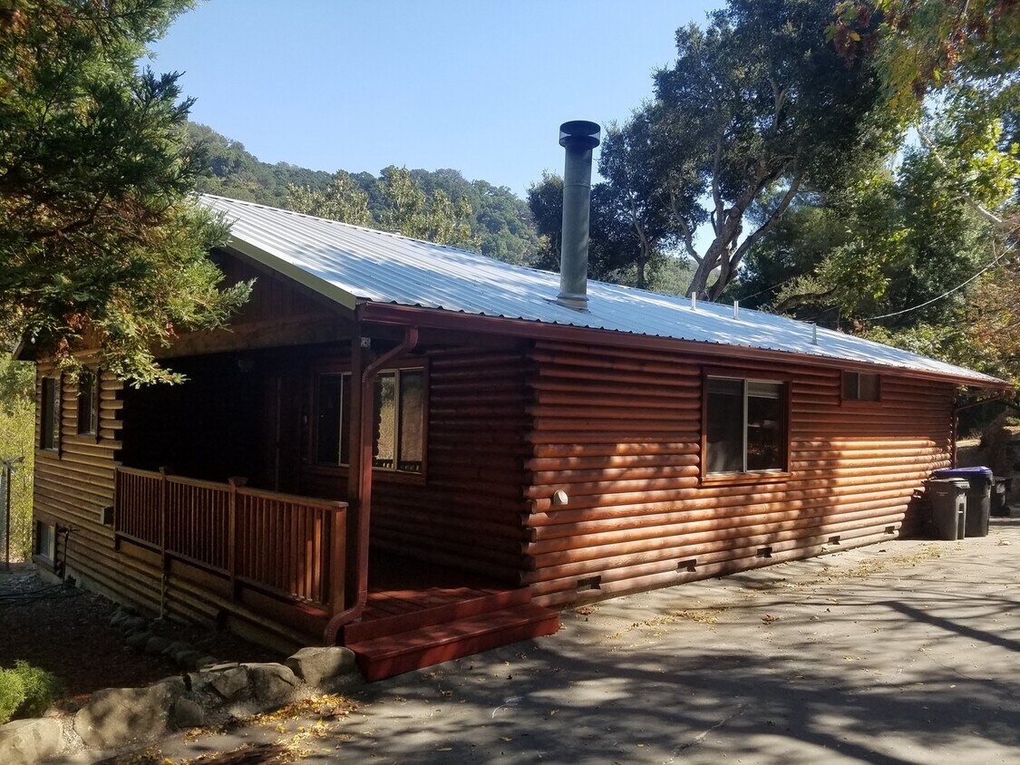
12045 Glenora Way
Sunol, CA 94586
Today
Favorites
925-259-3939
-
Bedrooms
2
-
Bathrooms
2
-
Square Feet
1,465 sq ft
-
Available
Available Now
12045 Glenora Way

Favorites
About This Home
$3,500 deposit,
Available Now
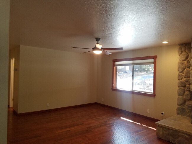
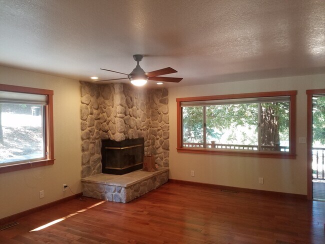
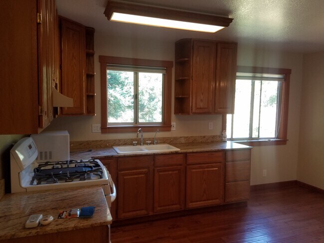
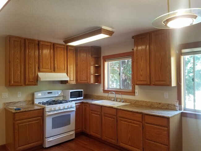
Experience tranquil living in this spacious 2-bedroom, 2-bath log cabin nestled in the picturesque hills of Sunol Valley. This charming home features solid flooring throughout and a warm, inviting family room with a striking corner fireplace—perfect for cozy nights in. The kitchen offers generous counter space, an eat-in area, and easy flow for everyday living. A finished basement provides added versatility—ideal for a home office, playroom, or additional storage. Step outside and enjoy a serene community with access to a sparkling pool, clubhouse, and playground. Located in an excellent school district, and just steps away from scenic trails for hiking, biking, and running. Pet: One cat ok with additional deposit
12045 Glenora Way is a house located in Alameda County and the 94586 ZIP Code. This area is served by the San Ramon Valley Unified attendance zone.
* Price shown is base rent and may not include non-optional fees and utilities.
Price, availability, fees, and any applicable rent special are subject to change without notice.
* Square footage definitions vary. Displayed square footage is approximate.
Contact
- Listed by Blue Sapphire Homes Inc. | Blue Sapphire Homes Inc.
- Phone Number
- Contact
Location
Get Directions
The cities of Livermore, Dublin and Pleasanton form a loosely shaped triangle within California's Tri-Valley region, a cluster of three small valleys about 33 miles east of San Francisco and 35 miles northeast of San Jose. Known for its Mediterranean climate, rolling hills and historic vineyards, this once bucolic region now boasts three separate downtown areas, a bustling business community and some of the best wineries in the state.
At the eastern end of the region lies the city of Livermore. Once known as Livermores, Livermore Ranch and Nottingham, the city sits at the center of Livermore Valley, a historic region dotted with more than 5,000 acres of mostly family-owned vineyards. A pastoral neighborhood known for its charming yet functional hilltop windmills, Livermore hosts the internationally recognized and sometimes controversial center of scientific research, Lawrence Livermore National Laboratories.
Learn more about living in Dublin/Pleasanton/Livermore
Education
| Colleges & Universities | Distance | ||
|---|---|---|---|
| Colleges & Universities | Distance | ||
| Drive: | 24 min | 10.2 mi | |
| Drive: | 34 min | 16.1 mi | |
| Drive: | 34 min | 16.9 mi | |
| Drive: | 39 min | 18.0 mi |
12045 Glenora Way is within 24 minutes or 10.2 miles from Ohlone College, Fremont Campus. It is also near Diablo Valley Coll, San Ramon and Las Positas College.
Schools


Public Elementary School
Grades K-5
497 Students
Nearby
Public Elementary & Middle School
Grades K-8
268 Students
Attendance Zone
Public High School
Grades 9-12
2,199 Students
Nearby
Private Elementary, Middle & High School
Grades K-12
23 Students
Nearby
Private Elementary School
Grades PK-5
Nearby
School data provided by
 The GreatSchools Rating helps parents compare schools within a state based on a variety of school quality indicators and provides a helpful picture of how effectively each school serves all of its students. Ratings are on a scale of 1 (below average) to 10 (above average) and can include test scores, college readiness, academic progress, advanced courses, equity, discipline and attendance data. We also advise parents to visit schools, consider other information on school performance and programs, and consider family needs as part of the school selection process.
View GreatSchools Rating Methodology
Data provided by GreatSchools.org © 2025. All rights reserved.
View GreatSchools Rating Methodology
Data provided by GreatSchools.org © 2025. All rights reserved.
Transportation options available in Sunol include Fremont, located 11.2 miles from 12045 Glenora Way. 12045 Glenora Way is near Norman Y Mineta San Jose International, located 25.1 miles or 41 minutes away, and Metro Oakland International, located 31.1 miles or 48 minutes away.
| Transit / Subway | Distance | ||
|---|---|---|---|
| Transit / Subway | Distance | ||
|
|
Drive: | 28 min | 11.2 mi |
|
|
Drive: | 28 min | 11.6 mi |
|
|
Drive: | 25 min | 12.6 mi |
|
|
Drive: | 30 min | 13.1 mi |
|
|
Drive: | 26 min | 13.3 mi |
| Commuter Rail | Distance | ||
|---|---|---|---|
| Commuter Rail | Distance | ||
| Drive: | 23 min | 9.9 mi | |
| Drive: | 23 min | 10.0 mi | |
| Drive: | 29 min | 12.3 mi | |
| Drive: | 29 min | 12.4 mi | |
| Drive: | 32 min | 15.4 mi |
| Airports | Distance | ||
|---|---|---|---|
| Airports | Distance | ||
|
Norman Y Mineta San Jose International
|
Drive: | 41 min | 25.1 mi |
|
Metro Oakland International
|
Drive: | 48 min | 31.1 mi |
Time and distance from 12045 Glenora Way.
| Shopping Centers | Distance | ||
|---|---|---|---|
| Shopping Centers | Distance | ||
| Drive: | 21 min | 8.3 mi | |
| Drive: | 21 min | 9.1 mi | |
| Drive: | 22 min | 9.1 mi |
12045 Glenora Way has 3 shopping centers within 9.1 miles, which is about a 22-minute drive. The miles and minutes will be for the farthest away property.
| Parks and Recreation | Distance | ||
|---|---|---|---|
| Parks and Recreation | Distance | ||
|
Niles Canyon Railway
|
Drive: | 24 min | 10.2 mi |
|
Niles Community Park
|
Drive: | 26 min | 10.7 mi |
|
Shadow Cliffs Regional Recreation Area
|
Drive: | 29 min | 11.2 mi |
|
Garin/Dry Creek Pioneer Parks
|
Drive: | 30 min | 13.6 mi |
|
Pleasanton Ridge Regional Park
|
Drive: | 37 min | 13.6 mi |
12045 Glenora Way has 5 parks within 13.6 miles, including Niles Canyon Railway, Niles Community Park, and Shadow Cliffs Regional Recreation Area.
| Hospitals | Distance | ||
|---|---|---|---|
| Hospitals | Distance | ||
| Drive: | 26 min | 11.2 mi | |
| Drive: | 28 min | 11.3 mi | |
| Drive: | 27 min | 12.8 mi |
12045 Glenora Way has 3 hospitals within 12.8 miles, the nearest is Washington Hospital which is 11.2 miles away and a 26 minute drive.
| Military Bases | Distance | ||
|---|---|---|---|
| Military Bases | Distance | ||
| Drive: | 47 min | 27.9 mi |
12045 Glenora Way is 27.9 miles and a 47 minute drive from Ames Research Center.
You May Also Like
Similar Rentals Nearby


What Are Walk Score®, Transit Score®, and Bike Score® Ratings?
Walk Score® measures the walkability of any address. Transit Score® measures access to public transit. Bike Score® measures the bikeability of any address.
What is a Sound Score Rating?
A Sound Score Rating aggregates noise caused by vehicle traffic, airplane traffic and local sources

12045 Glenora Way
Sunol, CA 94586