

$1,995
Total Monthly Price
118 Perou St Unit 518
Perris, CA 92570
Favorites
-
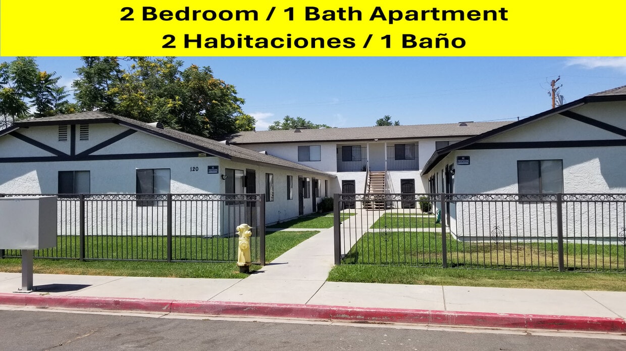
Bedrooms
2
-
Bathrooms
1
-
Square Feet
1,400 sq ft
-
Available
Available Now
118 Perou St Unit 518

Favorites
About This Home
12 Month Lease,
$1,995 deposit,
Available Now
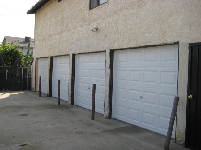
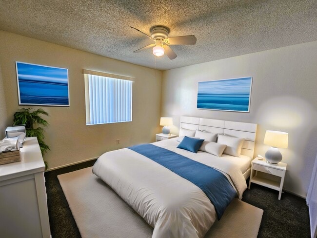
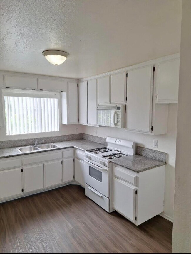
Welcome to this charming 2-bedroom, 1-bath apartment located in a quiet, family-friendly neighborhood in Perris, California. This well-maintained unit offers a comfortable and inviting living space perfect for small families, couples, or working professionals. Enjoy the convenience of a separate private garage, providing extra storage and parking while maintaining added privacy from the main unit. The apartment also features a dedicated laundry room for added convenience and everyday comfort. Located in a peaceful neighborhood, this home is ideal for those looking for a calm and relaxed environment. With spacious bedrooms, a functional layout, and a welcoming atmosphere, this apartment is a great place to call home. Conveniently located near schools, parks, shopping, and major commuter routes. Don’t miss this opportunity to live in a quiet and friendly community in the heart of Perris.
118 Perou St is an apartment community located in Riverside County and the 92570 ZIP Code. This area is served by the Perris Union High School District attendance zone.
* Price shown is total price based on community-supplied monthly required fees. Excludes user-selected optional fees and variable or usage-based fees and required charges due at or prior to move-in or at move-out. Price, availability, fees, and any applicable rent special are subject to change without notice.
* Square footage definitions vary. Displayed square footage is approximate.
Apartment Features
- Laundry Facilities
Contact
- Contact
Location
Get Directions
Perris sits in the heart of Riverside County as part of the Inland Empire, about 70 miles southeast of Los Angeles, carrying a railroad history that dates to 1885 when the California Southern Railroad first put it on the map. The city covers roughly 32 square miles with a population just over 80,000, giving it a suburban scale where open land and developed neighborhoods coexist within easy reach of one another. Key economic anchors include retail, healthcare, and logistics, while March Air Reserve Base just north of the city adds a steady employment presence. Downtown Perris offers a walkable cluster of shops and local eateries, while North Perris leans toward quieter residential streets lined with schools and parks. Lake Perris State Recreation Area draws outdoor enthusiasts year-round, and the Southern California Railway Museum keeps the city's founding legacy alive.
Learn more about living in Perris
Education
| Colleges & Universities | Distance | ||
|---|---|---|---|
| Colleges & Universities | Distance | ||
| Drive: | 17 min | 9.3 mi | |
| Drive: | 14 min | 9.4 mi | |
| Drive: | 24 min | 16.6 mi | |
| Drive: | 32 min | 19.8 mi |
118 Perou St Unit 518 is within 17 minutes or 9.3 miles from Moreno Valley College. It is also near Mt San Jacinto Coll., Menifee and UC Riverside.
Schools


Public Elementary School
Grades K-5
617 Students
Attendance Zone
Public Middle School
Grades 6-8
952 Students
Attendance Zone
Public High School
Grades 9-12
2,096 Students
Attendance Zone
Private Elementary, Middle & High School
Grades K-12
Nearby
Private Elementary & Middle School
Grades PK-8
111 Students
Nearby
School data provided by
 The GreatSchools Rating helps parents compare schools within a state based on a variety of school quality indicators and provides a helpful picture of how effectively each school serves all of its students. Ratings are on a scale of 1 (below average) to 10 (above average) and can include test scores, college readiness, academic progress, advanced courses, equity, discipline and attendance data. We also advise parents to visit schools, consider other information on school performance and programs, and consider family needs as part of the school selection process.
View GreatSchools Rating Methodology
Data provided by GreatSchools.org © 2026. All rights reserved.
View GreatSchools Rating Methodology
Data provided by GreatSchools.org © 2026. All rights reserved.
Getting Around
 What do Walkability, Transit, Drivability, and Bikeability mean?
Walkability measures the walking distance to day-to-day needs.
Transit measures access to public transportation.
Drivability measures congestion, parking availability, and access to major roads.
Bikeability measures the suitability for cycling.
How It Works
What do Walkability, Transit, Drivability, and Bikeability mean?
Walkability measures the walking distance to day-to-day needs.
Transit measures access to public transportation.
Drivability measures congestion, parking availability, and access to major roads.
Bikeability measures the suitability for cycling.
How It Works
Fairly Walkable
Walkability
40
/ 100
Some Public Transit
Transit
50
/ 100
Exceptionally Drivable
Drivability
90
/ 100
Somewhat Bikeable
Bikeability
30
/ 100
Scores provided by
-
Soundscore™
-
/ 100
Traffic
-Airport
-Businesses
-Scores provided by
HowLoud What is a Sound Score Rating? A Sound Score Rating aggregates noise caused by vehicle traffic, airplane traffic and local sources. How It Works
Amenities
- Laundry Facilities
118 Perou St Unit 518 Photos
What Are Walk Score®, Transit Score®, and Bike Score® Ratings?
Walk Score® measures the walkability of any address. Transit Score® measures access to public transit. Bike Score® measures the bikeability of any address.
What is a Sound Score Rating?
A Sound Score Rating aggregates noise caused by vehicle traffic, airplane traffic and local sources.
118 Perou St
Perris, CA 92570