
$2,000 / Month
117 California Ave
Palo Alto, CA 94306
Today
Favorites
619-436-5352
-
Bedrooms
1
-
Bathrooms
1
-
Square Feet
728 sq ft
-
Available
Available Jul 22
117 California Ave

Favorites
About This Home
Available Jul 22
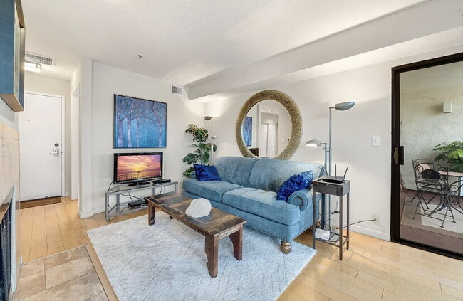
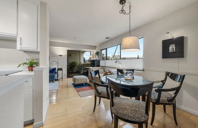
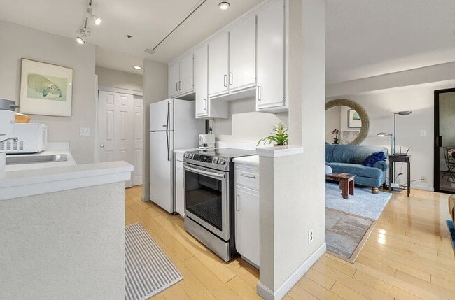
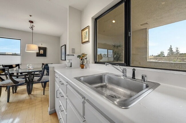
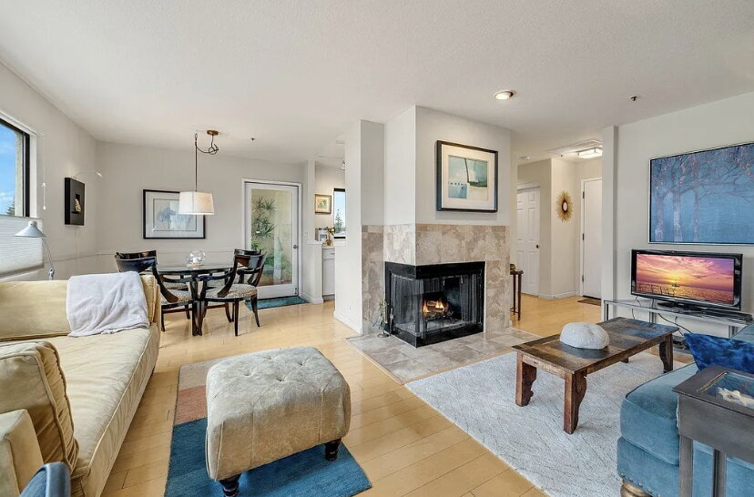
Move in and enjoy this amazingly located Palo Alto home overlooking California Avenue shops with views of Stanford University. This bright, beautiful and incredibly low maintenance home is peacefully perched above California Avenue with a secure elevator and secure stair access. Tastefully updated and meticulously maintained. Great views from the kitchen, dining area, living room, bedroom and both decks. Spacious bedroom. Lovely kitchen overlooking the deck. Inside laundry. Huge double-pane windows. Gleaming wood floors. Two large decks with great views. One reserved parking garage spot near elevator and additional garage parking. Short walking distance to Caltrain, Mollie Stones grocery store, fantastic restaurants and cafes along California Avenue, farmer's market, Stanford University and much more. Convenient commute location with easy access to Caltrain, Oregon Expressway, El Camino Real, Highway 280 and I-101. Wow.
117 California Ave is an apartment community located in Santa Clara County and the 94306 ZIP Code.
* Price shown is base rent and may not include non-optional fees and utilities.
Price, availability, fees, and any applicable rent special are subject to change without notice.
* Square footage definitions vary. Displayed square footage is approximate.
Features
Air Conditioning
Dishwasher
Washer/Dryer Hookup
Microwave
- Washer/Dryer Hookup
- Air Conditioning
- Ceiling Fans
- Fireplace
- Dishwasher
- Disposal
- Microwave
- Refrigerator
- Furnished
- Window Coverings
- Laundry Facilities
- Patio
Fees and Policies
The fees below are based on community-supplied data and may exclude additional fees and utilities.
Details
Property Information
-
Furnished Units Available
Contact
- Listed by Galen Property LLC
- Phone Number
- Contact
Location
Get Directions
Amenities
- Washer/Dryer Hookup
- Air Conditioning
- Ceiling Fans
- Fireplace
- Dishwasher
- Disposal
- Microwave
- Refrigerator
- Furnished
- Window Coverings
- Laundry Facilities
- Patio
Bordering the campus of the renowned Stanford University, Evergreen Park is a diverse, trendy neighborhood in Palo Alto. This upscale Bay Area community offers a variety of high-end apartments and condos available for rent. Evergreen Park is best known for its dynamic dining scene. Tech professionals, families, and college students flock to the neighborhood’s eclectic coffee shops, laid-back cafes, and more. Along with housing several government and corporate offices, Evergreen Park also houses salons, spas, medical offices, an art gallery, and two parks.
For even more dining, shopping, and entertainment options, Downtown Palo Alto is only a 10-minute drive away. Evergreen Park is also within proximity to small startups and major industry leaders in Silicon Valley including Google and Amazon.
Learn more about living in Evergreen Park
Education
| Colleges & Universities | Distance | ||
|---|---|---|---|
| Colleges & Universities | Distance | ||
| Drive: | 5 min | 1.8 mi | |
| Drive: | 9 min | 3.1 mi | |
| Drive: | 10 min | 4.0 mi | |
| Drive: | 13 min | 7.1 mi |
117 California Ave is within 5 minutes or 1.8 miles from Stanford University. It is also near Foothill College, Middlefield and Menlo College.
Transportation options available in Palo Alto include Mountain View Station, located 4.6 miles from 117 California Ave. 117 California Ave is near Norman Y Mineta San Jose International, located 14.9 miles or 22 minutes away, and San Francisco International, located 22.7 miles or 31 minutes away.
| Transit / Subway | Distance | ||
|---|---|---|---|
| Transit / Subway | Distance | ||
| Drive: | 10 min | 4.6 mi | |
|
|
Drive: | 10 min | 4.7 mi |
|
|
Drive: | 13 min | 5.9 mi |
| Drive: | 12 min | 7.3 mi | |
|
|
Drive: | 12 min | 7.4 mi |
| Commuter Rail | Distance | ||
|---|---|---|---|
| Commuter Rail | Distance | ||
| Walk: | 1 min | 0.1 mi | |
| Walk: | 4 min | 0.2 mi | |
| Drive: | 6 min | 2.2 mi | |
| Drive: | 8 min | 3.2 mi | |
| Drive: | 8 min | 3.4 mi |
| Airports | Distance | ||
|---|---|---|---|
| Airports | Distance | ||
|
Norman Y Mineta San Jose International
|
Drive: | 22 min | 14.9 mi |
|
San Francisco International
|
Drive: | 31 min | 22.7 mi |
Time and distance from 117 California Ave.
| Shopping Centers | Distance | ||
|---|---|---|---|
| Shopping Centers | Distance | ||
| Drive: | 4 min | 1.6 mi | |
| Drive: | 4 min | 1.6 mi | |
| Drive: | 6 min | 2.4 mi |
117 California Ave has 3 shopping centers within 2.4 miles, which is about a 6-minute drive. The miles and minutes will be for the farthest away property.
| Parks and Recreation | Distance | ||
|---|---|---|---|
| Parks and Recreation | Distance | ||
|
Gamble Garden
|
Drive: | 4 min | 1.6 mi |
|
Bol Park
|
Drive: | 4 min | 1.7 mi |
|
Junior Museum and Zoo
|
Drive: | 5 min | 2.0 mi |
|
Rinconada Park
|
Drive: | 6 min | 2.1 mi |
|
J. Pearce Mitchell Park
|
Drive: | 7 min | 2.4 mi |
117 California Ave has 5 parks within 2.4 miles, including Gamble Garden, Junior Museum and Zoo, and Rinconada Park.
| Hospitals | Distance | ||
|---|---|---|---|
| Hospitals | Distance | ||
| Drive: | 6 min | 2.5 mi | |
| Drive: | 8 min | 3.0 mi | |
| Drive: | 14 min | 6.1 mi |
117 California Ave has 3 hospitals within 6.1 miles, the nearest is Lucile Salter Packard Children's Hospital at Stanford which is 2.5 miles away and a 6 minute drive.
| Military Bases | Distance | ||
|---|---|---|---|
| Military Bases | Distance | ||
| Drive: | 15 min | 7.7 mi |
117 California Ave is 7.7 miles and a 15 minute drive from Ames Research Center.
You May Also Like
Similar Rentals Nearby


What Are Walk Score®, Transit Score®, and Bike Score® Ratings?
Walk Score® measures the walkability of any address. Transit Score® measures access to public transit. Bike Score® measures the bikeability of any address.
What is a Sound Score Rating?
A Sound Score Rating aggregates noise caused by vehicle traffic, airplane traffic and local sources
117 California Ave
Palo Alto, CA 94306