

$3,500
/ Month
116 Colorado Ave
Palo Alto, CA 94301
2 Weeks Ago
|
Edit
Favorites
116 Colorado Ave

Favorites
Check Back Soon for Upcoming Availability
| Beds | Baths | Average SF |
|---|---|---|
| 2 Bedrooms 2 Bedrooms 2 Br | 1 Bath 1 Bath 1 Ba | 770 SF |
About This Property
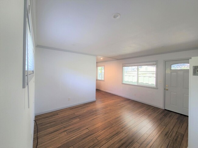
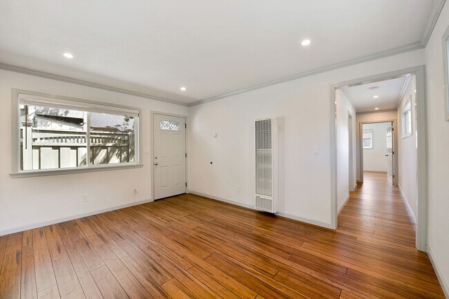
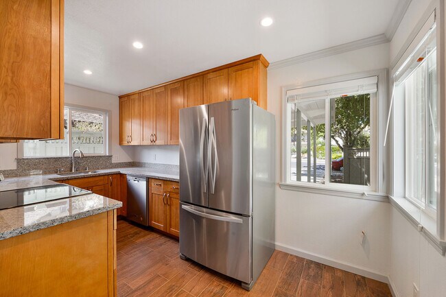
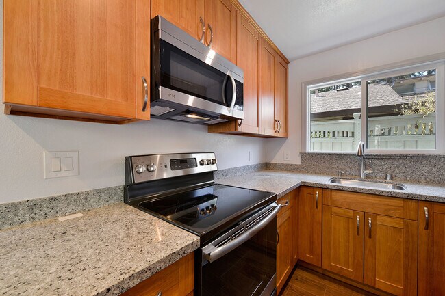
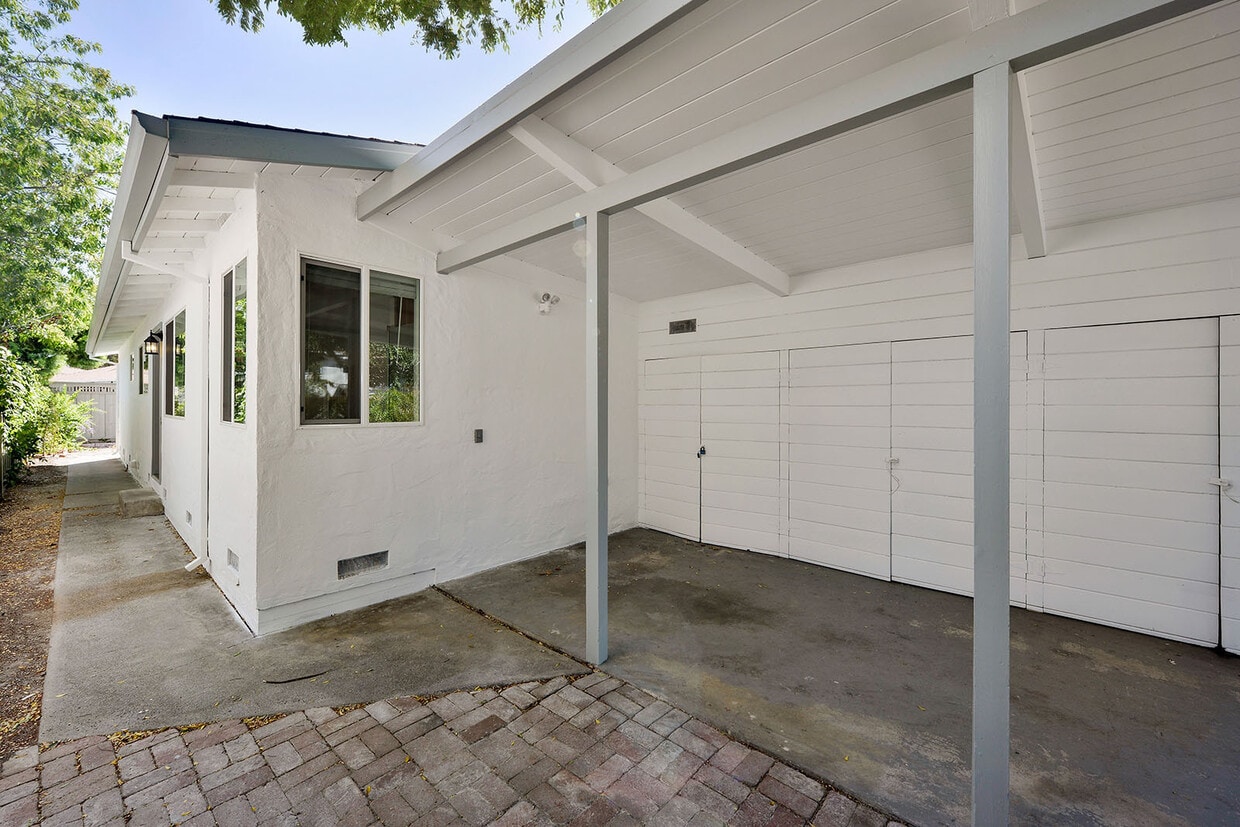
Renovated 2 Bedroom 1 Bathroom House in Midtown Palo Alto. This one story home features new laminate flooring, and new windows throughout. The kitchen has new granite counter-tops, and new stainless steel appliances including microwave and dishwasher. The home is about 770 square feet with washer and dryer, carport parking, and external storage in the carport. Palo Alto School District : El Carmelo Elementary School, Jane Lathrop Stanford Middle School, Palo Alto High School (tenant to verify) No Pets, No Smoking 3-D Tour Available Here (Copy and Paste into Browser): Minimum 12 month lease term. Applicants are subject to credit and background screening. This property is professionally managed by Wilbur Properties. All Wilbur Properties tenants will need to go through an application process. Each application is $50 per person over the age of 18. Please be aware of the following tenant criteria prior to setting up an appointment: 1. A credit score of greater than 700 2. Gross household income of three (3) times or greater than the asking rent 3. Landlord reference(s) 4. Employment verification(s) This property is professionally managed by Wilbur Properties. DRE#00823559
116 Colorado Ave is a house located in Santa Clara County and the 94301 ZIP Code. This area is served by the Palo Alto Unified School District attendance zone.
116 Colorado Ave,
Palo Alto,
CA
94301
Located along the San Francisco Bay, Palo Alto is one of the state's top-rated cities. Home to a variety of high-tech companies and only about a block from Stanford University, Midtown Palo Alto is a great neighborhood. Midtown features a shopping district along Middlefield Road and three large parks: Hoover Park, Henry Seale Park, and Greer Park. Midtown is a walkable neighborhood close to the Palo Alto Junior Museum and Zoo, Stanford Stadium, the Palo Alto Golf Course, and the Palo Alto Airport.
Learn more about living in Midtown Palo AltoBelow are rent ranges for similar nearby apartments
Education
| Colleges & Universities | Distance | ||
|---|---|---|---|
| Colleges & Universities | Distance | ||
| Drive: | 6 min | 2.4 mi | |
| Drive: | 7 min | 2.5 mi | |
| Drive: | 10 min | 4.2 mi | |
| Drive: | 13 min | 7.2 mi |
116 Colorado Ave is within 6 minutes or 2.4 miles from Stanford University. It is also near Foothill College, Middlefield and Menlo College.
Schools


Public Elementary School
Grades K-5
407 Students
Nearby
Public Elementary School
Grades K-5
282 Students
Attendance Zone
Public Middle School
Grades 6-8
1,002 Students
Attendance Zone
Public High School
Grades 9-12
1,891 Students
Attendance Zone
Private Elementary, Middle & High School
Grades K-12
72 Students
Nearby
Private Elementary School
Grades PK-5
58 Students
Nearby
School data provided by
 The GreatSchools Rating helps parents compare schools within a state based on a variety of school quality indicators and provides a helpful picture of how effectively each school serves all of its students. Ratings are on a scale of 1 (below average) to 10 (above average) and can include test scores, college readiness, academic progress, advanced courses, equity, discipline and attendance data. We also advise parents to visit schools, consider other information on school performance and programs, and consider family needs as part of the school selection process.
View GreatSchools Rating Methodology
Data provided by GreatSchools.org © 2026. All rights reserved.
View GreatSchools Rating Methodology
Data provided by GreatSchools.org © 2026. All rights reserved.
Transportation options available in Palo Alto include Mountain View Station, located 4.1 miles from 116 Colorado Ave. 116 Colorado Ave is near Norman Y Mineta San Jose International, located 14.4 miles or 20 minutes away, and San Francisco International, located 22.3 miles or 30 minutes away.
| Transit / Subway | Distance | ||
|---|---|---|---|
| Transit / Subway | Distance | ||
| Drive: | 8 min | 4.1 mi | |
|
|
Drive: | 11 min | 5.4 mi |
| Drive: | 10 min | 6.8 mi | |
|
|
Drive: | 12 min | 7.5 mi |
| Drive: | 12 min | 7.8 mi |
| Commuter Rail | Distance | ||
|---|---|---|---|
| Commuter Rail | Distance | ||
| Walk: | 6 min | 0.4 mi | |
| Drive: | 5 min | 2.0 mi | |
| Drive: | 6 min | 2.7 mi | |
| Drive: | 8 min | 3.4 mi | |
| Drive: | 11 min | 4.6 mi |
| Airports | Distance | ||
|---|---|---|---|
| Airports | Distance | ||
|
Norman Y Mineta San Jose International
|
Drive: | 20 min | 14.4 mi |
|
San Francisco International
|
Drive: | 30 min | 22.3 mi |
Walkability Near 116 Colorado Ave Palo Alto, CA 94301
Getting Around
 What do Walkability, Transit, Drivability, and Bikeability mean?
Walkability measures the walking distance to day-to-day needs.
Transit measures access to public transportation.
Drivability measures congestion, parking availability, and access to major roads.
Bikeability measures the suitability for cycling.
How It Works
What do Walkability, Transit, Drivability, and Bikeability mean?
Walkability measures the walking distance to day-to-day needs.
Transit measures access to public transportation.
Drivability measures congestion, parking availability, and access to major roads.
Bikeability measures the suitability for cycling.
How It Works
Moderately Walkable
Walkability
60
/ 100
Good Public Transit
Transit
70
/ 100
Moderately Drivable
Drivability
70
/ 100
Moderately Bikeable
Bikeability
70
/ 100
Scores provided by
-
Soundscore™
-
/ 100
Traffic
-Airport
-Businesses
-Scores provided by
HowLoud What is a Sound Score Rating? A Sound Score Rating aggregates noise caused by vehicle traffic, airplane traffic and local sources. How It WorksTime and distance from 116 Colorado Ave.
| Shopping Centers | Distance | ||
|---|---|---|---|
| Shopping Centers | Distance | ||
| Walk: | 19 min | 1.0 mi | |
| Drive: | 4 min | 1.7 mi | |
| Drive: | 5 min | 1.9 mi |
116 Colorado Ave has 3 shopping centers within 1.9 miles, which is about a 5-minute drive. The miles and minutes will be for the farthest away property.
| Parks and Recreation | Distance | ||
|---|---|---|---|
| Parks and Recreation | Distance | ||
|
Gamble Garden
|
Drive: | 3 min | 1.3 mi |
|
Junior Museum and Zoo
|
Drive: | 4 min | 1.6 mi |
|
Rinconada Park
|
Drive: | 4 min | 1.7 mi |
|
Bol Park
|
Drive: | 4 min | 1.8 mi |
|
J. Pearce Mitchell Park
|
Drive: | 5 min | 1.9 mi |
116 Colorado Ave has 5 parks within 1.9 miles, including Gamble Garden, Junior Museum and Zoo, and Rinconada Park.
| Hospitals | Distance | ||
|---|---|---|---|
| Hospitals | Distance | ||
| Drive: | 7 min | 2.7 mi | |
| Drive: | 8 min | 3.2 mi | |
| Drive: | 13 min | 8.4 mi |
116 Colorado Ave has 3 hospitals within 8.4 miles, the nearest is Lucile Salter Packard Children's Hospital at Stanford which is 2.7 miles away and a 7 minute drive.
| Military Bases | Distance | ||
|---|---|---|---|
| Military Bases | Distance | ||
| Drive: | 14 min | 7.3 mi |
116 Colorado Ave is 7.3 miles and a 14 minute drive from Ames Research Center.
You May Also Like
Similar Rentals Nearby


What Are Walk Score®, Transit Score®, and Bike Score® Ratings?
Walk Score® measures the walkability of any address. Transit Score® measures access to public transit. Bike Score® measures the bikeability of any address.
What is a Sound Score Rating?
A Sound Score Rating aggregates noise caused by vehicle traffic, airplane traffic and local sources.
116 Colorado Ave
Palo Alto, CA 94301