$2,100
/ Month
11457 Lindenwood Ave
El Paso, TX 79936
2 Weeks Ago
|
Edit
Favorites
11457 Lindenwood Ave

Favorites
Check Back Soon for Upcoming Availability
| Beds | Baths | Average SF |
|---|---|---|
| 4 Bedrooms 4 Bedrooms 4 Br | 3 Baths 3 Baths 3 Ba | 2,650 SF |
Fees and Policies
The fees listed below are community-provided and may exclude utilities or add-ons. All payments are made directly to the property and are non-refundable unless otherwise specified.
- Dogs Allowed
-
Fees not specified
-
Weight limit--
-
Pet Limit--
About This Property
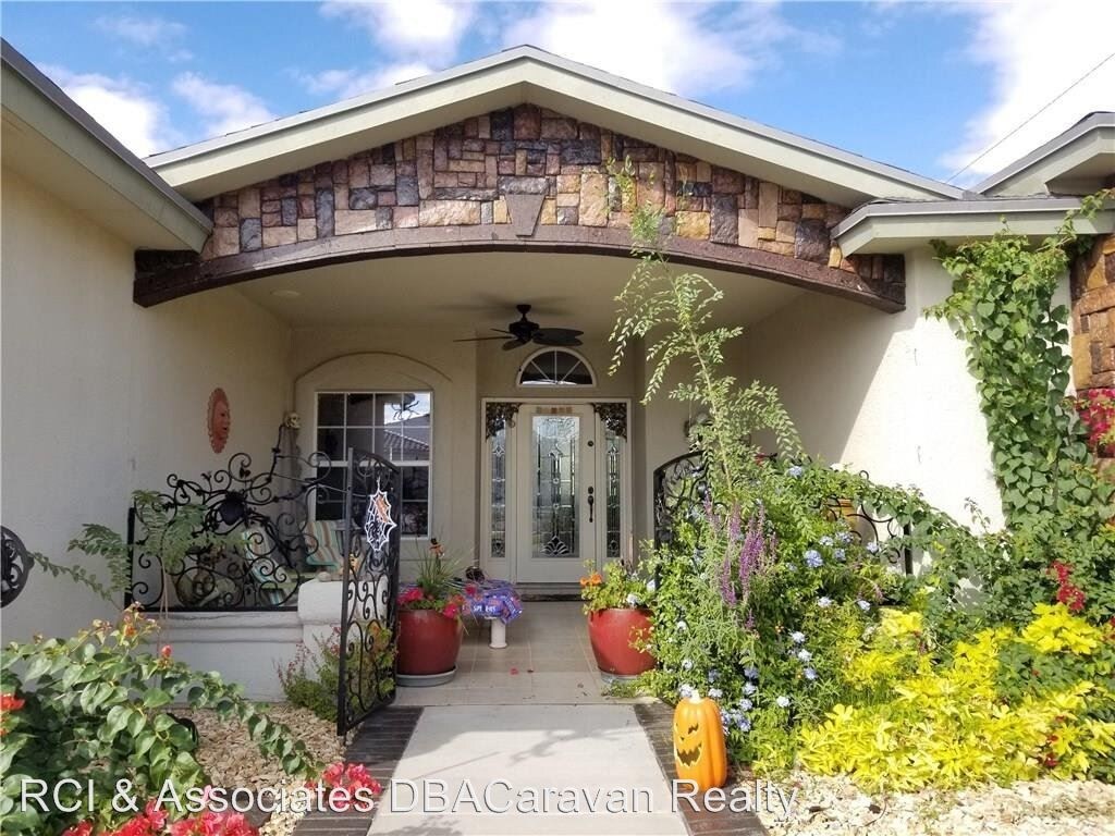
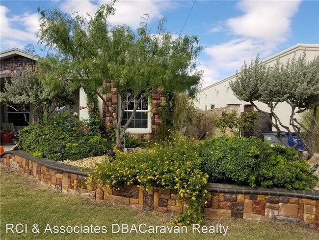
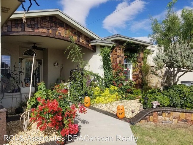
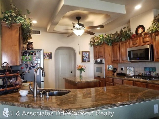
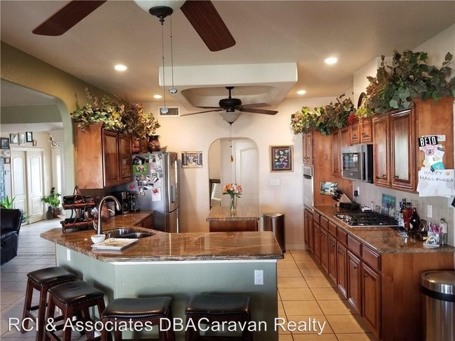
(915) 760-3193 - Executive Home for Lease - Truly exquisite Executive Home in desirable Kimberly Heights Subdivision! Custom privacy courtyard gates Welcome You to this well-designed Home. Features: Large "Zoned" Master Suite, with His and Hers walk-in closets, adjoining office, Master Bath, jetted tub, and double sinks. 3 Guest Bedrooms, 2 - ¾ bath, Generously sized Kitchen with Granite Countertops, Breakfast Area, Formal Dining, and Family Room. Interior and Exterior surround sound speakers, Custom Front and Backyard landscaping with Auto Sprinkler System. 3-car garage with RV Parking. Quick access to 375/Montana, Ft. Bliss, East Providence and etc... (RLNE4494615) Pet policies: Small Dogs Allowed, Cats Allowed.
11457 Lindenwood Ave is a house located in El Paso County and the 79936 ZIP Code. This area is served by the Socorro Independent School District attendance zone.
11457 Lindenwood Ave,
El Paso,
TX
79936
El Paso sits where West Texas, New Mexico, and the Mexican state of Chihuahua converge, giving the city a cross-border identity that shapes everything from its architecture to its daily rhythm. With the Franklin Mountains rising inside city limits and the Rio Grande forming its southern edge, the geography alone sets it apart from anywhere else in Texas. Fort Bliss, one of the largest U.S. Army installations in the country, and the University of Texas at El Paso are two of the city's most significant economic and institutional anchors. The Chamizal National Memorial marks the site of a peacefully resolved international border dispute, a piece of history few American cities can claim.
Neighborhoods range widely in character. Manhattan Heights offers historic homes close to downtown, while Northeast El Paso spreads out with newer residential development near Fort Bliss. Kern Place, adjacent to UTEP's campus, has an established, walkable feel.
Learn more about living in El PasoBelow are rent ranges for similar nearby apartments
Education
| Colleges & Universities | Distance | ||
|---|---|---|---|
| Colleges & Universities | Distance | ||
| Drive: | 14 min | 6.9 mi | |
| Drive: | 16 min | 9.8 mi | |
| Drive: | 20 min | 13.2 mi | |
| Drive: | 24 min | 15.0 mi |
11457 Lindenwood Ave is within 14 minutes or 6.9 miles from El Paso C.C., Valle Verde. It is also near El Paso C.C., Mission Del Paso and El Paso C.C., Rio Grande.
Schools


Public Elementary School
Grades PK-5
497 Students
Attendance Zone
Public Elementary & Middle School
Grades PK-8
829 Students
Nearby
Public Middle School
Grades 6-8
708 Students
Attendance Zone
Public High School
Grades 9-12
2,498 Students
Attendance Zone
Private Elementary, Middle & High School
Grades K-12
34 Students
Nearby
Private Elementary School
Grades PK-6
130 Students
Nearby
Private Elementary, Middle & High School
Grades K-12
79 Students
Nearby
School data provided by
 The GreatSchools Rating helps parents compare schools within a state based on a variety of school quality indicators and provides a helpful picture of how effectively each school serves all of its students. Ratings are on a scale of 1 (below average) to 10 (above average) and can include test scores, college readiness, academic progress, advanced courses, equity, discipline and attendance data. We also advise parents to visit schools, consider other information on school performance and programs, and consider family needs as part of the school selection process.
View GreatSchools Rating Methodology
Data provided by GreatSchools.org © 2026. All rights reserved.
View GreatSchools Rating Methodology
Data provided by GreatSchools.org © 2026. All rights reserved.
Walkability Near 11457 Lindenwood Ave El Paso, TX 79936
Getting Around
 What do Walkability, Transit, Drivability, and Bikeability mean?
Walkability measures the walking distance to day-to-day needs.
Transit measures access to public transportation.
Drivability measures congestion, parking availability, and access to major roads.
Bikeability measures the suitability for cycling.
How It Works
What do Walkability, Transit, Drivability, and Bikeability mean?
Walkability measures the walking distance to day-to-day needs.
Transit measures access to public transportation.
Drivability measures congestion, parking availability, and access to major roads.
Bikeability measures the suitability for cycling.
How It Works
Fairly Walkable
Walkability
40
/ 100
Limited Public Transit
Transit
20
/ 100
Moderately Drivable
Drivability
70
/ 100
Fairly Bikeable
Bikeability
40
/ 100
Scores provided by
-
Soundscore™
-
/ 100
Traffic
-Airport
-Businesses
-Scores provided by
HowLoud What is a Sound Score Rating? A Sound Score Rating aggregates noise caused by vehicle traffic, airplane traffic and local sources. How It WorksYou May Also Like
Similar Rentals Nearby


What Are Walk Score®, Transit Score®, and Bike Score® Ratings?
Walk Score® measures the walkability of any address. Transit Score® measures access to public transit. Bike Score® measures the bikeability of any address.
What is a Sound Score Rating?
A Sound Score Rating aggregates noise caused by vehicle traffic, airplane traffic and local sources.

11457 Lindenwood Ave
El Paso, TX 79936