

$1,100
/ Month
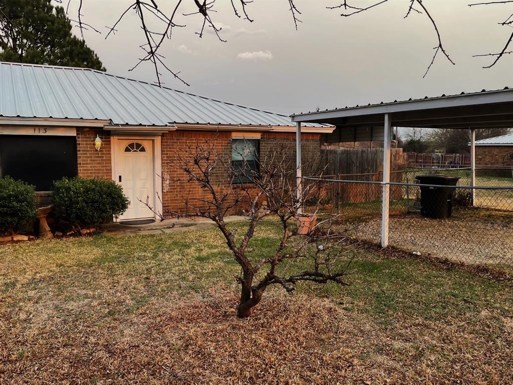
113 Cindy Ln
Weatherford, TX 76085
2 Weeks Ago
|
Edit
Favorites
-
Bedrooms
3
-
Bathrooms
2
-
Square Feet
1,216 sq ft
113 Cindy Ln

Favorites
Contact
- Listed by Locayt
Location
Get Directions
Weatherford is a city in the Dallas-Fort Worth metro area about 30 miles west of Fort Worth along Interstate 20. Weatherford is a quintessential Texas suburb made up of open lands and single-family houses sitting on spacious lots. Weatherford College sits towards the center of town, making the city a diverse and welcoming place. Route 171 and I-20 intersect near the southern border of town, making commutes easy as well as providing a spot for large plazas equipped with all the essentials. North of the intersection lies Main Street, which holds more dining and shopping options. Other parts of Weatherford are dotted with parks and green spaces like Love Street Park, Chandor Gardens, and the town’s namesake lake.
Learn more about living in Weatherford
Education
| Colleges & Universities | Distance | ||
|---|---|---|---|
| Colleges & Universities | Distance | ||
| Drive: | 33 min | 19.6 mi | |
| Drive: | 38 min | 23.2 mi | |
| Drive: | 39 min | 23.6 mi | |
| Drive: | 42 min | 25.1 mi |
113 Cindy Ln is within 42 minutes or 25.1 miles from Weatherford College. It is also near Tarrant Co. Coll., North West and UNT Health Fort Worth.
Getting Around
 What do Walkability, Transit, Drivability, and Bikeability mean?
Walkability measures the walking distance to day-to-day needs.
Transit measures access to public transportation.
Drivability measures congestion, parking availability, and access to major roads.
Bikeability measures the suitability for cycling.
How It Works
What do Walkability, Transit, Drivability, and Bikeability mean?
Walkability measures the walking distance to day-to-day needs.
Transit measures access to public transportation.
Drivability measures congestion, parking availability, and access to major roads.
Bikeability measures the suitability for cycling.
How It Works
Not Walkable
Walkability
10
/ 100
Exceptionally Drivable
Drivability
100
/ 100
Somewhat Bikeable
Bikeability
20
/ 100
Scores provided by
-
Soundscore™
-
/ 100
Traffic
-Airport
-Businesses
-Scores provided by
HowLoud What is a Sound Score Rating? A Sound Score Rating aggregates noise caused by vehicle traffic, airplane traffic and local sources. How It WorksYou May Also Like
Similar Rentals Nearby
-
-

-
 3 Beds, 2.5 Baths, 1,987 sq ft$3,6003721 Harley Ave Unit 2
 -
 3 Beds, 2.5 Baths, 1,549 sq ft$1,8753636 Dexter Ave Unit 3638
 -
 3 Beds, 2.5 Baths, 1,549 sq ft$1,8753636 Dexter Ave Unit 3632
 -
 3 Beds, 3 Baths, 2,463 sq ft$7,5002600 W 7th St Unit 2812
 -
 4 Beds, 4.5 Baths, 4,577 sq ft$20,000500 Throckmorton St Unit 3601
 -
 3 Beds, 3.5 Baths, 1,898 sq ft$2,3502821 Parmer Ave Unit 125
 -
 Condo for Rent3 Beds | 2 Baths | 1,099 sq ft
 -
 Condo for Rent4 Beds | 2 Baths | 1,385 sq ft
What Are Walk Score®, Transit Score®, and Bike Score® Ratings?
Walk Score® measures the walkability of any address. Transit Score® measures access to public transit. Bike Score® measures the bikeability of any address.
What is a Sound Score Rating?
A Sound Score Rating aggregates noise caused by vehicle traffic, airplane traffic and local sources.
113 Cindy Ln
Weatherford, TX 76085