

$5,950
/ Month
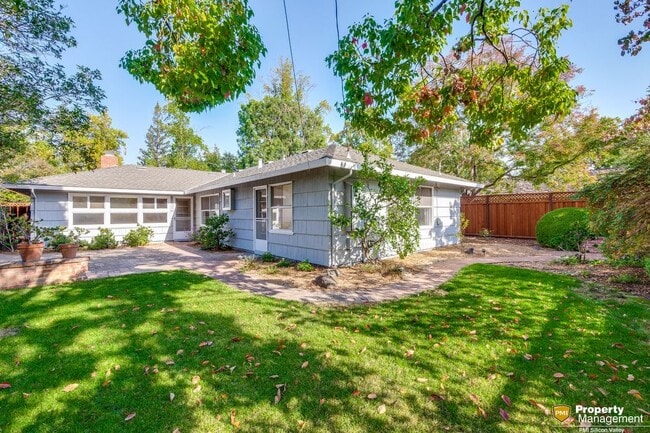
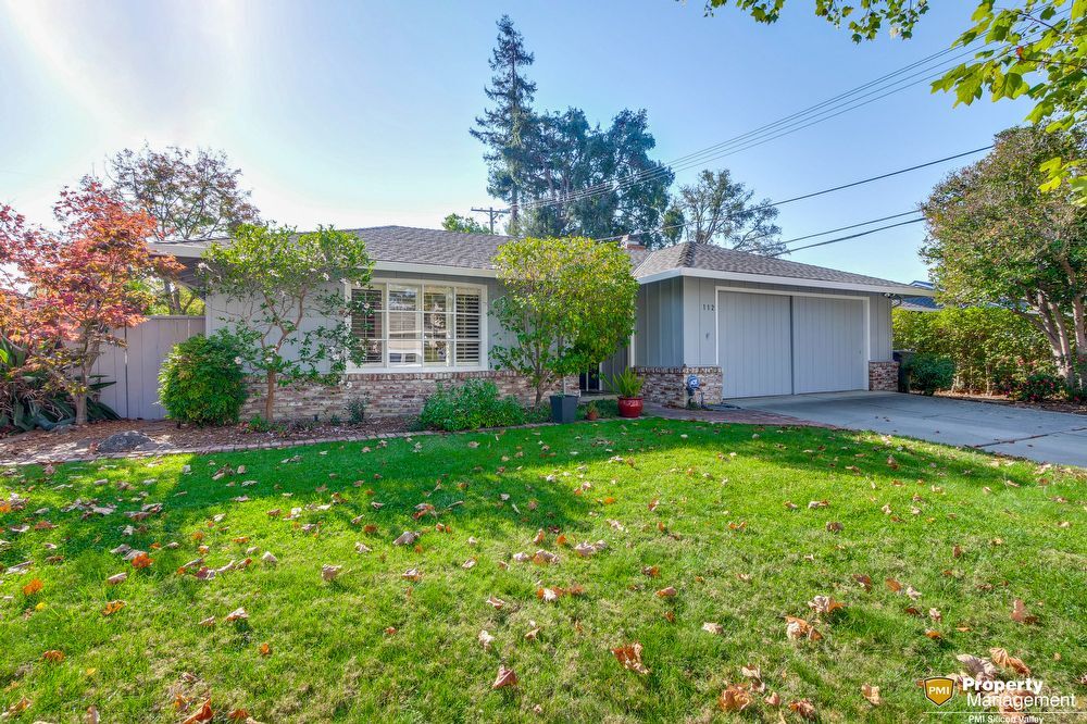
112 Lois Ln
Palo Alto, CA 94303
2 Weeks Ago
|
Edit
Favorites
112 Lois Ln

Favorites
Check Back Soon for Upcoming Availability
| Beds | Baths | Average SF |
|---|---|---|
| 4 Bedrooms 4 Bedrooms 4 Br | 2 Baths 2 Baths 2 Ba | 1,846 SF |
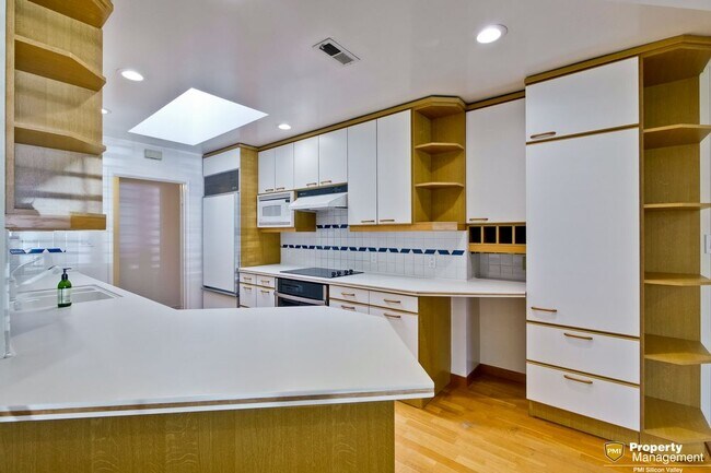
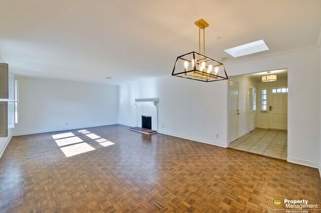
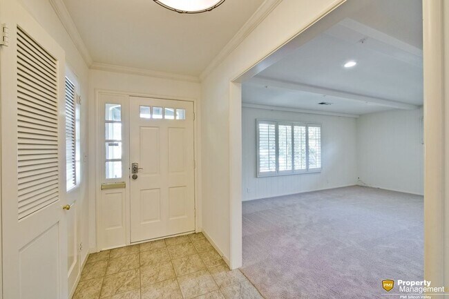
About This Property
Amazing home in a quiet tree-lined neighborhood. Open floor plan with updates throughout. Spacious yard with room to entertain and relax. Award Winning Palo Alto schools. Just minutes to Shopping restaurants and parks. Easy Commute to the entire Bay Area. This home will not last so call today for a tourAll Utilities Renters Liability Insurance Application/Screening Fee
112 Lois Ln is a house located in Santa Clara County and the 94303 ZIP Code. This area is served by the Palo Alto Unified School District attendance zone.
House Features
- Dishwasher
112 Lois Ln,
Palo Alto,
CA
94303
Living in Palo Alto places you in Silicon Valley, where historic neighborhoods complement the city's technological presence. Tree-lined streets wind through the community, which is anchored by Stanford University. University Avenue features local boutiques and restaurants housed in preserved historic buildings, while the Stanford Shopping Center offers high-end retail destinations. The city maintains 36 parks and preserves, including the Baylands Nature Preserve and Foothills Park, where residents enjoy hiking trails and outdoor activities. Palo Alto's infrastructure supports alternative transportation, with dedicated bike lanes throughout the city.
The rental market in Palo Alto reflects the area's popularity, with current average rents ranging from $2,634 for studios to $6,139 for four-bedroom homes. Recent trends show steady growth, with rent increases varying from 1.8% to 17% across different unit sizes over the past year.
Learn more about living in Palo AltoBelow are rent ranges for similar nearby apartments
Amenities
- Dishwasher
Education
| Colleges & Universities | Distance | ||
|---|---|---|---|
| Colleges & Universities | Distance | ||
| Drive: | 8 min | 2.8 mi | |
| Drive: | 9 min | 3.9 mi | |
| Drive: | 11 min | 4.1 mi | |
| Drive: | 17 min | 8.8 mi |
112 Lois Ln is within 8 minutes or 2.8 miles from Stanford University. It is also near Foothill College, Middlefield and Menlo College.
Schools


Public Elementary School
Grades K-5
407 Students
Nearby
Public Elementary School
Grades K-5
376 Students
Attendance Zone
Public Middle School
Grades 6-8
732 Students
Attendance Zone
Public High School
Grades 9-12
1,891 Students
Attendance Zone
Private Elementary & Middle School
Grades PK-8
26,250 Students
Nearby
Private Elementary & Middle School
Grades PK-8
192 Students
Nearby
Private Elementary School
Grades K-5
Nearby
Private Middle & High School
Grades 6-12
Nearby
School data provided by
 The GreatSchools Rating helps parents compare schools within a state based on a variety of school quality indicators and provides a helpful picture of how effectively each school serves all of its students. Ratings are on a scale of 1 (below average) to 10 (above average) and can include test scores, college readiness, academic progress, advanced courses, equity, discipline and attendance data. We also advise parents to visit schools, consider other information on school performance and programs, and consider family needs as part of the school selection process.
View GreatSchools Rating Methodology
Data provided by GreatSchools.org © 2026. All rights reserved.
View GreatSchools Rating Methodology
Data provided by GreatSchools.org © 2026. All rights reserved.
Transportation options available in Palo Alto include Bayshore Nasa Station, located 6.3 miles from 112 Lois Ln. 112 Lois Ln is near Norman Y Mineta San Jose International, located 13.8 miles or 20 minutes away, and San Francisco International, located 20.4 miles or 29 minutes away.
| Transit / Subway | Distance | ||
|---|---|---|---|
| Transit / Subway | Distance | ||
| Drive: | 10 min | 6.3 mi | |
| Drive: | 10 min | 6.7 mi | |
|
|
Drive: | 11 min | 6.8 mi |
|
|
Drive: | 11 min | 6.9 mi |
| Drive: | 11 min | 7.2 mi |
| Commuter Rail | Distance | ||
|---|---|---|---|
| Commuter Rail | Distance | ||
| Drive: | 6 min | 2.0 mi | |
| Drive: | 6 min | 2.4 mi | |
| Drive: | 8 min | 3.3 mi | |
| Drive: | 10 min | 4.7 mi | |
| Drive: | 12 min | 6.2 mi |
| Airports | Distance | ||
|---|---|---|---|
| Airports | Distance | ||
|
Norman Y Mineta San Jose International
|
Drive: | 20 min | 13.8 mi |
|
San Francisco International
|
Drive: | 29 min | 20.4 mi |
Walkability Near 112 Lois Ln Palo Alto, CA 94303
Getting Around
 What do Walkability, Transit, Drivability, and Bikeability mean?
Walkability measures the walking distance to day-to-day needs.
Transit measures access to public transportation.
Drivability measures congestion, parking availability, and access to major roads.
Bikeability measures the suitability for cycling.
How It Works
What do Walkability, Transit, Drivability, and Bikeability mean?
Walkability measures the walking distance to day-to-day needs.
Transit measures access to public transportation.
Drivability measures congestion, parking availability, and access to major roads.
Bikeability measures the suitability for cycling.
How It Works
Fairly Walkable
Walkability
50
/ 100
Limited Public Transit
Transit
30
/ 100
Exceptionally Drivable
Drivability
90
/ 100
Moderately Bikeable
Bikeability
70
/ 100
Scores provided by
-
Soundscore™
-
/ 100
Traffic
-Airport
-Businesses
-Scores provided by
HowLoud What is a Sound Score Rating? A Sound Score Rating aggregates noise caused by vehicle traffic, airplane traffic and local sources. How It WorksTime and distance from 112 Lois Ln.
| Shopping Centers | Distance | ||
|---|---|---|---|
| Shopping Centers | Distance | ||
| Walk: | 17 min | 0.9 mi | |
| Drive: | 4 min | 1.5 mi | |
| Drive: | 7 min | 2.1 mi |
112 Lois Ln has 3 shopping centers within 2.1 miles, which is about a 7-minute drive. The miles and minutes will be for the farthest away property.
| Parks and Recreation | Distance | ||
|---|---|---|---|
| Parks and Recreation | Distance | ||
|
Rinconada Park
|
Walk: | 8 min | 0.5 mi |
|
Junior Museum and Zoo
|
Walk: | 12 min | 0.6 mi |
|
Gamble Garden
|
Walk: | 17 min | 0.9 mi |
|
Hopkins Creekside Park
|
Drive: | 6 min | 1.9 mi |
|
The Environmental Volunteers EcoCenter
|
Drive: | 6 min | 2.0 mi |
112 Lois Ln has 5 parks within 2.0 miles, including Rinconada Park, Junior Museum and Zoo, and Gamble Garden.
| Hospitals | Distance | ||
|---|---|---|---|
| Hospitals | Distance | ||
| Drive: | 8 min | 2.6 mi | |
| Drive: | 9 min | 3.1 mi | |
| Drive: | 12 min | 6.8 mi |
112 Lois Ln has 3 hospitals within 6.8 miles, the nearest is Lucile Salter Packard Children's Hospital at Stanford which is 2.6 miles away and a 8 minute drive.
| Military Bases | Distance | ||
|---|---|---|---|
| Military Bases | Distance | ||
| Drive: | 13 min | 6.7 mi |
112 Lois Ln is 6.7 miles and a 13 minute drive from Ames Research Center.
You May Also Like
Similar Rentals Nearby


What Are Walk Score®, Transit Score®, and Bike Score® Ratings?
Walk Score® measures the walkability of any address. Transit Score® measures access to public transit. Bike Score® measures the bikeability of any address.
What is a Sound Score Rating?
A Sound Score Rating aggregates noise caused by vehicle traffic, airplane traffic and local sources.
112 Lois Ln
Palo Alto, CA 94303