


$2,300 / Month
112 Antonette Ave
San Rafael, CA 94901
2 Weeks Ago
Favorites
112 Antonette Ave

Favorites
Check Back Soon for Upcoming Availability
| Beds | Baths | Average SF |
|---|---|---|
| 1 Bedroom 1 Bedroom 1 Br | 1 Bath 1 Bath 1 Ba | 450 SF |
Fees and Policies
The fees below are based on community-supplied data and may exclude additional fees and utilities.
- Dogs Allowed
-
Fees not specified
-
Weight limit--
-
Pet Limit--
Details
Utilities Included
-
Trash Removal
About This Property
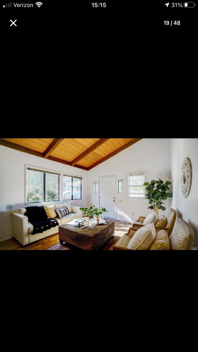
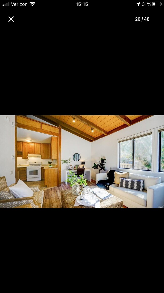
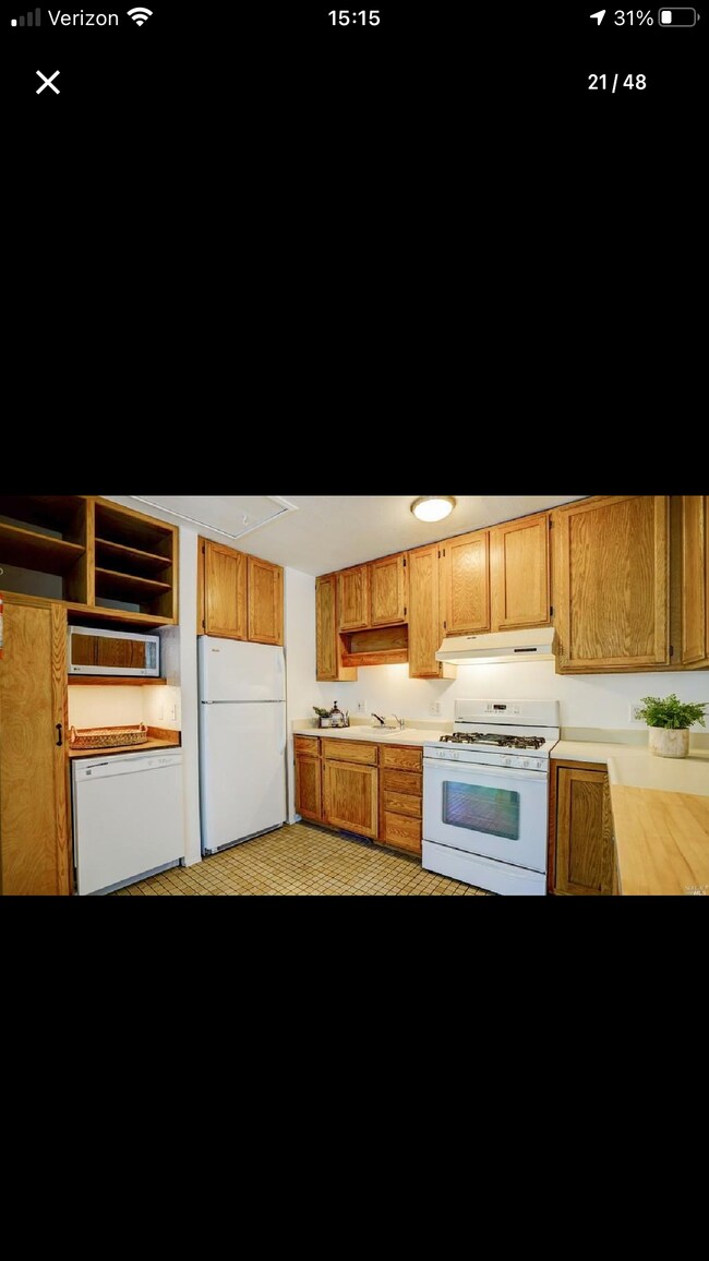
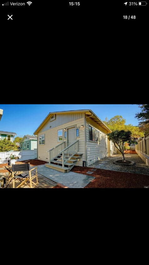
Charming 1937 vintage Gerstle Park 1 bedroom 1 bath single story home in a front back duplex. Each unit has separate entrances. Tree lined corner located on upper C Street. Available August 1, 2024 Sunny spacious front and side yard. Immaculate, move-in condition with newly painted exterior. Vaulted ceilings with a loft accessible from a ladder. Full kitchen with gas stove and dishwasher. Oak hardwood floors in the bedroom, with a tile kitchen and laminate floors in the living room. Large bright bedroom with closet. Central heat. Shared laundry. One off street parking spot in driveway and ample street parking. Unit comes with a small one car garage for storage. Walking distance to historic Gerstle Park, Marin Bocce, community center and vibrant downtown San Rafael. San Rafael has a great Thursday night farmers market, theater, and lots of restaurants. Excellent SF and East Bay commute location. Close to smart train and Golden Gate Transit. Rent is $2300/ Month Security Deposit is $2300 (first half is due with first months rent - second half with second months rent) Garbage is included Tenant pays all other utilities (water split with second unit) Pets are negotiable NO SMOKING
112 Antonette Ave is a house located in Marin County and the 94901 ZIP Code.
House Features
Dishwasher
Hardwood Floors
Smoke Free
Heating
- Heating
- Smoke Free
- Cable Ready
- Storage Space
- Dishwasher
- Kitchen
- Hardwood Floors
- Laundry Facilities
- Yard
Location
Get Directions
Lush greenery lines the Gerstle Park neighborhood’s extensive sidewalk system, giving residents every excuse to walk up the 4th Street or B Street for groceries, morning coffee, or after-hours R&R. On the south side of the neighborhood, the eponymous park’s playgrounds, footpaths, and shady trees provide a delightful spot to relax and enjoy the outdoors.
Multiple elementary schools in the Gerstle Park area give parents options for their children’s education, and of course walking to class is one of the many perks of the neighborhood’s cozy layout (James B. Davidson Middle School sits just outside the neighborhood as well). Convenient access to the 101 and Interstate 580 makes it easy to reach Oakland or San Francisco in under an hour.
Learn more about living in Gerstle ParkBelow are rent ranges for similar nearby apartments
Amenities
- Heating
- Smoke Free
- Cable Ready
- Storage Space
- Dishwasher
- Kitchen
- Hardwood Floors
- Laundry Facilities
- Yard
Expenses
Utilities Included
Trash Removal
Included
Education
| Colleges & Universities | Distance | ||
|---|---|---|---|
| Colleges & Universities | Distance | ||
| Drive: | 7 min | 2.3 mi | |
| Drive: | 26 min | 15.0 mi | |
| Drive: | 27 min | 15.9 mi | |
| Drive: | 29 min | 16.2 mi |
112 Antonette Ave is within 7 minutes or 2.3 miles from Dominican Univ. of Ca. It is also near Contra Costa College and UC San Francisco, Mount Zion.
Transportation options available in San Rafael include Richmond Station, located 12.2 miles from 112 Antonette Ave. 112 Antonette Ave is near San Francisco International, located 30.8 miles or 51 minutes away, and Metro Oakland International, located 32.0 miles or 45 minutes away.
| Transit / Subway | Distance | ||
|---|---|---|---|
| Transit / Subway | Distance | ||
|
|
Drive: | 21 min | 12.2 mi |
| Commuter Rail | Distance | ||
|---|---|---|---|
| Commuter Rail | Distance | ||
| Drive: | 4 min | 1.4 mi | |
| Drive: | 8 min | 2.9 mi | |
| Drive: | 9 min | 4.8 mi | |
| Drive: | 15 min | 8.2 mi | |
| Drive: | 20 min | 12.1 mi |
| Airports | Distance | ||
|---|---|---|---|
| Airports | Distance | ||
|
San Francisco International
|
Drive: | 51 min | 30.8 mi |
|
Metro Oakland International
|
Drive: | 45 min | 32.0 mi |
Time and distance from 112 Antonette Ave.
| Shopping Centers | Distance | ||
|---|---|---|---|
| Shopping Centers | Distance | ||
| Walk: | 18 min | 0.9 mi | |
| Drive: | 3 min | 1.1 mi | |
| Drive: | 4 min | 1.3 mi |
112 Antonette Ave has 3 shopping centers within 1.3 miles, which is about a 4-minute walk. The miles and minutes will be for the farthest away property.
| Parks and Recreation | Distance | ||
|---|---|---|---|
| Parks and Recreation | Distance | ||
|
WildCare
|
Walk: | 11 min | 0.6 mi |
|
Hal Brown Park at Creekside
|
Drive: | 5 min | 1.7 mi |
|
Baltimore Canyon Open Space
|
Drive: | 14 min | 4.3 mi |
|
Ring Mountain Preserve
|
Drive: | 15 min | 6.5 mi |
|
China Camp State Park
|
Drive: | 16 min | 6.7 mi |
112 Antonette Ave has 5 parks within 6.7 miles, including WildCare, Hal Brown Park at Creekside, and Baltimore Canyon Open Space.
| Hospitals | Distance | ||
|---|---|---|---|
| Hospitals | Distance | ||
| Drive: | 6 min | 2.0 mi | |
| Drive: | 11 min | 5.1 mi | |
| Drive: | 18 min | 11.1 mi |
112 Antonette Ave has 3 hospitals within 11.1 miles, the nearest is MarinHealth Medical Center which is 2.0 miles away and a 6 minute drive.
| Military Bases | Distance | ||
|---|---|---|---|
| Military Bases | Distance | ||
| Drive: | 26 min | 15.2 mi | |
| Drive: | 29 min | 15.7 mi | |
| Drive: | 30 min | 16.1 mi |
112 Antonette Ave has 3 military bases within 16.1 miles, the nearest is Armory West Contra Costa which is 15.2 miles away and a 26 minute drive.
You May Also Like
Similar Rentals Nearby


What Are Walk Score®, Transit Score®, and Bike Score® Ratings?
Walk Score® measures the walkability of any address. Transit Score® measures access to public transit. Bike Score® measures the bikeability of any address.
What is a Sound Score Rating?
A Sound Score Rating aggregates noise caused by vehicle traffic, airplane traffic and local sources
112 Antonette Ave
San Rafael, CA 94901