
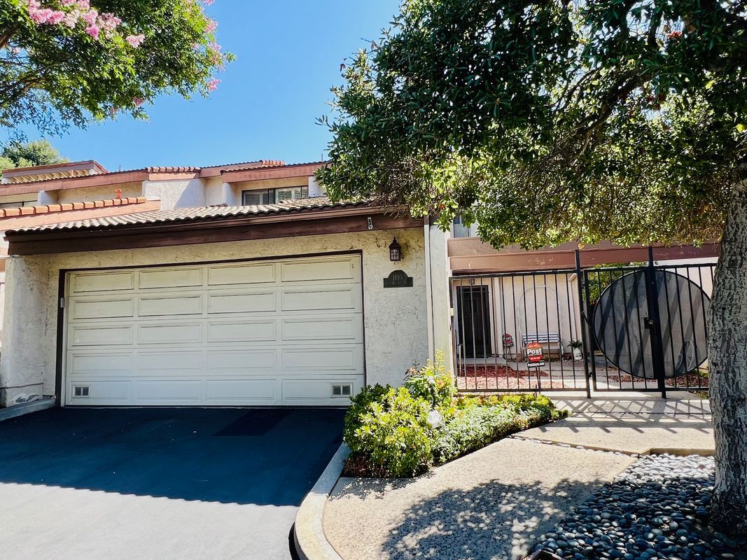
1110 Las Riendas Way
Pasadena, CA 91107
-
Bedrooms
3
-
Bathrooms
3
-
Square Feet
2,243 sq ft
-
Available
Available Now
Highlights
- Pool
- Controlled Access

About This Home
Discover this charming townhouse located in the heart of Pasadena, CA. With three spacious bedrooms and three bathrooms, this 2,243 square-foot residence is perfect for those seeking both comfort and convenience. Key property features include a dedicated parking spot, an attached garage, and a two-story layout with a tiled roof. Enjoy community amenities such as a refreshing pool and shared outdoor space for relaxation and social gatherings. The home is designed for modern living, featuring essential appliances like a washer and dryer, and boasts central heating and cooling for year-round comfort. Utilities include water and trash service, with the homeowners association managing property maintenance. Proximity to top-rated San Marino Schools, retail and transit all within easy access. This townhouse combines a vibrant lifestyle with essential accessibility. Don’t miss this opportunity—schedule your tour today!
1110 Las Riendas Way is a townhome located in Los Angeles County and the 91107 ZIP Code. This area is served by the San Marino Unified attendance zone.
Townhome Features
Washer/Dryer
Air Conditioning
Dishwasher
Microwave
- Washer/Dryer
- Air Conditioning
- Dishwasher
- Disposal
- Microwave
- Refrigerator
- Controlled Access
- Renters Insurance Program
- Pool
Fees and Policies
The fees below are based on community-supplied data and may exclude additional fees and utilities.
- Parking
-
Other--Assigned Parking
Details
Utilities Included
-
Water
-
Trash Removal
Lease Options
-
12 Months
Contact
- Phone Number
- Website View Property Website
- Contact
-
Source

- Washer/Dryer
- Air Conditioning
- Dishwasher
- Disposal
- Microwave
- Refrigerator
- Controlled Access
- Renters Insurance Program
- Pool
Mid-century ranch homes and large apartment complexes fill the streets of Far East Pasadena, with some arts and crafts gems dotted here and there toward the western end of the neighborhood. Residents often pick up dinner from local diners with a long history in the community.
To enjoy the outdoors, locals head into the San Gabriel Mountains to the north of the neighborhood for hiking. To the west of the area, Pasadena City College stands as one of the premier junior colleges in Southern California. Most local residents commute to work in nearby Pasadena, San Gabriel Valley, or downtown Los Angeles.
Learn more about living in East Pasadena| Colleges & Universities | Distance | ||
|---|---|---|---|
| Colleges & Universities | Distance | ||
| Drive: | 7 min | 2.8 mi | |
| Drive: | 7 min | 3.6 mi | |
| Drive: | 9 min | 4.6 mi | |
| Drive: | 10 min | 4.9 mi |


View GreatSchools Rating Methodology
Data provided by GreatSchools.org © 2025. All rights reserved.
Transportation options available in Pasadena include Sierra Madre Villa Station, located 3.6 miles from 1110 Las Riendas Way. 1110 Las Riendas Way is near Bob Hope, located 21.7 miles or 30 minutes away, and Long Beach (Daugherty Field), located 27.0 miles or 41 minutes away.
| Transit / Subway | Distance | ||
|---|---|---|---|
| Transit / Subway | Distance | ||
|
|
Drive: | 6 min | 3.6 mi |
| Drive: | 8 min | 4.0 mi | |
|
|
Drive: | 8 min | 4.1 mi |
|
|
Drive: | 11 min | 4.4 mi |
|
|
Drive: | 10 min | 6.1 mi |
| Commuter Rail | Distance | ||
|---|---|---|---|
| Commuter Rail | Distance | ||
|
|
Drive: | 13 min | 6.5 mi |
|
|
Drive: | 22 min | 10.4 mi |
|
|
Drive: | 20 min | 10.5 mi |
|
|
Drive: | 21 min | 12.4 mi |
| Drive: | 23 min | 16.2 mi |
| Airports | Distance | ||
|---|---|---|---|
| Airports | Distance | ||
|
Bob Hope
|
Drive: | 30 min | 21.7 mi |
|
Long Beach (Daugherty Field)
|
Drive: | 41 min | 27.0 mi |
Time and distance from 1110 Las Riendas Way.
| Shopping Centers | Distance | ||
|---|---|---|---|
| Shopping Centers | Distance | ||
| Walk: | 7 min | 0.4 mi | |
| Drive: | 2 min | 1.2 mi | |
| Drive: | 3 min | 1.6 mi |
| Parks and Recreation | Distance | ||
|---|---|---|---|
| Parks and Recreation | Distance | ||
|
Huntington Botanical Gardens
|
Drive: | 7 min | 2.4 mi |
|
Los Angeles County Arboretum
|
Drive: | 6 min | 3.1 mi |
|
Eaton Canyon Nature Center
|
Drive: | 9 min | 4.3 mi |
|
Chilao Visitor Center
|
Drive: | 7 min | 4.7 mi |
|
Grassy Hollow Visitor Center
|
Drive: | 7 min | 4.7 mi |
| Hospitals | Distance | ||
|---|---|---|---|
| Hospitals | Distance | ||
| Drive: | 3 min | 1.7 mi | |
| Drive: | 6 min | 2.6 mi | |
| Drive: | 6 min | 3.4 mi |
| Military Bases | Distance | ||
|---|---|---|---|
| Military Bases | Distance | ||
| Drive: | 41 min | 29.0 mi | |
| Drive: | 45 min | 30.6 mi |
You May Also Like
What Are Walk Score®, Transit Score®, and Bike Score® Ratings?
Walk Score® measures the walkability of any address. Transit Score® measures access to public transit. Bike Score® measures the bikeability of any address.
What is a Sound Score Rating?
A Sound Score Rating aggregates noise caused by vehicle traffic, airplane traffic and local sources
1110 Las Riendas Way
Pasadena, CA 91107