


$999
/ Month
110 S High St
Sugar Creek, MO 64054
Today
|
Edit
Favorites
816-944-3154
-
Bedrooms
2
-
Bathrooms
1
-
Square Feet
700 sq ft
-
Available
Available Now
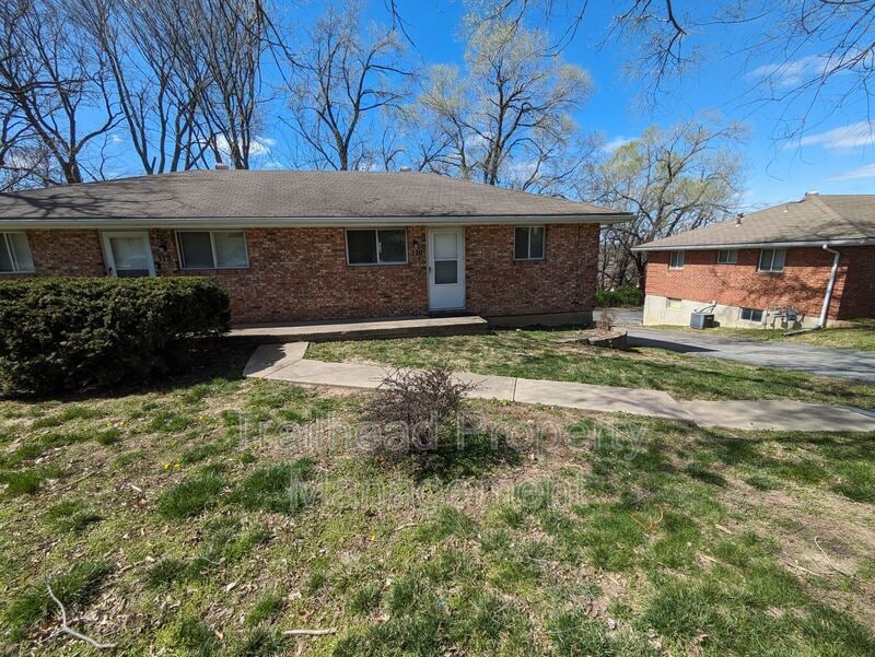
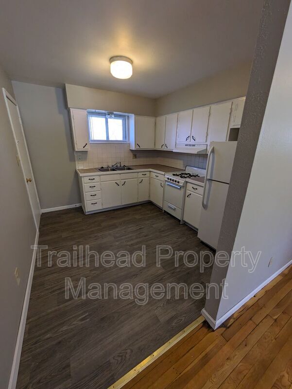
110 S High St

Favorites
About This Home
$999 deposit,
Available Now
This fantastic 2 bedroom 1 bath home in Sugar Creek is available for immediate move in. Close to everything the location cannot be beat. Natural light adds a beautiful warmth to your new home and hardwood floors with neutral walls open up to a decorating palette to make all your own. Entertaining is a breeze in this large eat in kitchen with plenty of counterspace and cabinets. The spacious bedrooms and bathroom with tub make this the perfect home for roommates and families. Washer dryer hookups in the basement as well as a one car garage (with additional parking available). Check website for video tour! Don't hesitate - this will go fast! HOUSING VOUCHER ACCEPTED! Application Fee: $60 per person over the age of 18 Administration Fee: $100 Non-Refundable Pet Fee: $300 Monthly Pet Rent: $25
110 S High St is a house located in Jackson County and the 64054 ZIP Code. This area is served by the Independence 30 attendance zone.
* Price shown is base rent. Excludes user-selected optional fees and variable or usage-based fees and required charges due at or prior to move-in or at move-out. Price, availability, fees, and any applicable rent special are subject to change without notice.
* Square footage definitions vary. Displayed square footage is approximate.
Fees and Policies
The fees below are based on community-supplied data and may exclude additional fees and utilities.
- One-Time Basics
- Due at Move-In
- Security Deposit - RefundableCharged per unit.$999
- Due at Move-In
- Dogs
- Allowed
- Cats
- Allowed
Property Fee Disclaimer: Based on community-supplied data and independent market research. Subject to change without notice. May exclude fees for mandatory or optional services and usage-based utilities.
Contact
- Phone Number
- Contact
Location
Get Directions
Nestled along the Missouri River, Sugar Creek is a small town bordering Kansas City. Filled with industrial and manufacturing warehouses, multiple parks, and open pastures of land, Sugar Creek feels rural. With excellent parks and access to the river, many residents spend their time outdoors at LaBanite Park or William Henry Harrison Park. Sugar Creek’s biggest allure is its proximity to Kansas City. Many residents travel into the city for work or play. By living in Sugar Creek, you’ll be within minutes from some of Kansas City’s best restaurants, shopping centers, museums, attractions, and more. U.S. Highway 24 and Interstate 435 make traveling throughout metro Kansas City easy. To sweeten the deal even more, Sugar Creek has a variety of affordable houses, townhomes, and apartments available for rent.
Learn more about living in Sugar Creek
Education
| Colleges & Universities | Distance | ||
|---|---|---|---|
| Colleges & Universities | Distance | ||
| Drive: | 4 min | 1.8 mi | |
| Drive: | 22 min | 12.7 mi | |
| Drive: | 23 min | 12.8 mi | |
| Drive: | 23 min | 13.5 mi |
110 S High St is within 4 minutes or 1.8 miles from Graceland University. It is also near Kansas City Art Institute and Rockhurst University.
Schools


Public Elementary School
Grades 2-5
272 Students
Attendance Zone
Public Elementary School
Grades PK-1
140 Students
Attendance Zone
Public Middle School
Grades 6-8
875 Students
Attendance Zone
Public High School
Grades 9-12
1,047 Students
Attendance Zone
Private Elementary, Middle & High School
Grades PK-12
204 Students
Nearby
Private Elementary & Middle School
Grades PK-8
Nearby
School data provided by
 The GreatSchools Rating helps parents compare schools within a state based on a variety of school quality indicators and provides a helpful picture of how effectively each school serves all of its students. Ratings are on a scale of 1 (below average) to 10 (above average) and can include test scores, college readiness, academic progress, advanced courses, equity, discipline and attendance data. We also advise parents to visit schools, consider other information on school performance and programs, and consider family needs as part of the school selection process.
View GreatSchools Rating Methodology
Data provided by GreatSchools.org © 2025. All rights reserved.
View GreatSchools Rating Methodology
Data provided by GreatSchools.org © 2025. All rights reserved.
Transportation options available in Sugar Creek include Library On Main At 9Th St Sb, located 8.3 miles from 110 S High St. 110 S High St is near Kansas City International, located 28.6 miles or 39 minutes away.
| Transit / Subway | Distance | ||
|---|---|---|---|
| Transit / Subway | Distance | ||
| Drive: | 17 min | 8.3 mi | |
| Drive: | 18 min | 8.4 mi | |
| Drive: | 17 min | 8.4 mi | |
| Drive: | 18 min | 8.6 mi | |
| Drive: | 18 min | 8.7 mi |
| Commuter Rail | Distance | ||
|---|---|---|---|
| Commuter Rail | Distance | ||
|
|
Drive: | 6 min | 2.6 mi |
|
|
Drive: | 20 min | 9.7 mi |
|
|
Drive: | 28 min | 18.5 mi |
| Airports | Distance | ||
|---|---|---|---|
| Airports | Distance | ||
|
Kansas City International
|
Drive: | 39 min | 28.6 mi |
Time and distance from 110 S High St.
| Shopping Centers | Distance | ||
|---|---|---|---|
| Shopping Centers | Distance | ||
| Walk: | 3 min | 0.2 mi | |
| Walk: | 9 min | 0.5 mi | |
| Walk: | 11 min | 0.6 mi |
110 S High St has 3 shopping centers within 0.6 mile, which is about a 11-minute walk. The miles and minutes will be for the farthest away property.
| Parks and Recreation | Distance | ||
|---|---|---|---|
| Parks and Recreation | Distance | ||
|
Harry S Truman National Historic Site
|
Drive: | 5 min | 2.7 mi |
|
George Owens Nature Park
|
Drive: | 15 min | 7.1 mi |
|
Richard Berkley Riverfront Park
|
Drive: | 17 min | 8.0 mi |
|
Science City at Union Station
|
Drive: | 20 min | 9.5 mi |
|
William M. Klein Park (aka: Cave Spring)
|
Drive: | 17 min | 10.9 mi |
110 S High St has 5 parks within 10.9 miles, including Harry S Truman National Historic Site, George Owens Nature Park, and Richard Berkley Riverfront Park.
| Hospitals | Distance | ||
|---|---|---|---|
| Hospitals | Distance | ||
| Drive: | 18 min | 8.7 mi | |
| Drive: | 17 min | 8.8 mi | |
| Drive: | 18 min | 9.3 mi |
110 S High St has 3 hospitals within 9.3 miles, the nearest is Center for Behavioral Medicine which is 8.7 miles away and a 18 minute drive.
| Military Bases | Distance | ||
|---|---|---|---|
| Military Bases | Distance | ||
| Drive: | 62 min | 42.4 mi |
110 S High St is 42.4 miles and a 62 minute drive from Fort Leavenworth.
You May Also Like
Similar Rentals Nearby


What Are Walk Score®, Transit Score®, and Bike Score® Ratings?
Walk Score® measures the walkability of any address. Transit Score® measures access to public transit. Bike Score® measures the bikeability of any address.
What is a Sound Score Rating?
A Sound Score Rating aggregates noise caused by vehicle traffic, airplane traffic and local sources

110 S High St
Sugar Creek, MO 64054