
$1,500
Total Monthly Price
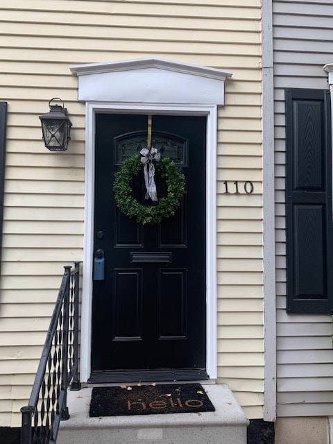
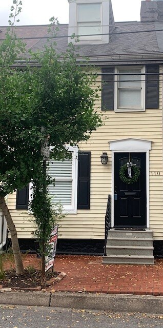
110 Nagle St
Harrisburg, PA 17104
Favorites
717-255-0515
-
Bedrooms
2
-
Bathrooms
1
-
Square Feet
1,300 sq ft
-
Available
Available Now
Highlights
- Pets Allowed
- Yard
- Smoke Free
110 Nagle St

Favorites
About This Home
12 Month Lease,
$1,500 deposit,
Available Now
Historic Shipoke! Private historic rowhome. Sunny two bedroom with 3rd-floor bonus space (office, tv room, storage) with one large bathroom. Home is unfurnished pictures for reference. Newly updated. Washer and Dryer, gas heat, permit parking. Private fenced back yard. Steps away from river walk/bike path, Harrisburg Greenbelt. Walk to Harrisburg's finest restaurants, nightlife and hospital. Located in an upscale community. Easy access to highways and downtown. Due to the popularity of this location we will accept successful applicants in the order of application process number. Tenant pays utilities Credit Check and references
110 Nagle St is a townhome located in Dauphin County and the 17104 ZIP Code. This area is served by the Harrisburg City School District attendance zone.
* Price shown is total price based on community-supplied monthly required fees. Excludes user-selected optional fees and variable or usage-based fees and required charges due at or prior to move-in or at move-out. Price, availability, fees, and any applicable rent special are subject to change without notice.
* Square footage definitions vary. Displayed square footage is approximate.
Townhome Features
Washer/Dryer
Tub/Shower
Office
Smoke Free
- Washer/Dryer
- Smoke Free
- Cable Ready
- Storage Space
- Tub/Shower
- Office
- Walking/Biking Trails
- Yard
Fees and Policies
The fees listed below are community-provided and may exclude utilities or add-ons. All payments are made directly to the property and are non-refundable unless otherwise specified.
- Parking
-
Street--
Details
Lease Options
-
12
Contact
- Phone Number
- Contact
Location
Get Directions
Downtown Harrisburg sits adjacent to the winding Susquehanna River, blending big-city amenities with a surprising amount of green space. Residents see this district as a refreshing urban neighborhood in which historic buildings like the John Harris-Simon Cameron Mansion sit comfortably next to modern architectural projects. Getting to Interstate 83 is a breeze for locals, which borders the neighborhood’s south side, making it easy to commute to work or school.
Downtown offers unique entertainment options at locales like the Whitaker Center for Science and the Arts. Residents and visitors alike rave about the lively pubs and eateries serving sushi, tacos, Indian cuisine, and so much more along 2nd Street. Downtown Harrisburg is extremely walkable and bike-friendly, so you’ll enjoy strolling or biking along the river taking in the scenic views and historic charm that this neighborhood offers.
Learn more about living in Downtown Harrisburg
Education
| Colleges & Universities | Distance | ||
|---|---|---|---|
| Colleges & Universities | Distance | ||
| Drive: | 11 min | 4.3 mi | |
| Drive: | 20 min | 10.8 mi | |
| Drive: | 22 min | 12.2 mi | |
| Drive: | 32 min | 20.4 mi |
110 Nagle St is within 11 minutes or 4.3 miles from Harrisburg C.C., Harrisburg. It is also near Penn State Harrisburg and Messiah College.
Schools


Public Elementary School
Grades PK-5
160 Students
Nearby
Public Elementary School
Grades K-5
216 Students
Nearby
Public Middle School
Grades 6-8
588 Students
Nearby
Public High School
Grades 9-12
323 Students
Nearby
Private Elementary & Middle School
Grades PK-8
139 Students
Nearby
Private Elementary, Middle & High School
Grades K-12
Nearby
School data provided by
 The GreatSchools Rating helps parents compare schools within a state based on a variety of school quality indicators and provides a helpful picture of how effectively each school serves all of its students. Ratings are on a scale of 1 (below average) to 10 (above average) and can include test scores, college readiness, academic progress, advanced courses, equity, discipline and attendance data. We also advise parents to visit schools, consider other information on school performance and programs, and consider family needs as part of the school selection process.
View GreatSchools Rating Methodology
Data provided by GreatSchools.org © 2026. All rights reserved.
View GreatSchools Rating Methodology
Data provided by GreatSchools.org © 2026. All rights reserved.
Getting Around
 What do Walkability, Transit, Drivability, and Bikeability mean?
Walkability measures the walking distance to day-to-day needs.
Transit measures access to public transportation.
Drivability measures congestion, parking availability, and access to major roads.
Bikeability measures the suitability for cycling.
How It Works
What do Walkability, Transit, Drivability, and Bikeability mean?
Walkability measures the walking distance to day-to-day needs.
Transit measures access to public transportation.
Drivability measures congestion, parking availability, and access to major roads.
Bikeability measures the suitability for cycling.
How It Works
Fairly Walkable
Walkability
50
/ 100
Limited Public Transit
Transit
20
/ 100
Exceptionally Drivable
Drivability
90
/ 100
Moderately Bikeable
Bikeability
70
/ 100
Scores provided by
-
Soundscore™
-
/ 100
Traffic
-Airport
-Businesses
-Scores provided by
HowLoud What is a Sound Score Rating? A Sound Score Rating aggregates noise caused by vehicle traffic, airplane traffic and local sources. How It Works
Amenities
- Washer/Dryer
- Smoke Free
- Cable Ready
- Storage Space
- Tub/Shower
- Office
- Yard
- Walking/Biking Trails
110 Nagle St Photos
-
-
-
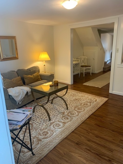
living room
-
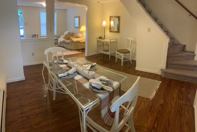
dining room
-
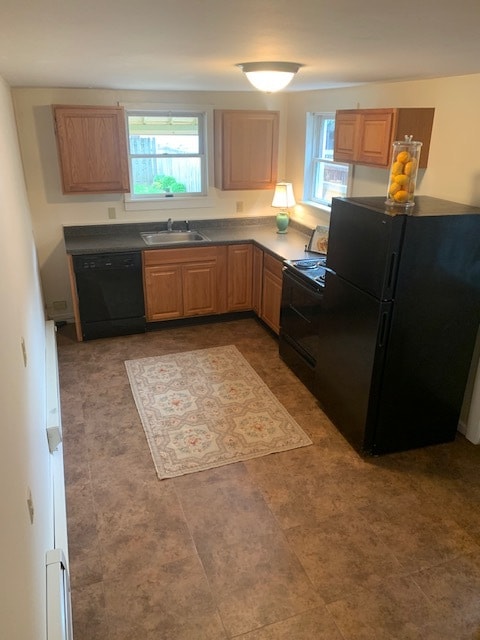
kitchen
-
-
-
extra large bathroom with storage
-
Primary Bedroom
What Are Walk Score®, Transit Score®, and Bike Score® Ratings?
Walk Score® measures the walkability of any address. Transit Score® measures access to public transit. Bike Score® measures the bikeability of any address.
What is a Sound Score Rating?
A Sound Score Rating aggregates noise caused by vehicle traffic, airplane traffic and local sources.
110 Nagle St
Harrisburg, PA 17104