

$1,795
/ Month
1063 Granjas Rd Unit 232
Chula Vista, CA 91911
Today
|
Edit
Favorites
619-476-9920
-
Bedrooms
1
-
Bathrooms
1
-
Square Feet
550 sq ft
-
Available
Available Now
1063 Granjas Rd Unit 232

Favorites
About This Home
$1,500 deposit,
Available Now
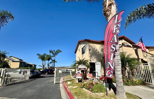
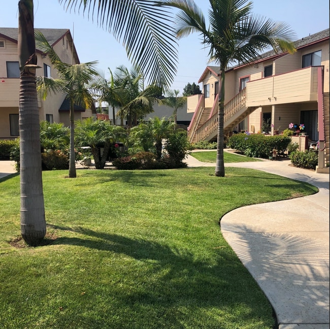
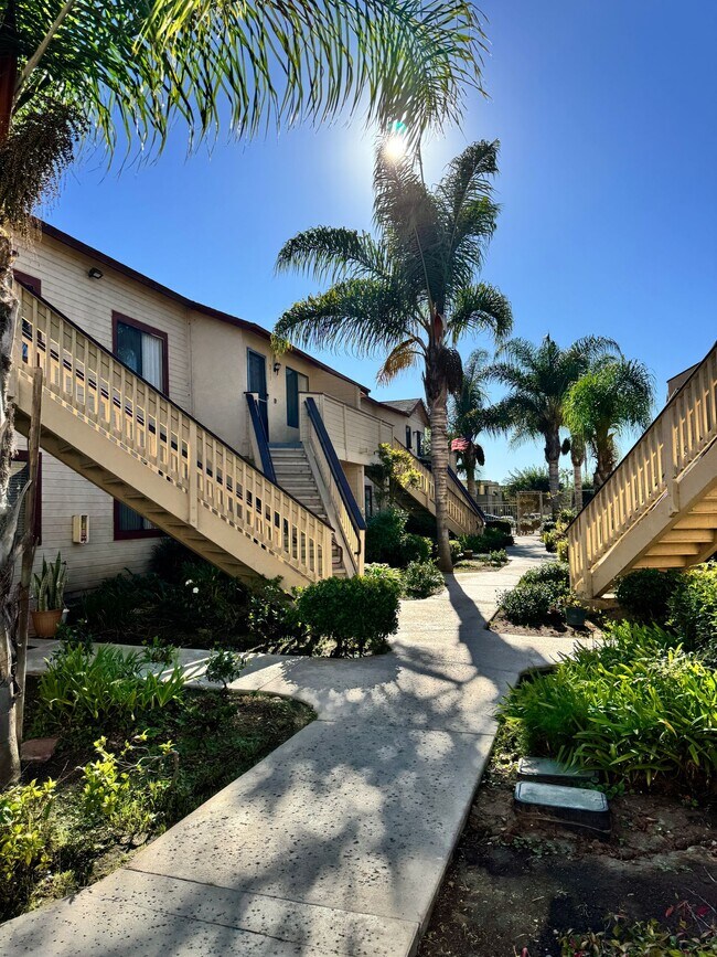
Peaceful and private living awaits in this cozy 1-bedroom, 1-bath home located in a quiet cul-de-sac within a welcoming 55+ senior community. The unit offers plenty of cabinet space, a comfortable layout, and access to a community recreation room—perfect for social activities and gatherings. Enjoy a calm atmosphere with friendly neighbors, close to shopping, dining, and essential services. Features: • 1 spacious bedroom, 1 bathroom • Ample cabinet and storage space • Access to recreation/community room • Community grill • Quiet cul-de-sac location • Peaceful 55+ senior living community **We Accept Section 8** Contact us today at for more details or to schedule a viewing! Move-in Special- $200 off First month's rent!
1063 Granjas Rd is an apartment community located in San Diego County and the 91911 ZIP Code.
* Price shown is base rent. Excludes user-selected optional fees and variable or usage-based fees and required charges due at or prior to move-in or at move-out. Price, availability, fees, and any applicable rent special are subject to change without notice.
* Square footage definitions vary. Displayed square footage is approximate.
Fees and Policies
The fees listed below are community-provided and may exclude utilities or add-ons. All payments are made directly to the property and are non-refundable unless otherwise specified. Use the Cost Calculator to determine costs based on your needs.
-
One-Time Basics
-
Due at Move-In
-
Security Deposit - RefundableCharged per unit.$1,500
-
-
Due at Move-In
Property Fee Disclaimer: Based on community-supplied data and independent market research. Subject to change without notice. May exclude fees for mandatory or optional services and usage-based utilities.
Contact
- Listed by The Meadows CV, L.P. | The Meadows CV, L.P.
- Phone Number
- Contact
Location
Get Directions
The Harborside neighborhood, just a 15-minute drive from downtown San Diego, is located at the western end of Chula Vista near the San Diego bay. Residents can avoid traffic and easily reach downtown by taking the San Diego Trolley's blue line. The neighborhood has a large number of apartments and wraps around a park of the same name.
Harborside is located between L Street to the north, Palomar Street and Orange Avenue to the south, the bay to the west, and Third Avenue to the east. I-5 runs along the west side of the neighborhood, providing fast commutes to nearby San Diego.
Learn more about living in Harborside
Education
| Colleges & Universities | Distance | ||
|---|---|---|---|
| Colleges & Universities | Distance | ||
| Drive: | 13 min | 6.5 mi | |
| Drive: | 12 min | 9.8 mi | |
| Drive: | 13 min | 10.2 mi | |
| Drive: | 13 min | 10.9 mi |
1063 Granjas Rd Unit 232 is within 13 minutes or 6.5 miles from Southwestern Coll, Chula Vista. It is also near San Diego City College and Thomas Jefferson School of Law.
Transportation options available in Chula Vista include Palomar Street, located 0.9 mile from 1063 Granjas Rd Unit 232. 1063 Granjas Rd Unit 232 is near San Diego International, located 13.1 miles or 17 minutes away.
| Transit / Subway | Distance | ||
|---|---|---|---|
| Transit / Subway | Distance | ||
|
|
Walk: | 17 min | 0.9 mi |
|
|
Drive: | 5 min | 2.1 mi |
|
|
Drive: | 4 min | 2.8 mi |
|
|
Drive: | 6 min | 2.9 mi |
|
|
Drive: | 7 min | 3.5 mi |
| Commuter Rail | Distance | ||
|---|---|---|---|
| Commuter Rail | Distance | ||
|
|
Drive: | 15 min | 11.1 mi |
|
|
Drive: | 17 min | 14.0 mi |
|
|
Drive: | 31 min | 25.7 mi |
|
|
Drive: | 40 min | 32.8 mi |
|
|
Drive: | 44 min | 36.5 mi |
| Airports | Distance | ||
|---|---|---|---|
| Airports | Distance | ||
|
San Diego International
|
Drive: | 17 min | 13.1 mi |
Time and distance from 1063 Granjas Rd Unit 232.
| Shopping Centers | Distance | ||
|---|---|---|---|
| Shopping Centers | Distance | ||
| Walk: | 2 min | 0.1 mi | |
| Walk: | 4 min | 0.3 mi | |
| Walk: | 6 min | 0.3 mi |
1063 Granjas Rd Unit 232 has 3 shopping centers within 0.3 mile, which is about a 6-minute walk. The miles and minutes will be for the farthest away property.
| Parks and Recreation | Distance | ||
|---|---|---|---|
| Parks and Recreation | Distance | ||
|
Otay Valley Regional Park
|
Drive: | 4 min | 1.8 mi |
|
Living Coast Discovery Center
|
Drive: | 5 min | 3.0 mi |
|
San Diego Bay National Wildlife Refuge
|
Drive: | 6 min | 3.4 mi |
|
Tijuana River National Estuarine Research Reserve
|
Drive: | 11 min | 5.9 mi |
|
Tijuana Slough National Wildlife Refuge
|
Drive: | 11 min | 5.9 mi |
1063 Granjas Rd Unit 232 has 5 parks within 5.9 miles, including Otay Valley Regional Park, Living Coast Discovery Center, and San Diego Bay National Wildlife Refuge.
| Hospitals | Distance | ||
|---|---|---|---|
| Hospitals | Distance | ||
| Drive: | 8 min | 4.7 mi | |
| Drive: | 11 min | 7.9 mi | |
| Drive: | 13 min | 10.3 mi |
1063 Granjas Rd Unit 232 has 3 hospitals within 10.3 miles, the nearest is Sharp Chula Vista Medical Center which is 4.7 miles away and a 8 minute drive.
| Military Bases | Distance | ||
|---|---|---|---|
| Military Bases | Distance | ||
| Drive: | 8 min | 5.5 mi | |
| Drive: | 17 min | 12.9 mi |
1063 Granjas Rd Unit 232 is 5.5 miles from San Diego Naval Air Station, and is convenient to other military bases, including US Naval Amphibious Base.
You May Also Like
Similar Rentals Nearby
-
-
-
-
1 Bed$2,966+2 Beds$3,599+Total Monthly PriceTotal Monthly Price NewPrices include base rent and required monthly fees of $6. Variable costs based on usage may apply.Base Rent:1 Bed$2,960+2 Beds$3,593+Specials
Pets Allowed Fitness Center Pool In Unit Washer & Dryer Stainless Steel Appliances Hardwood Floors EV Charging
-
1 Bed$2,003+2 Beds$3,203+Total Monthly PriceTotal Monthly Price NewPrices include base rent and required monthly fees of $4. Variable costs based on usage may apply.Base Rent:1 Bed$1,999+2 Beds$3,199+Specials
Pets Allowed Fitness Center Pool Dishwasher Balcony
-
-
-
-
-


What Are Walk Score®, Transit Score®, and Bike Score® Ratings?
Walk Score® measures the walkability of any address. Transit Score® measures access to public transit. Bike Score® measures the bikeability of any address.
What is a Sound Score Rating?
A Sound Score Rating aggregates noise caused by vehicle traffic, airplane traffic and local sources

1063 Granjas Rd
Chula Vista, CA 91911