
$2,000
Total Monthly Price
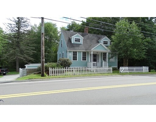
1043 West St
Wrentham, MA 02093
2 Weeks Ago
|
Edit
Favorites
1043 West St

Favorites
Check Back Soon for Upcoming Availability
| Beds | Baths | Average SF |
|---|---|---|
| 2 Bedrooms 2 Bedrooms 2 Br | 1 Bath 1 Bath 1 Ba | 1,330 SF |
Fees and Policies
The fees listed below are community-provided and may exclude utilities or add-ons. All payments are made directly to the property and are non-refundable unless otherwise specified.
Details
Utilities Included
-
Water
-
Trash Removal
-
Sewer
About This Property
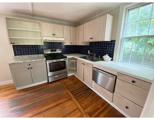
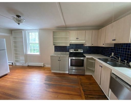
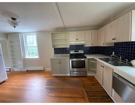
It doesn't get more charming than this historic 2 bedroom cape. You'll love sitting in your screened porch taking in the serenity of the 2 wooded acres this house sits on. On cooler nights cozy up in the finished basement complete with a wood burning stove. You'll have plenty of space for entertaining in the large living room and cooking won't be a problem in the nicely appointed kitchen. When you're ready to unwind there's a clawfoot tub waiting for you. If its shopping you're in the mood for the Wrentham Premium Outlets are just a short drive away. What are you waiting for? Schedule your appointment to come see this home today.
1043 West St is a house located in Norfolk County and the 02093 ZIP Code. This area is served by the Wrentham School District attendance zone.
House Features
- Dishwasher
- Range
- Refrigerator
- Fenced Lot
- Patio
- Garden
1043 West St,
Wrentham,
MA
02093
495-South is a large area surrounding Interstate 495 about 20 miles south of Boston. This suburban town features peaceful neighborhoods nestled in forested areas paired with commercial developments. Renters have the choice of moderately priced to luxury apartments, condos, and single-family homes. An abundance of shopping and dining choices are scattered along the town’s major thoroughfares. Ponds, creeks, and large natural areas like Franklin State Forest and DelCarte Conservation Area provide relaxing outdoor activities. Residents have access to big-city amenities by driving a bit north into Boston, and the eclectic downtown districts of Worcester and Framingham are situated outside of the western and eastern corners of town.
Learn more about living in 495-SouthBelow are rent ranges for similar nearby apartments
Amenities
- Dishwasher
- Range
- Refrigerator
- Fenced Lot
- Patio
- Garden
Expenses
Utilities Included
Water, Trash Removal, Sewer
Included
Education
| Colleges & Universities | Distance | ||
|---|---|---|---|
| Colleges & Universities | Distance | ||
| Drive: | 26 min | 13.9 mi | |
| Drive: | 23 min | 14.5 mi | |
| Drive: | 24 min | 15.9 mi | |
| Drive: | 27 min | 16.1 mi |
1043 West St is within 26 minutes or 13.9 miles from C.C. of Rhode Island, Flanagan. It is also near Wheaton College, Norton and Bryant University.
Schools


Public Elementary School
Grades PK-5
587 Students
Attendance Zone
Public Elementary School
Grades K-5
394 Students
Attendance Zone
Public Middle School
Grades 6-8
358 Students
Nearby
Public High School
Grades 9-12
1,100 Students
Nearby
Private Elementary & Middle School
Grades PK-8
368 Students
Nearby
Private Middle & High School
Grades 6-12
570 Students
Nearby
School data provided by
 The GreatSchools Rating helps parents compare schools within a state based on a variety of school quality indicators and provides a helpful picture of how effectively each school serves all of its students. Ratings are on a scale of 1 (below average) to 10 (above average) and can include test scores, college readiness, academic progress, advanced courses, equity, discipline and attendance data. We also advise parents to visit schools, consider other information on school performance and programs, and consider family needs as part of the school selection process.
View GreatSchools Rating Methodology
Data provided by GreatSchools.org © 2026. All rights reserved.
View GreatSchools Rating Methodology
Data provided by GreatSchools.org © 2026. All rights reserved.
Walkability Near 1043 West St Wrentham, MA 02093
Getting Around
 What do Walkability, Transit, Drivability, and Bikeability mean?
Walkability measures the walking distance to day-to-day needs.
Transit measures access to public transportation.
Drivability measures congestion, parking availability, and access to major roads.
Bikeability measures the suitability for cycling.
How It Works
What do Walkability, Transit, Drivability, and Bikeability mean?
Walkability measures the walking distance to day-to-day needs.
Transit measures access to public transportation.
Drivability measures congestion, parking availability, and access to major roads.
Bikeability measures the suitability for cycling.
How It Works
Somewhat Walkable
Walkability
20
/ 100
Minimal Public Transit
Transit
0
/ 100
Exceptionally Drivable
Drivability
100
/ 100
Somewhat Bikeable
Bikeability
20
/ 100
Scores provided by
-
Soundscore™
-
/ 100
Traffic
-Airport
-Businesses
-Scores provided by
HowLoud What is a Sound Score Rating? A Sound Score Rating aggregates noise caused by vehicle traffic, airplane traffic and local sources. How It WorksYou May Also Like
Similar Rentals Nearby
-
-

-

-

-

-

-

-
 3 Beds, 1 Bath, 1,200 sq ft$2,300Total Monthly Price12 Month LeaseTotal Monthly Price NewPrices include all required monthly fees.60 Concord St
 -
 2 Beds, 1 Bath, 872 sq ft$1,900Total Monthly PriceTotal Monthly Price NewPrices include all required monthly fees.2 Brook St
 -


What Are Walk Score®, Transit Score®, and Bike Score® Ratings?
Walk Score® measures the walkability of any address. Transit Score® measures access to public transit. Bike Score® measures the bikeability of any address.
What is a Sound Score Rating?
A Sound Score Rating aggregates noise caused by vehicle traffic, airplane traffic and local sources.

1043 West St
Wrentham, MA 02093