
$1,475
/ Month
1040 Neilson St Unit 2H
Far Rockaway, NY 11691
Favorites
1040 Neilson St Unit 2H

Favorites
Check Back Soon for Upcoming Availability
| Beds | Baths | Average SF |
|---|---|---|
| 1 Bedroom 1 Bedroom 1 Br | 1 Bath 1 Bath 1 Ba | 700 SF |
About This Property
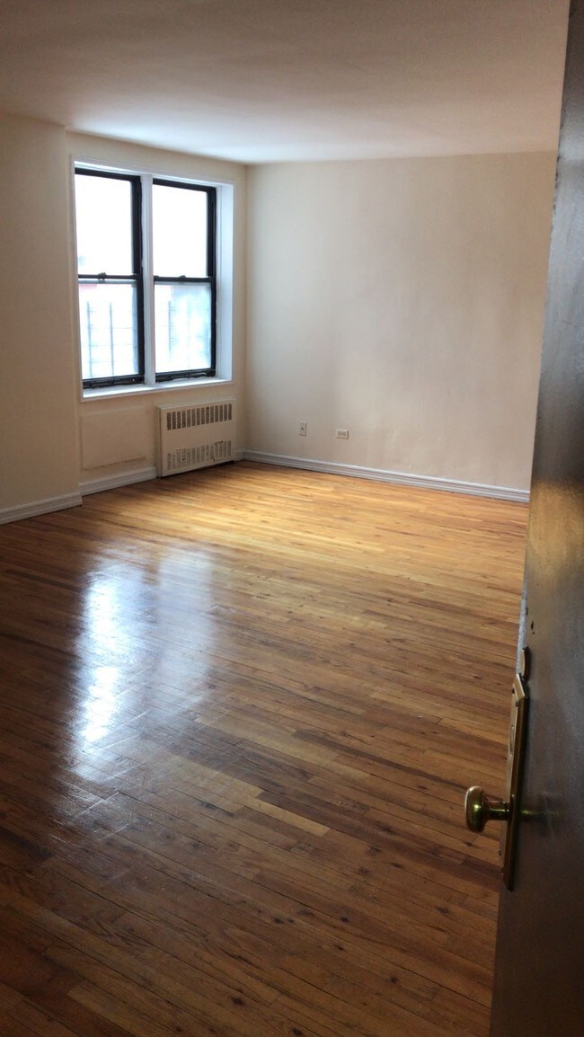
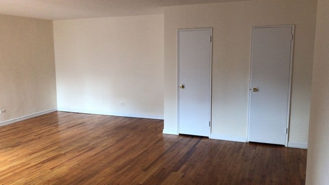
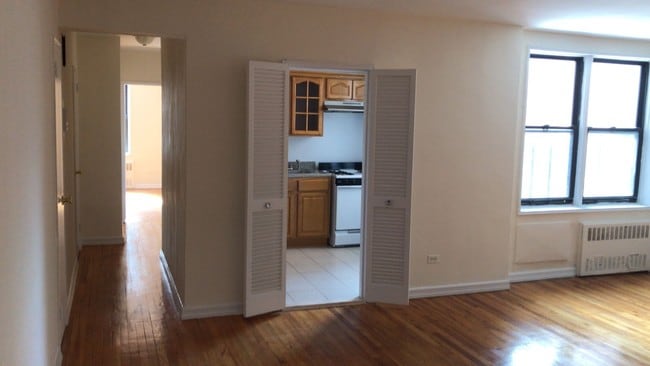
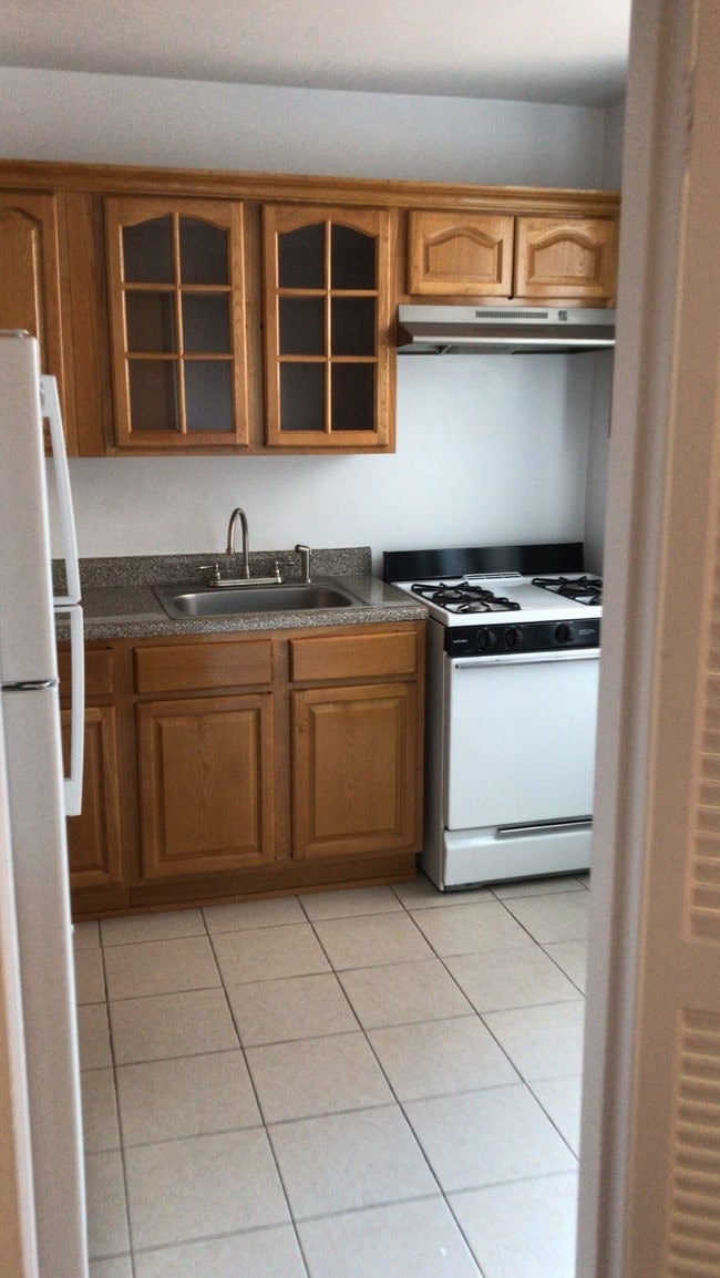
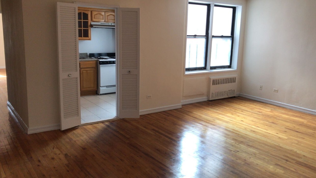
Beautiful apartment with a large bedroom, newly renovated kitchen, Plenty of closet space, Elevator and laundry building Very clean building, Live in super Heat, hot water and gas included.
1040 Neilson St is a condo located in Queens County and the 11691 ZIP Code. This area is served by the New York City Geographic District #27 attendance zone.
1040 Neilson
87 Units
7 Stories
Built in 1930
81,737 Sq Ft
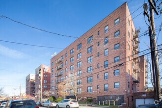
1040 Neilson Street is a seven-story condominium building located in the Far Rockaway neighborhood. Constructed in 1930, this brick structure houses 87 units and offers a straightforward, functional design. The building's flat roof and external fire escapes add to its practical appeal, making it a reliable choice for residents seeking comfort and convenience in a well-established community.
Learn more about 1040 Neilson
1040 Neilson St,
Far Rockaway,
NY
11691
Far Rockaway is nestled on the Rockaway Peninsula of Queens. Thriving with culture, you’ll find tons of diverse restaurants in this bustling community. For those who’ve always wanted a serene and suburban life but with proximity to Manhattan, Far Rockaway is the ideal place to live.
This coastal town draws tourists and vacationers from nearby boroughs. With convenient subway access from wherever, you’ll enjoy commuting with ease to and from work. In addition to many landscaped parks, Far Rockaway apartments are close to JFK Airport and the beach! Drive over the 878 Bridge to Atlantic Beach.
Learn more about living in Far RockawayBelow are rent ranges for similar nearby apartments
Education
| Colleges & Universities | Distance | ||
|---|---|---|---|
| Colleges & Universities | Distance | ||
| Drive: | 18 min | 8.1 mi | |
| Drive: | 18 min | 9.8 mi | |
| Drive: | 23 min | 11.0 mi | |
| Drive: | 24 min | 11.8 mi |
1040 Neilson St Unit 2H is within 18 minutes or 8.1 miles from York College. It is also near Molloy College and Adelphi University.
Schools


Public Elementary School
Grades K-5
959 Students
Attendance Zone
Public Middle & High School
Grades 6-12
596 Students
Nearby
Public Middle School
Grades 6-8
237 Students
Attendance Zone
Public Middle School
Grades 6-8
309 Students
Attendance Zone
Private Elementary & Middle School
Grades PK-8
290 Students
Nearby
Private Elementary & Middle School
Grades K-8
10 Students
Nearby
Private High School
Grades 9-12
339 Students
Nearby
School data provided by
 The GreatSchools Rating helps parents compare schools within a state based on a variety of school quality indicators and provides a helpful picture of how effectively each school serves all of its students. Ratings are on a scale of 1 (below average) to 10 (above average) and can include test scores, college readiness, academic progress, advanced courses, equity, discipline and attendance data. We also advise parents to visit schools, consider other information on school performance and programs, and consider family needs as part of the school selection process.
View GreatSchools Rating Methodology
Data provided by GreatSchools.org © 2026. All rights reserved.
View GreatSchools Rating Methodology
Data provided by GreatSchools.org © 2026. All rights reserved.
Transportation options available in Far Rockaway include Far Rockaway-Mott Avenue, located 0.5 mile from 1040 Neilson St Unit 2H. 1040 Neilson St Unit 2H is near John F Kennedy International, located 9.7 miles or 19 minutes away, and LaGuardia, located 15.4 miles or 28 minutes away.
| Transit / Subway | Distance | ||
|---|---|---|---|
| Transit / Subway | Distance | ||
|
|
Walk: | 10 min | 0.5 mi |
|
|
Drive: | 3 min | 1.2 mi |
|
|
Drive: | 4 min | 2.0 mi |
|
|
Drive: | 5 min | 2.5 mi |
|
|
Drive: | 6 min | 3.2 mi |
| Commuter Rail | Distance | ||
|---|---|---|---|
| Commuter Rail | Distance | ||
|
|
Walk: | 9 min | 0.5 mi |
|
|
Walk: | 14 min | 0.8 mi |
|
|
Drive: | 3 min | 1.2 mi |
|
|
Drive: | 5 min | 2.1 mi |
|
|
Drive: | 7 min | 3.3 mi |
| Airports | Distance | ||
|---|---|---|---|
| Airports | Distance | ||
|
John F Kennedy International
|
Drive: | 19 min | 9.7 mi |
|
LaGuardia
|
Drive: | 28 min | 15.4 mi |
Walkability Near 1040 Neilson St Far Rockaway, NY 11691
Getting Around
 What do Walkability, Transit, Drivability, and Bikeability mean?
Walkability measures the walking distance to day-to-day needs.
Transit measures access to public transportation.
Drivability measures congestion, parking availability, and access to major roads.
Bikeability measures the suitability for cycling.
How It Works
What do Walkability, Transit, Drivability, and Bikeability mean?
Walkability measures the walking distance to day-to-day needs.
Transit measures access to public transportation.
Drivability measures congestion, parking availability, and access to major roads.
Bikeability measures the suitability for cycling.
How It Works
Very Walkable
Walkability
80
/ 100
Good Public Transit
Transit
60
/ 100
Somewhat Drivable
Drivability
30
/ 100
Moderately Bikeable
Bikeability
60
/ 100
Scores provided by
-
Soundscore™
-
/ 100
Traffic
-Airport
-Businesses
-Scores provided by
HowLoud What is a Sound Score Rating? A Sound Score Rating aggregates noise caused by vehicle traffic, airplane traffic and local sources. How It WorksTime and distance from 1040 Neilson St Unit 2H.
| Shopping Centers | Distance | ||
|---|---|---|---|
| Shopping Centers | Distance | ||
| Drive: | 4 min | 1.5 mi | |
| Drive: | 5 min | 1.8 mi | |
| Drive: | 4 min | 2.0 mi |
1040 Neilson St Unit 2H has 3 shopping centers within 2.0 miles, which is about a 4-minute drive. The miles and minutes will be for the farthest away property.
| Parks and Recreation | Distance | ||
|---|---|---|---|
| Parks and Recreation | Distance | ||
|
Bayswater Point State Park
|
Drive: | 4 min | 1.7 mi |
|
Bayswater Park
|
Drive: | 5 min | 2.2 mi |
|
Rockaway Community Park
|
Drive: | 7 min | 3.1 mi |
|
Brookville Park
|
Drive: | 11 min | 4.5 mi |
|
Rockaway Beach and Boardwalk
|
Drive: | 9 min | 4.9 mi |
1040 Neilson St Unit 2H has 5 parks within 4.9 miles, including Bayswater Park, Bayswater Point State Park, and Rockaway Community Park.
| Hospitals | Distance | ||
|---|---|---|---|
| Hospitals | Distance | ||
| Walk: | 11 min | 0.6 mi | |
| Drive: | 18 min | 9.2 mi | |
| Drive: | 17 min | 9.2 mi |
1040 Neilson St Unit 2H has 3 hospitals within 9.2 miles, the nearest is St. John's Episcopal Hospital at South Shore which is 0.6 mile away and a 11 minute walk.
| Military Bases | Distance | ||
|---|---|---|---|
| Military Bases | Distance | ||
| Drive: | 17 min | 8.9 mi | |
| Drive: | 20 min | 10.1 mi | |
| Drive: | 28 min | 11.6 mi |
1040 Neilson St Unit 2H has 3 military bases within 11.6 miles, the nearest is US Coast Guard which is 8.9 miles away and a 17 minute drive.
You May Also Like
Similar Rentals Nearby


What Are Walk Score®, Transit Score®, and Bike Score® Ratings?
Walk Score® measures the walkability of any address. Transit Score® measures access to public transit. Bike Score® measures the bikeability of any address.
What is a Sound Score Rating?
A Sound Score Rating aggregates noise caused by vehicle traffic, airplane traffic and local sources.
1040 Neilson St
Far Rockaway, NY 11691