
1030 Harrison Ave
West Collingswood, NJ 08107
Favorites
1030 Harrison Ave

Favorites
Check Back Soon for Upcoming Availability
| Beds | Baths | Average SF |
|---|---|---|
| 2 Bedrooms 2 Bedrooms 2 Br | 1 Bath 1 Bath 1 Ba | 907 SF |
About This Property
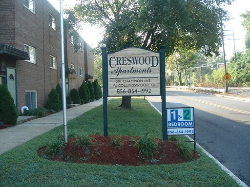
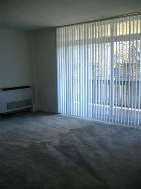
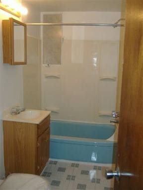
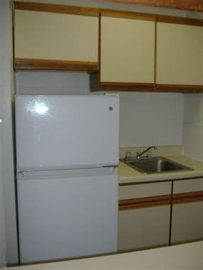
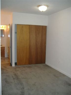
Nestled in historic Collingswood, New Jersey, Creswood Apartments is a place you would be proud to call home. Great location- located just off Rt 130 South, and minutes from the Ben Franklin and Walt Whitman bridges, and the Patco High-Speed line. Creswood offers affordable prices and spacious apartments, with modern kitchens, extra large closets and a fenced in court yard.
1030 Harrison Ave is a house located in Camden County and the 08107 ZIP Code. This area is served by the Magnolia attendance zone.
Location
Get Directions
Cherry Hill is a close-knit community located 8 miles southeast of Philadelphia. Haddonfield, its neighbor immediately south, creates the border between the two towns. With a preserved historic district teeming with Victorian, colonial and federal-period houses, it's no wonder that Philadelphia Magazine chose Haddonfield as one of the best places to live in the Delaware Valley.
The close proximity to the city combined with safe neighborhoods, excellent school systems, and all the charm living in a historic town brings, checking out the area is a no-brainer to those contemplating a move in the area.
Learn more about living in Cherry Hill/HaddonfieldBelow are rent ranges for similar nearby apartments
| Beds | Average Size | Lowest | Typical | Premium |
|---|---|---|---|---|
| Studio Studio Studio | 549-552 Sq Ft | $1,165 | $1,990 | $3,445 |
| 1 Bed 1 Bed 1 Bed | 798-800 Sq Ft | $742 | $2,092 | $5,940 |
| 2 Beds 2 Beds 2 Beds | 1073-1074 Sq Ft | $1,158 | $2,536 | $6,840 |
| 3 Beds 3 Beds 3 Beds | 1518 Sq Ft | $1,287 | $3,301 | $6,240 |
| 4 Beds 4 Beds 4 Beds | 2424 Sq Ft | $2,850 | $4,201 | $7,500 |
Education
| Colleges & Universities | Distance | ||
|---|---|---|---|
| Colleges & Universities | Distance | ||
| Drive: | 13 min | 7.3 mi | |
| Drive: | 15 min | 8.5 mi | |
| Drive: | 16 min | 11.4 mi | |
| Drive: | 17 min | 11.8 mi |
1030 Harrison Ave is within 13 minutes or 7.3 miles from Camden Co. Coll., Blackwood. It is also near Gloucester County College and Camden Co. Coll., Camden City.
Schools


Public Elementary & Middle School
Grades PK-8
388 Students
Attendance Zone
Public High School
Grades 9-12
894 Students
Attendance Zone
Private Elementary, Middle & High School
Grades 1-12
Nearby
Private Elementary & Middle School
Grades PK-8
136 Students
Nearby
School data provided by
 The GreatSchools Rating helps parents compare schools within a state based on a variety of school quality indicators and provides a helpful picture of how effectively each school serves all of its students. Ratings are on a scale of 1 (below average) to 10 (above average) and can include test scores, college readiness, academic progress, advanced courses, equity, discipline and attendance data. We also advise parents to visit schools, consider other information on school performance and programs, and consider family needs as part of the school selection process.
View GreatSchools Rating Methodology
Data provided by GreatSchools.org © 2025. All rights reserved.
View GreatSchools Rating Methodology
Data provided by GreatSchools.org © 2025. All rights reserved.
Transportation options available in West Collingswood include Ashland, located 2.2 miles from 1030 Harrison Ave. 1030 Harrison Ave is near Philadelphia International, located 17.7 miles or 29 minutes away, and Trenton Mercer, located 41.5 miles or 57 minutes away.
| Transit / Subway | Distance | ||
|---|---|---|---|
| Transit / Subway | Distance | ||
|
|
Drive: | 4 min | 2.2 mi |
|
|
Drive: | 8 min | 3.4 mi |
|
|
Drive: | 6 min | 3.6 mi |
|
|
Drive: | 7 min | 4.5 mi |
|
|
Drive: | 9 min | 5.8 mi |
| Commuter Rail | Distance | ||
|---|---|---|---|
| Commuter Rail | Distance | ||
|
|
Drive: | 6 min | 3.6 mi |
|
|
Drive: | 13 min | 7.6 mi |
|
|
Drive: | 14 min | 10.5 mi |
| Drive: | 20 min | 11.3 mi | |
|
|
Drive: | 21 min | 13.8 mi |
| Airports | Distance | ||
|---|---|---|---|
| Airports | Distance | ||
|
Philadelphia International
|
Drive: | 29 min | 17.7 mi |
|
Trenton Mercer
|
Drive: | 57 min | 41.5 mi |
Time and distance from 1030 Harrison Ave.
| Shopping Centers | Distance | ||
|---|---|---|---|
| Shopping Centers | Distance | ||
| Walk: | 16 min | 0.9 mi | |
| Walk: | 19 min | 1.0 mi | |
| Drive: | 2 min | 1.5 mi |
1030 Harrison Ave has 3 shopping centers within 1.5 miles, which is about a 2-minute walk. The miles and minutes will be for the farthest away property.
| Parks and Recreation | Distance | ||
|---|---|---|---|
| Parks and Recreation | Distance | ||
|
Downs Farms Trails
|
Drive: | 5 min | 2.8 mi |
|
Croft Farm Nature Trail
|
Drive: | 9 min | 5.5 mi |
|
Kresson Nature Trails
|
Drive: | 11 min | 5.7 mi |
|
Erlton North Trails
|
Drive: | 12 min | 7.1 mi |
|
Barclay Farmstead Nature Trail
|
Drive: | 13 min | 7.5 mi |
1030 Harrison Ave has 5 parks within 7.5 miles, including Downs Farms Trails, Croft Farm Nature Trail, and Kresson Nature Trails.
| Hospitals | Distance | ||
|---|---|---|---|
| Hospitals | Distance | ||
| Drive: | 5 min | 3.4 mi | |
| Drive: | 11 min | 6.5 mi | |
| Drive: | 16 min | 8.4 mi |
1030 Harrison Ave has 3 hospitals within 8.4 miles, the nearest is Jefferson Stratford Hospital which is 3.4 miles away and a 5 minute drive.
| Military Bases | Distance | ||
|---|---|---|---|
| Military Bases | Distance | ||
| Drive: | 20 min | 12.8 mi |
1030 Harrison Ave is 12.8 miles and a 20 minute drive from Philadelphia Naval Busi Center.
You May Also Like
Similar Rentals Nearby


What Are Walk Score®, Transit Score®, and Bike Score® Ratings?
Walk Score® measures the walkability of any address. Transit Score® measures access to public transit. Bike Score® measures the bikeability of any address.
What is a Sound Score Rating?
A Sound Score Rating aggregates noise caused by vehicle traffic, airplane traffic and local sources

1030 Harrison Ave
West Collingswood, NJ 08107