
The Riverdale Tower
3745 Riverdale Ave,
The Bronx, NY 10463
$2,200 - $4,500
Studio - 2 Beds
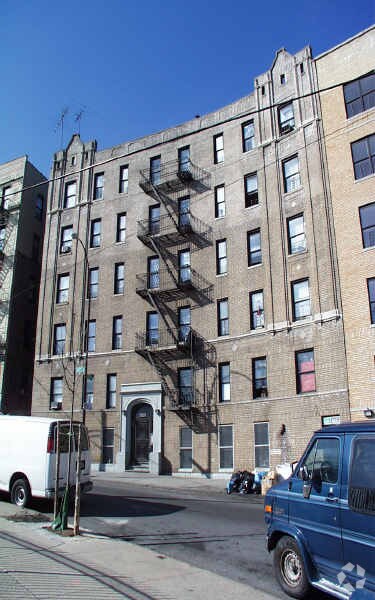

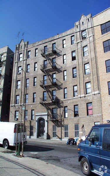
Discover 1029 Hall Pl in Bronx. The location in Bronx's 10459 area has much to offer its residents. The knowledgeable leasing staff is waiting to show you all that this community has in store. Schedule a time to view the available floorplans. It's time to love where you live. Stop by for a visit today.
1029 Hall Pl is an apartment community located in Bronx County and the 10459 ZIP Code. This area is served by the New York City Geographic District #12 attendance zone.
Foxhurst is a neighborhood in the South Bronx. This urban neighborhood boasts an excellent location, located on the west side of Interstate 278 and the Bronx River about six miles from Manhattan. Foxhurst is roughly two miles east of the Yankee Stadium and the Bronx Museum of the Arts. Bronx Park, home of the Bronx Zoo and the New York Botanical Garden, is two miles north of Foxhurst as well. Along with the highway, Foxhurst has several subway stations making traveling throughout the Big Apple easier.
Foxhurst encompasses what you'll find in most Bronx neighborhoods: brick apartments above street-level storefronts, wide sidewalks crowded with pedestrians, bodegas, international restaurants, and iron fire escapes cascading down the sides of historic buildings. You'll also discover a few surprises, like the beauty of Concrete Plant Park, a former concrete plant-turned- riverfront park.
Learn more about living in FoxhurstCompare neighborhood and city base rent averages by bedroom.
| Foxhurst | Bronx, NY | |
|---|---|---|
| Studio | $1,363 | $1,613 |
| 1 Bedroom | $1,511 | $1,636 |
| 2 Bedrooms | $1,632 | $2,098 |
| 3 Bedrooms | $1,423 | $2,358 |
| Colleges & Universities | Distance | ||
|---|---|---|---|
| Colleges & Universities | Distance | ||
| Drive: | 6 min | 2.1 mi | |
| Drive: | 9 min | 3.4 mi | |
| Drive: | 10 min | 3.6 mi | |
| Drive: | 9 min | 3.6 mi |


Transportation options available in Bronx include Intervale Avenue, located 0.2 mile from 1029 Hall Pl. 1029 Hall Pl is near LaGuardia, located 7.8 miles or 17 minutes away, and John F Kennedy International, located 18.8 miles or 29 minutes away.
| Transit / Subway | Distance | ||
|---|---|---|---|
| Transit / Subway | Distance | ||
|
|
Walk: | 4 min | 0.2 mi |
|
|
Walk: | 5 min | 0.3 mi |
|
|
Walk: | 8 min | 0.4 mi |
|
|
Walk: | 10 min | 0.6 mi |
|
|
Walk: | 11 min | 0.6 mi |
| Commuter Rail | Distance | ||
|---|---|---|---|
| Commuter Rail | Distance | ||
|
|
Drive: | 4 min | 1.2 mi |
|
|
Drive: | 6 min | 2.2 mi |
|
|
Drive: | 11 min | 3.8 mi |
|
|
Drive: | 8 min | 3.9 mi |
| Drive: | 9 min | 3.9 mi |
| Airports | Distance | ||
|---|---|---|---|
| Airports | Distance | ||
|
LaGuardia
|
Drive: | 17 min | 7.8 mi |
|
John F Kennedy International
|
Drive: | 29 min | 18.8 mi |
Scores provided by
Traffic
-Airport
-Businesses
-Scores provided by
HowLoud What is a Sound Score Rating? A Sound Score Rating aggregates noise caused by vehicle traffic, airplane traffic and local sources. How It WorksTime and distance from 1029 Hall Pl.
| Shopping Centers | Distance | ||
|---|---|---|---|
| Shopping Centers | Distance | ||
| Walk: | 21 min | 1.1 mi | |
| Drive: | 3 min | 1.4 mi |
| Parks and Recreation | Distance | ||
|---|---|---|---|
| Parks and Recreation | Distance | ||
|
Captain Rivera Playground
|
Walk: | 14 min | 0.7 mi |
|
Concrete Plant Park
|
Drive: | 4 min | 1.3 mi |
|
St. Mary's Park
|
Drive: | 3 min | 1.3 mi |
|
Crotona Park
|
Drive: | 4 min | 1.5 mi |
|
Starlight Park
|
Drive: | 5 min | 1.5 mi |
| Hospitals | Distance | ||
|---|---|---|---|
| Hospitals | Distance | ||
| Walk: | 16 min | 0.8 mi | |
| Drive: | 4 min | 1.7 mi | |
| Drive: | 9 min | 2.9 mi |
| Military Bases | Distance | ||
|---|---|---|---|
| Military Bases | Distance | ||
| Drive: | 19 min | 9.3 mi | |
| Drive: | 30 min | 14.5 mi | |
| Drive: | 39 min | 24.4 mi |
What Are Walk Score®, Transit Score®, and Bike Score® Ratings?
Walk Score® measures the walkability of any address. Transit Score® measures access to public transit. Bike Score® measures the bikeability of any address.
What is a Sound Score Rating?
A Sound Score Rating aggregates noise caused by vehicle traffic, airplane traffic and local sources.
1029 Hall Pl
Bronx, NY 10459


