

$2,300
/ Month
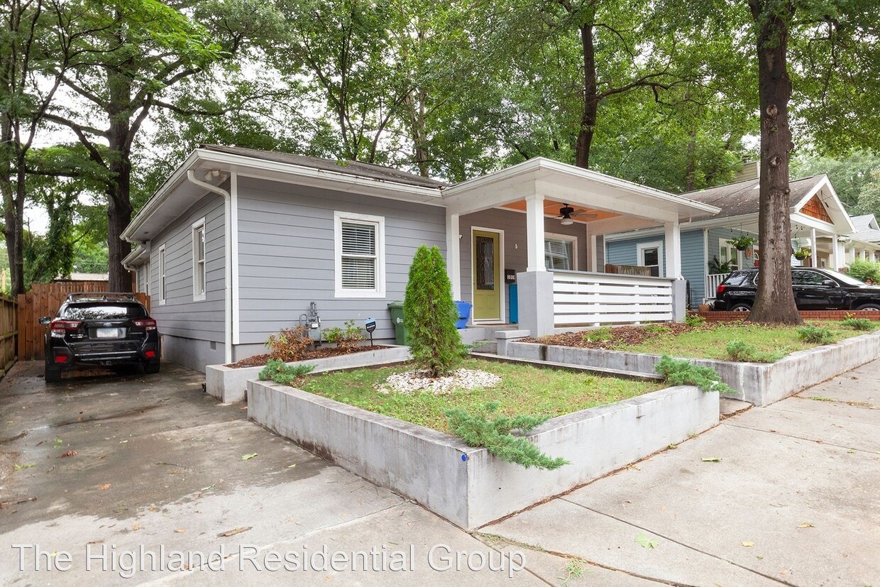
1019 Parsons St SW
Atlanta, GA 30314
2 Weeks Ago
|
Edit
Favorites
1019 Parsons St SW

Favorites
Check Back Soon for Upcoming Availability
| Beds | Baths | Average SF |
|---|---|---|
| 3 Bedrooms 3 Bedrooms 3 Br | 2 Baths 2 Baths 2 Ba | 1,311 SF |
Fees and Policies
The fees below are based on community-supplied data and may exclude additional fees and utilities.
- Dogs Allowed
-
Fees not specified
-
Weight limit--
-
Pet Limit--
About This Property
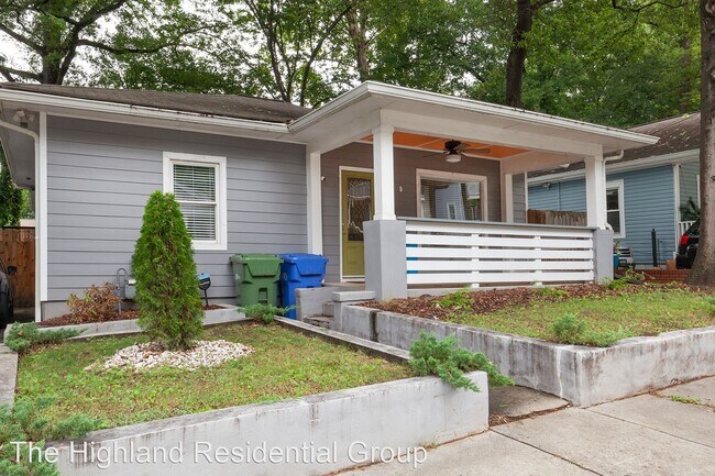
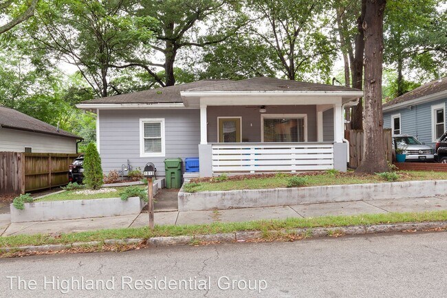
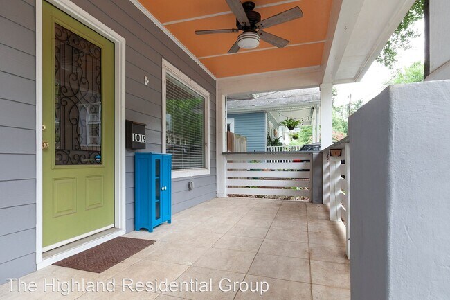
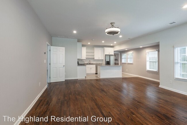
- Beautifully Updated 3/2 w/ Large Fenced-In Backyard w/ Deck and Patio! - On a quiet street and minutes from I-20, I-75/85 and Marta, this 3bd/2ba home is perfect for families commuting in and around the city. And just a few miles from Morehouse, Spellman College, Georgia State, this property is also great for roommates looking to share space. This location also provides countless options for recreation and entertainment such as the Georgia Aquarium, Mercedes Benz Stadium, Westside Reservoir Park, and Atlanta Beltline’s Westside Trails, Boxcar at Hop City, Slutty Vegan ATL, and Rosie's Cafe just to name a few. This home also features hardwoods throughout, a kitchen with plenty of cabinet space and center island, gorgeous granite countertops, stainless-steel appliances, an spacious and open living/dining room space, a good size master bedroom with a beautifully tiled stand-in master bath, two guest rooms w/ full hall bath w/ shower/tub combo, ceiling fans throughout, a peaceful front porch, an AWESOME fully fenced backyard w/ large rear deck and patio, and storage shed, and off-street parking. The Highland Residential Group, LLC (RLNE8174518) Pet policies: Small Dogs Allowed, Cats Allowed, Large Dogs Allowed.
1019 Parsons St SW is a house located in Fulton County and the 30314 ZIP Code. This area is served by the Atlanta Public Schools attendance zone.
Location
Get Directions
Located just southwest of Downtown Atlanta, the West End is a historic neighborhood home to charming residences and a vibrant community. The West End’s cultural amenities extend beyond its many exciting, diverse restaurants. The neighborhood is also home to the Hammond House Museum and the Wren’s Nest, where residents can delve into the area’s storied, artistic past.
The West End community comes together for an array of community meetings and festivals. Options for outdoor recreation abound at West End Park, Howell Park, and the Atlanta Beltline’s Westside Trail, which cuts directly through the neighborhood. There are plenty excellent shopping opportunities at the Mall at West End as well.
The West End’s convenient, in-town location is a major draw for many neighborhood residents. Morehouse College, Spelman College, Clark Atlanta University, and Morris Brown College are all close by.
Learn more about living in West EndBelow are rent ranges for similar nearby apartments
Education
| Colleges & Universities | Distance | ||
|---|---|---|---|
| Colleges & Universities | Distance | ||
| Walk: | 11 min | 0.6 mi | |
| Walk: | 12 min | 0.6 mi | |
| Walk: | 20 min | 1.1 mi | |
| Drive: | 4 min | 1.2 mi |
1019 Parsons St SW is within 11 minutes or 0.6 mile from Clark Atlanta University. It is also near Morehouse College and Spelman College.
Schools


Public Elementary School
Grades PK-5
461 Students
Attendance Zone
Public Middle School
Grades 6-8
399 Students
Attendance Zone
Public High School
Grades 9-12
831 Students
Attendance Zone
Private Elementary School
Grades PK-5
48 Students
Nearby
Private Elementary, Middle & High School
Grades 3-10
7 Students
Nearby
Private Middle & High School
Grades 6-12
Nearby
School data provided by
 The GreatSchools Rating helps parents compare schools within a state based on a variety of school quality indicators and provides a helpful picture of how effectively each school serves all of its students. Ratings are on a scale of 1 (below average) to 10 (above average) and can include test scores, college readiness, academic progress, advanced courses, equity, discipline and attendance data. We also advise parents to visit schools, consider other information on school performance and programs, and consider family needs as part of the school selection process.
View GreatSchools Rating Methodology
Data provided by GreatSchools.org © 2025. All rights reserved.
View GreatSchools Rating Methodology
Data provided by GreatSchools.org © 2025. All rights reserved.
Transportation options available in Atlanta include Ashby, located 0.6 mile from 1019 Parsons St SW. 1019 Parsons St SW is near Hartsfield - Jackson Atlanta International, located 11.0 miles or 18 minutes away.
| Transit / Subway | Distance | ||
|---|---|---|---|
| Transit / Subway | Distance | ||
|
|
Walk: | 11 min | 0.6 mi |
|
|
Drive: | 3 min | 1.3 mi |
|
|
Drive: | 3 min | 1.6 mi |
|
|
Drive: | 4 min | 1.8 mi |
|
|
Drive: | 4 min | 1.9 mi |
| Commuter Rail | Distance | ||
|---|---|---|---|
| Commuter Rail | Distance | ||
|
|
Drive: | 11 min | 5.5 mi |
| Airports | Distance | ||
|---|---|---|---|
| Airports | Distance | ||
|
Hartsfield - Jackson Atlanta International
|
Drive: | 18 min | 11.0 mi |
Time and distance from 1019 Parsons St SW.
| Shopping Centers | Distance | ||
|---|---|---|---|
| Shopping Centers | Distance | ||
| Walk: | 14 min | 0.7 mi | |
| Walk: | 18 min | 0.9 mi | |
| Walk: | 19 min | 1.0 mi |
1019 Parsons St SW has 3 shopping centers within 1.0 miles, which is about a 19-minute walk. The miles and minutes will be for the farthest away property.
| Parks and Recreation | Distance | ||
|---|---|---|---|
| Parks and Recreation | Distance | ||
|
Park Pride
|
Drive: | 4 min | 2.2 mi |
|
Georgia Aquarium
|
Drive: | 5 min | 2.6 mi |
|
The Georgia Capitol Museum
|
Drive: | 5 min | 2.6 mi |
|
West Atlanta Watershed Alliance (WAWA)
|
Drive: | 6 min | 2.9 mi |
|
Imagine It! The Children's Museum of Atlanta
|
Drive: | 6 min | 2.9 mi |
1019 Parsons St SW has 5 parks within 2.9 miles, including Park Pride, West Atlanta Watershed Alliance (WAWA), and The Georgia Capitol Museum.
| Hospitals | Distance | ||
|---|---|---|---|
| Hospitals | Distance | ||
| Drive: | 6 min | 2.8 mi | |
| Drive: | 6 min | 3.3 mi | |
| Drive: | 7 min | 3.7 mi |
1019 Parsons St SW has 3 hospitals within 3.7 miles, the nearest is Grady Memorial Hospital which is 2.8 miles away and a 6 minute drive.
| Military Bases | Distance | ||
|---|---|---|---|
| Military Bases | Distance | ||
| Drive: | 8 min | 3.9 mi | |
| Drive: | 26 min | 14.3 mi |
1019 Parsons St SW is 3.9 miles from Fort McPherson, and is convenient to other military bases, including Fort Gillem.
You May Also Like
Similar Rentals Nearby
-
-

-
-
-
-
1 / 58

-
-
-
-


What Are Walk Score®, Transit Score®, and Bike Score® Ratings?
Walk Score® measures the walkability of any address. Transit Score® measures access to public transit. Bike Score® measures the bikeability of any address.
What is a Sound Score Rating?
A Sound Score Rating aggregates noise caused by vehicle traffic, airplane traffic and local sources
1019 Parsons St SW
Atlanta, GA 30314