


$1,450
/ Month
1015 W Moody Ln
Crestwood, KY 40014
Favorites
1015 W Moody Ln

Favorites
Check Back Soon for Upcoming Availability
| Beds | Baths | Average SF |
|---|---|---|
| 3 Bedrooms 3 Bedrooms 3 Br | 1 Bath 1 Bath 1 Ba | 1,012 SF |
About This Property
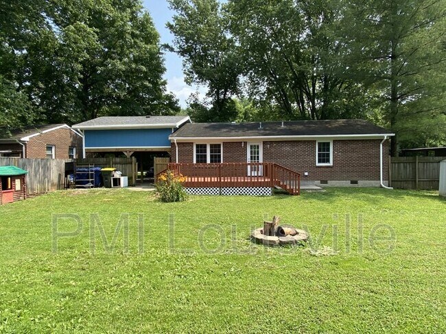
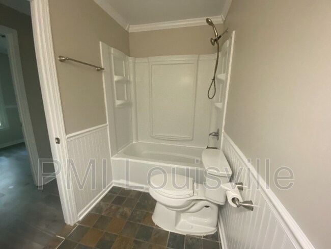
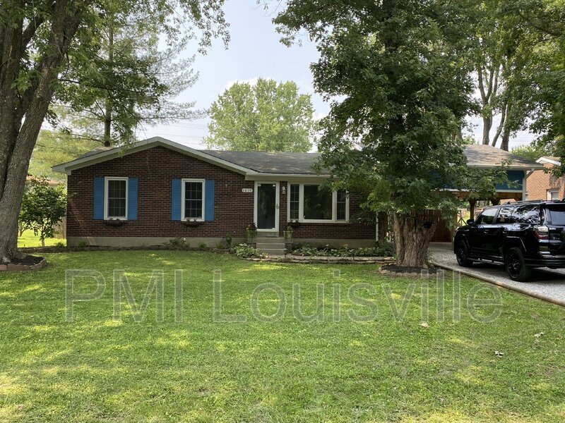
Welcome home to your new house! Wow this one is nice! 3 bedrooms, 1 full bath. Upgraded appliances and flooring, fenced in backyard, covered parking, firepit, large deck and patio! Oldham County Schools close to Buckner, Lagrange and Ballardsville!
1015 W Moody Ln is a house located in Oldham County and the 40014 ZIP Code. This area is served by the Oldham County School District attendance zone.
1015 W Moody Ln,
Crestwood,
KY
40014
Education
| Colleges & Universities | Distance | ||
|---|---|---|---|
| Colleges & Universities | Distance | ||
| Drive: | 29 min | 19.0 mi | |
| Drive: | 35 min | 22.8 mi | |
| Drive: | 35 min | 24.5 mi | |
| Drive: | 39 min | 27.3 mi |
1015 W Moody Ln is within 29 minutes or 19.0 miles from University of Louisville. It is also near Southern Baptist Seminary and Sullivan University.
Schools


Public Elementary School
Grades PK-5
780 Students
Nearby
Public Elementary School
Grades K-5
521 Students
Attendance Zone
Public Middle School
Grades 6-8
564 Students
Attendance Zone
Public High School
Grades 9-12
1,505 Students
Attendance Zone
Private Elementary, Middle & High School
Grades K-12
Nearby
Private Elementary, Middle & High School
Grades K-12
Nearby
Private Elementary & Middle School
Grades PK-8
483 Students
Nearby
Private Elementary & Middle School
Grades K-8
Nearby
School data provided by
 The GreatSchools Rating helps parents compare schools within a state based on a variety of school quality indicators and provides a helpful picture of how effectively each school serves all of its students. Ratings are on a scale of 1 (below average) to 10 (above average) and can include test scores, college readiness, academic progress, advanced courses, equity, discipline and attendance data. We also advise parents to visit schools, consider other information on school performance and programs, and consider family needs as part of the school selection process.
View GreatSchools Rating Methodology
Data provided by GreatSchools.org © 2026. All rights reserved.
View GreatSchools Rating Methodology
Data provided by GreatSchools.org © 2026. All rights reserved.
Walkability Near 1015 W Moody Ln Crestwood, KY 40014
Getting Around
 What do Walkability, Transit, Drivability, and Bikeability mean?
Walkability measures the walking distance to day-to-day needs.
Transit measures access to public transportation.
Drivability measures congestion, parking availability, and access to major roads.
Bikeability measures the suitability for cycling.
How It Works
What do Walkability, Transit, Drivability, and Bikeability mean?
Walkability measures the walking distance to day-to-day needs.
Transit measures access to public transportation.
Drivability measures congestion, parking availability, and access to major roads.
Bikeability measures the suitability for cycling.
How It Works
Not Walkable
Walkability
10
/ 100
Exceptionally Drivable
Drivability
90
/ 100
Somewhat Bikeable
Bikeability
20
/ 100
Scores provided by
-
Soundscore™
-
/ 100
Traffic
-Airport
-Businesses
-Scores provided by
HowLoud What is a Sound Score Rating? A Sound Score Rating aggregates noise caused by vehicle traffic, airplane traffic and local sources. How It WorksYou May Also Like
Similar Rentals Nearby


What Are Walk Score®, Transit Score®, and Bike Score® Ratings?
Walk Score® measures the walkability of any address. Transit Score® measures access to public transit. Bike Score® measures the bikeability of any address.
What is a Sound Score Rating?
A Sound Score Rating aggregates noise caused by vehicle traffic, airplane traffic and local sources.
1015 W Moody Ln
Crestwood, KY 40014