
$7,500 / Month
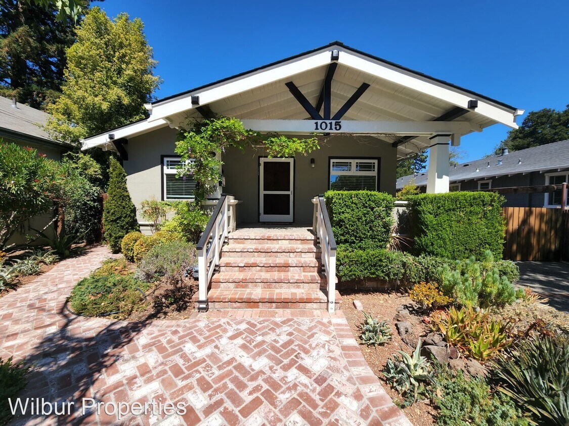
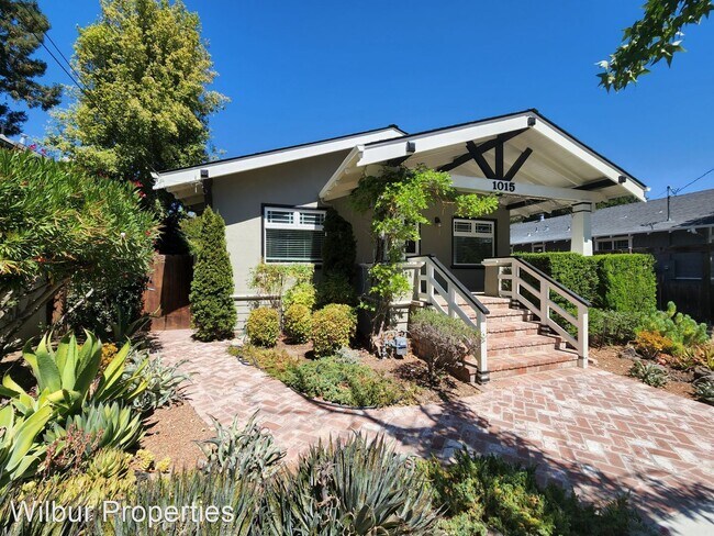
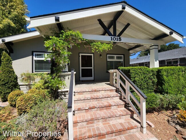
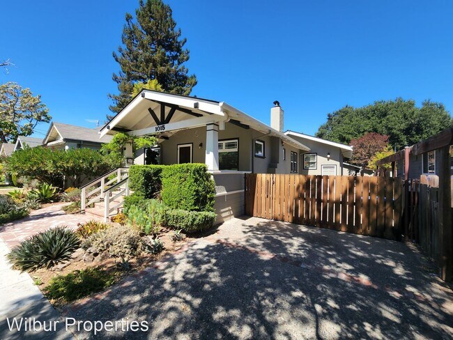
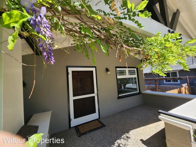
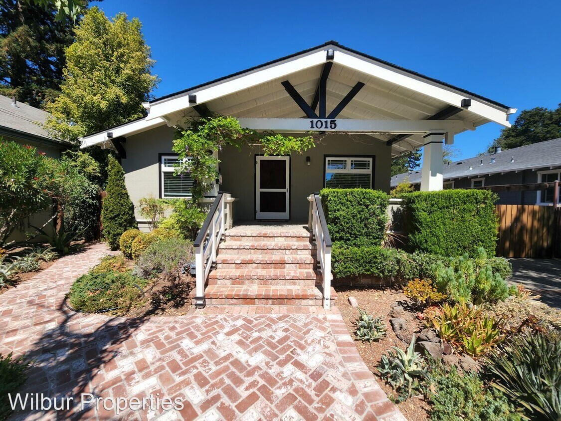
1015 High St
Palo Alto, CA 94301
2 Weeks Ago
Favorites
1015 High St

Favorites
Check Back Soon for Upcoming Availability
| Beds | Baths | Average SF |
|---|---|---|
| 4 Bedrooms 4 Bedrooms 4 Br | 4 Baths 4 Baths 4 Ba | 2,526 SF |
Fees and Policies
The fees below are based on community-supplied data and may exclude additional fees and utilities.
About This Property
- Beautiful and Updated Home in Downtown Palo Alto with central AC! - This gorgeous property features new interior and exterior paint, new flooring throughout, and a studio unit in the backyard! The spacious floor plan of the main level consists of two bedrooms, two bathrooms, a dining room with built-in cabinetry and kitchen. The kitchen is roomy with a center island and generous counterspace. It features large windows and skylights for an abundance of natural sunlight. On the next floor is one bedroom, a bathroom, and a second large living room with walk-in closets. 1015 High Street has new hardwood flooring throughout the main floor level and carpet downstairs. Central heat & AC. The back yard is charming with newly stained decks and a hot tub! The studio cottage is updated with a full bathroom, and located in the backyard, separate from the main house. This prime location is a couple blocks away from downtown Palo Alto. Enjoy living minutes away from shops, restaurants, and lovely parks. Close proximity to Caltrain offers alternative transportation. Gardener Included. Tenant is responsible for all utilities. This property is professionally managed by Wilbur Properties, BRE #00823559. (RLNE7676337) Other Amenities: Other (adu). Appliances: Air Conditioning, Washer & Dryer.
1015 High St is a house located in Santa Clara County and the 94301 ZIP Code. This area is served by the Palo Alto Unified attendance zone.
Unique Features
- Amenities - adu
House Features
- Washer/Dryer
- Air Conditioning
Location
Get Directions
An outgoing vibe emanates from the Downtown North neighborhood. Downtown North provides an energy like no other in Palo Alto. Still, locals enjoy being part of a tight-knit community focused on safety, communication and most importantly: fun.
Palo Alto has one of the best public school systems in California, houses Stanford University, and has some of the most delicious dining and exciting shopping opportunities in the Bay Area. The placement of the city provides convenience for commuters to San Jose 24 miles to the Southeast or San Francisco 32 miles to the Northwest.
Learn more about living in Downtown Palo AltoBelow are rent ranges for similar nearby apartments
| Beds | Average Size | Lowest | Typical | Premium |
|---|---|---|---|---|
| Studio Studio Studio | 490 Sq Ft | $2,500 | $3,649 | $4,070 |
| 1 Bed 1 Bed 1 Bed | 635-640 Sq Ft | $2,350 | $4,074 | $5,490 |
| 2 Beds 2 Beds 2 Beds | 922 Sq Ft | $4,250 | $6,215 | $13,190 |
| 3 Beds 3 Beds 3 Beds | 1855 Sq Ft | $7,600 | $8,275 | $8,950 |
| 4 Beds 4 Beds 4 Beds | 2710 Sq Ft | $11,000 | $13,000 | $15,000 |
Amenities
- Washer/Dryer
- Air Conditioning
- Amenities - adu
Education
| Colleges & Universities | Distance | ||
|---|---|---|---|
| Colleges & Universities | Distance | ||
| Drive: | 6 min | 2.0 mi | |
| Drive: | 7 min | 2.7 mi | |
| Drive: | 10 min | 3.9 mi | |
| Drive: | 15 min | 8.3 mi |
1015 High St is within 6 minutes or 2.0 miles from Stanford University. It is also near Menlo College and Foothill College, Middlefield.
Schools


Public Elementary School
Grades K-5
367 Students
Nearby
Public Elementary School
Grades K-5
331 Students
Attendance Zone
Public Middle School
Grades 6-8
755 Students
Attendance Zone
Public High School
Grades 9-12
1,992 Students
Attendance Zone
Private Elementary & Middle School
Grades PK-8
Nearby
Private Middle & High School
Grades 6-12
430 Students
Nearby
School data provided by
 The GreatSchools Rating helps parents compare schools within a state based on a variety of school quality indicators and provides a helpful picture of how effectively each school serves all of its students. Ratings are on a scale of 1 (below average) to 10 (above average) and can include test scores, college readiness, academic progress, advanced courses, equity, discipline and attendance data. We also advise parents to visit schools, consider other information on school performance and programs, and consider family needs as part of the school selection process.
View GreatSchools Rating Methodology
Data provided by GreatSchools.org © 2025. All rights reserved.
View GreatSchools Rating Methodology
Data provided by GreatSchools.org © 2025. All rights reserved.
Transportation options available in Palo Alto include Mountain View Station, located 5.4 miles from 1015 High St. 1015 High St is near Norman Y Mineta San Jose International, located 15.0 miles or 23 minutes away, and San Francisco International, located 20.9 miles or 30 minutes away.
| Transit / Subway | Distance | ||
|---|---|---|---|
| Transit / Subway | Distance | ||
| Drive: | 11 min | 5.4 mi | |
|
|
Drive: | 11 min | 5.4 mi |
| Drive: | 14 min | 6.7 mi | |
| Drive: | 14 min | 6.7 mi | |
| Drive: | 13 min | 7.4 mi |
| Commuter Rail | Distance | ||
|---|---|---|---|
| Commuter Rail | Distance | ||
| Walk: | 11 min | 0.6 mi | |
| Drive: | 2 min | 1.2 mi | |
| Drive: | 4 min | 1.8 mi | |
| Drive: | 5 min | 2.1 mi | |
| Drive: | 9 min | 4.0 mi |
| Airports | Distance | ||
|---|---|---|---|
| Airports | Distance | ||
|
Norman Y Mineta San Jose International
|
Drive: | 23 min | 15.0 mi |
|
San Francisco International
|
Drive: | 30 min | 20.9 mi |
Time and distance from 1015 High St.
| Shopping Centers | Distance | ||
|---|---|---|---|
| Shopping Centers | Distance | ||
| Walk: | 7 min | 0.4 mi | |
| Drive: | 4 min | 1.2 mi | |
| Drive: | 4 min | 1.5 mi |
1015 High St has 3 shopping centers within 1.5 miles, which is about a 4-minute walk. The miles and minutes will be for the farthest away property.
| Parks and Recreation | Distance | ||
|---|---|---|---|
| Parks and Recreation | Distance | ||
|
Gamble Garden
|
Walk: | 9 min | 0.5 mi |
|
Junior Museum and Zoo
|
Walk: | 16 min | 0.9 mi |
|
Rinconada Park
|
Drive: | 3 min | 1.2 mi |
|
Hopkins Creekside Park
|
Drive: | 5 min | 1.6 mi |
|
El Palo Alto Park
|
Drive: | 7 min | 2.2 mi |
1015 High St has 5 parks within 2.2 miles, including Gamble Garden, Junior Museum and Zoo, and El Palo Alto Park.
| Hospitals | Distance | ||
|---|---|---|---|
| Hospitals | Distance | ||
| Drive: | 5 min | 1.6 mi | |
| Drive: | 6 min | 2.1 mi | |
| Drive: | 13 min | 7.3 mi |
1015 High St has 3 hospitals within 7.3 miles, the nearest is Lucile Salter Packard Children's Hospital at Stanford which is 1.6 miles away and a 5 minute drive.
| Military Bases | Distance | ||
|---|---|---|---|
| Military Bases | Distance | ||
| Drive: | 16 min | 7.9 mi |
1015 High St is 7.9 miles and a 16 minute drive from Ames Research Center.
You May Also Like
Similar Rentals Nearby


What Are Walk Score®, Transit Score®, and Bike Score® Ratings?
Walk Score® measures the walkability of any address. Transit Score® measures access to public transit. Bike Score® measures the bikeability of any address.
What is a Sound Score Rating?
A Sound Score Rating aggregates noise caused by vehicle traffic, airplane traffic and local sources
1015 High St
Palo Alto, CA 94301