

$10,000 / Month
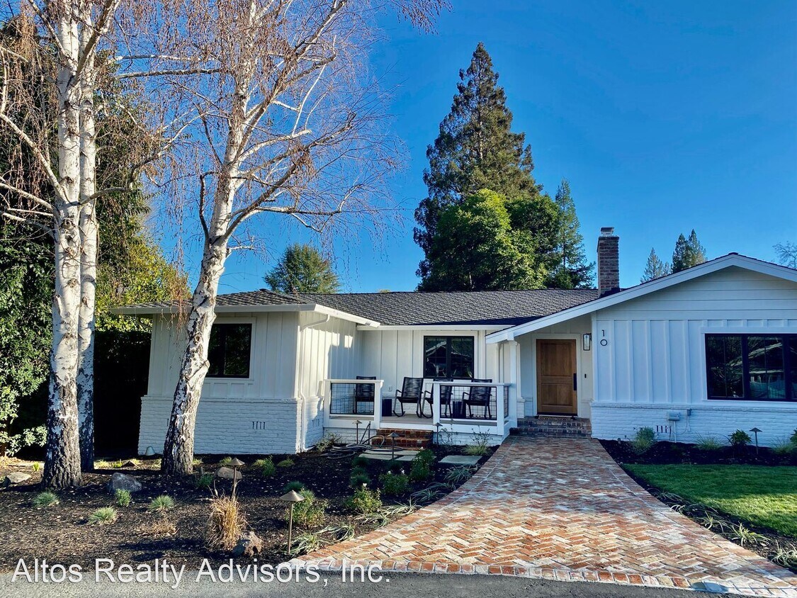
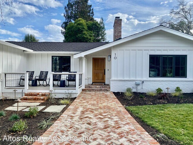
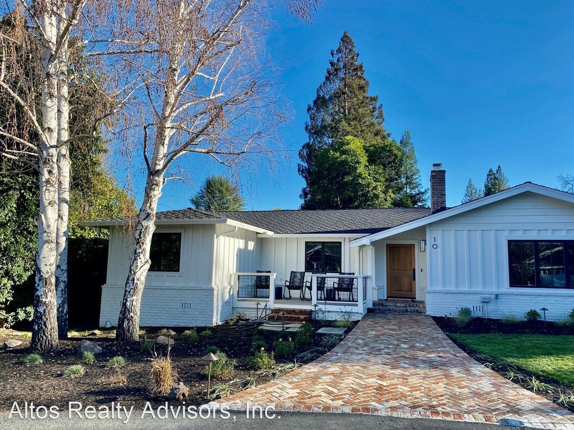
10 Los Alamos Ct
Alamo, CA 94507
2 Weeks Ago
Favorites
10 Los Alamos Ct

Favorites
Check Back Soon for Upcoming Availability
| Beds | Baths | Average SF |
|---|---|---|
| 4 Bedrooms 4 Bedrooms 4 Br | 3.5 Baths 3.5 Baths 3.5 Ba | 3,015 SF |
Fees and Policies
The fees below are based on community-supplied data and may exclude additional fees and utilities.
- Dogs Allowed
-
Fees not specified
-
Weight limit--
-
Pet Limit--
About This Property
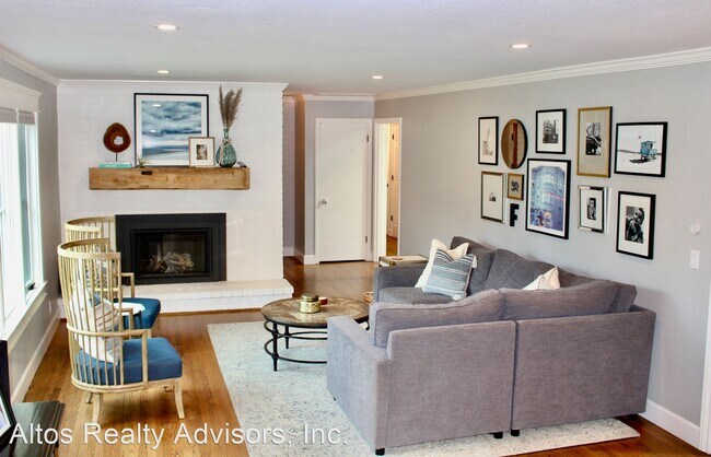
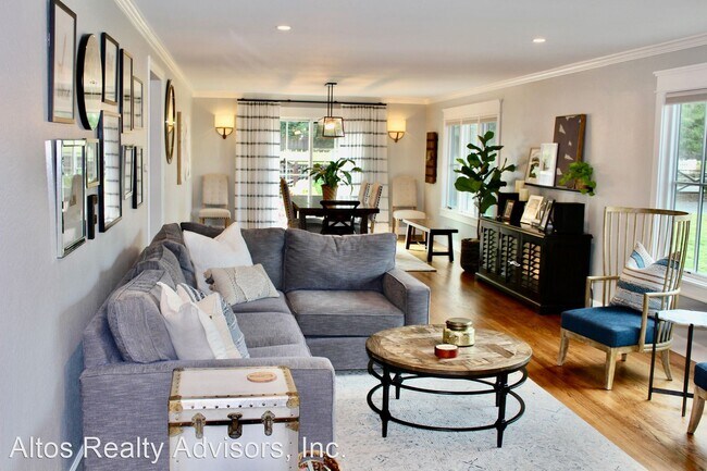
(408) 720-0920 x101 - Recently Updated 4 Bed 3.5 Bath Farmhouse Style Home on 1/2 Acre Westside Alamo - *Courtesy Listing* This recently updated 4 bed 3.5 bath farmhouse style home features 3,015 square feet of living space on a 1/2 acre lot in the highly desirable Westside Alamo neighborhood. Iron Horse Trail access from the cul-de-sac. A short distance to schools, Las Trampas ridge hiking trail and Alamo Shopping Center. -Central Forced Heat & Air Conditioning -Hardwood Floors -Pool -Golf Putting Green -Pool Cabana -75" TV W/ In-Wall Surround Sound -Nest Security System & Doorbell -Nest Thermostats -3-Bed Vegetable Garden W/ Drip System -ADT Alarm -Automatic Shades -Remote Regency Fireplace Insert -Washer & Dryer Included -Open Kitchen Layout -Doors & Windows Replaced in 2021 -Recessed Lighting Throughout -Pool Solar Heating & Electric Solar -2-Car Garage Parking Pets -Negotiable No Smoking. Utilities -Landlord pays for pool service & landscaping services -Tenant responsible for all utilities Schools *Tenants to Verify Enrollment* -Rancho Romero Elementary -Stone Valley Middle -San Ramon Valley High *Home to be delivered unfurnished* (RLNE7194575) Pet policies: Small Dogs Allowed, Cats Allowed, Large Dogs Allowed.
10 Los Alamos Ct is a house located in Contra Costa County and the 94507 ZIP Code. This area is served by the San Ramon Valley Unified attendance zone.
Location
Get Directions
Situated about 25 miles east of San Francisco, Alamo is an upscale suburb in Contra Costa County. Alamo offers residents the best of suburban living—peaceful luxury within close proximity to the bustling and vibrant San Francisco Bay Area. Outdoor recreation abounds near Alamo, with convenience to Mount Diablo State Park, Las Trampas Regional Wilderness, and Redwood Regional Park. Shopping opportunities are plentiful in Alamo’s charming downtown area as well as in neighboring Walnut Creek. Getting around from Alamo is simple with access to I-680 and the Lafayette BART Station.
Learn more about living in Alamo
Education
| Colleges & Universities | Distance | ||
|---|---|---|---|
| Colleges & Universities | Distance | ||
| Drive: | 22 min | 10.8 mi | |
| Drive: | 19 min | 11.1 mi | |
| Drive: | 22 min | 12.4 mi | |
| Drive: | 34 min | 22.2 mi |
10 Los Alamos Ct is within 22 minutes or 10.8 miles from Saint Marys Coll. of Calif.. It is also near Diablo Valley, Pleasant Hill and Diablo Valley Coll, San Ramon.
Schools


Public Elementary School
Grades K-5
497 Students
Nearby
Public Elementary School
Grades K-5
442 Students
Attendance Zone
Public Middle School
Grades 6-8
580 Students
Attendance Zone
Public High School
Grades 9-12
1,981 Students
Attendance Zone
Private Elementary School
Grades PK-6
96 Students
Nearby
Private Elementary & Middle School
Grades K-8
355 Students
Nearby
Private Elementary & Middle School
Grades K-8
631 Students
Nearby
School data provided by
 The GreatSchools Rating helps parents compare schools within a state based on a variety of school quality indicators and provides a helpful picture of how effectively each school serves all of its students. Ratings are on a scale of 1 (below average) to 10 (above average) and can include test scores, college readiness, academic progress, advanced courses, equity, discipline and attendance data. We also advise parents to visit schools, consider other information on school performance and programs, and consider family needs as part of the school selection process.
View GreatSchools Rating Methodology
Data provided by GreatSchools.org © 2025. All rights reserved.
View GreatSchools Rating Methodology
Data provided by GreatSchools.org © 2025. All rights reserved.
Transportation options available in Alamo include Walnut Creek Station, located 6.2 miles from 10 Los Alamos Ct. 10 Los Alamos Ct is near Metro Oakland International, located 28.3 miles or 40 minutes away, and San Francisco International, located 40.3 miles or 58 minutes away.
| Transit / Subway | Distance | ||
|---|---|---|---|
| Transit / Subway | Distance | ||
|
|
Drive: | 11 min | 6.2 mi |
|
|
Drive: | 12 min | 7.8 mi |
|
|
Drive: | 13 min | 8.3 mi |
|
|
Drive: | 18 min | 12.4 mi |
|
|
Drive: | 18 min | 12.4 mi |
| Commuter Rail | Distance | ||
|---|---|---|---|
| Commuter Rail | Distance | ||
|
|
Drive: | 24 min | 17.4 mi |
|
|
Drive: | 33 min | 17.7 mi |
| Drive: | 33 min | 17.7 mi | |
|
|
Drive: | 30 min | 19.7 mi |
|
|
Drive: | 30 min | 21.4 mi |
| Airports | Distance | ||
|---|---|---|---|
| Airports | Distance | ||
|
Metro Oakland International
|
Drive: | 40 min | 28.3 mi |
|
San Francisco International
|
Drive: | 58 min | 40.3 mi |
Time and distance from 10 Los Alamos Ct.
| Shopping Centers | Distance | ||
|---|---|---|---|
| Shopping Centers | Distance | ||
| Walk: | 17 min | 0.9 mi | |
| Drive: | 3 min | 1.2 mi | |
| Drive: | 4 min | 1.2 mi |
10 Los Alamos Ct has 3 shopping centers within 1.2 miles, which is about a 4-minute walk. The miles and minutes will be for the farthest away property.
| Parks and Recreation | Distance | ||
|---|---|---|---|
| Parks and Recreation | Distance | ||
|
Eugene O'Neill National Historic Site
|
Drive: | 9 min | 3.0 mi |
|
Rudgear Park
|
Drive: | 9 min | 3.6 mi |
|
Lar Rieu Park
|
Drive: | 10 min | 5.3 mi |
|
Little Hills Picnic Ranch (By Reservation)
|
Drive: | 27 min | 11.1 mi |
|
Las Trampas Regional Wilderness
|
Drive: | 29 min | 11.6 mi |
10 Los Alamos Ct has 5 parks within 11.6 miles, including Eugene O'Neill National Historic Site, Las Trampas Regional Wilderness, and Rudgear Park.
| Hospitals | Distance | ||
|---|---|---|---|
| Hospitals | Distance | ||
| Drive: | 8 min | 4.6 mi | |
| Drive: | 13 min | 7.3 mi | |
| Drive: | 12 min | 7.5 mi |
10 Los Alamos Ct has 3 hospitals within 7.5 miles, the nearest is Kaiser Foundation Hospital - Walnut Creek which is 4.6 miles away and a 8 minute drive.
You May Also Like
Similar Rentals Nearby


What Are Walk Score®, Transit Score®, and Bike Score® Ratings?
Walk Score® measures the walkability of any address. Transit Score® measures access to public transit. Bike Score® measures the bikeability of any address.
What is a Sound Score Rating?
A Sound Score Rating aggregates noise caused by vehicle traffic, airplane traffic and local sources
10 Los Alamos Ct
Alamo, CA 94507