
$3,800
Total Monthly Price
10 Irving St
Somerville, MA 02144
Favorites
10 Irving St

Favorites
Check Back Soon for Upcoming Availability
| Beds | Baths | Average SF |
|---|---|---|
| 3 Bedrooms 3 Bedrooms 3 Br | 1 Bath 1 Bath 1 Ba | — |
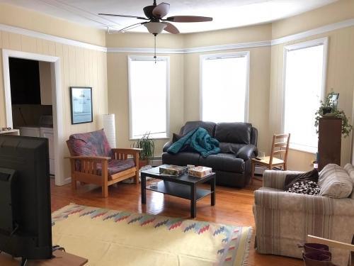
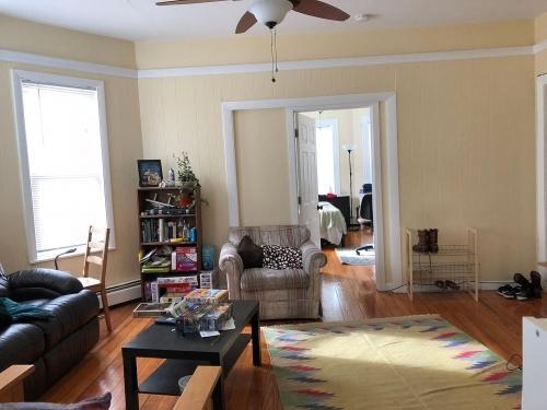
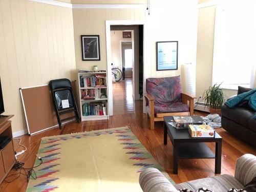
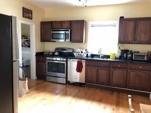
About This Property
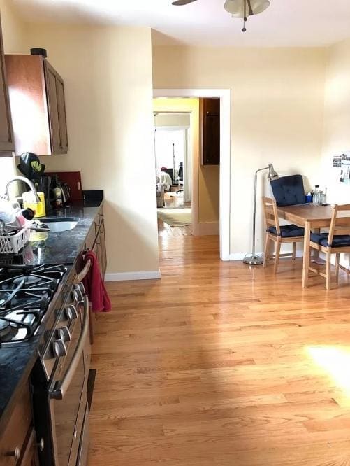
APS52674582 - Please inquire for more information!- 3 bed/1 bath (first floor)- Large eat-in-kitchen- Separate living room- Free use of laundry machines in-unit- Hardwood floors throughout- Shared backyard- Parking for 1 car TANDEM in the shared drivewayBus: 77 North Cambridge Carhouse (0.30 mi)Bus: 87 Holland St @ Wallace St (0.04 mi)Bus: 83 Rindge Ave @ Massachusetts Ave (0.43 mi)Bus: 88 Highland Ave @ Cutter Ave (0.33 mi)Subway: Red Line Davis (0.17 mi)Bus: 96 College Ave @ Chapel St (0.14 mi)Bus: 80 College Ave @ Powder House Sq (0.41 mi)Bus: 89 Broadway @ Simpson Ave (0.21 mi)Bus: 89/93 Broadway @ Mason St (0.21 mi)
10 Irving St is a condo located in Middlesex County and the 02144 ZIP Code. This area is served by the Cambridge School District attendance zone.
10 Irving St,
Somerville,
MA
02144
Nestled in the heart of Greater Boston, Somerville combines historic architecture with contemporary city living. The community features diverse housing options, from traditional triple-deckers to modern apartments, with current rental rates of $3,277 for one-bedroom units and $3,993 for two-bedroom homes. The rental market has seen moderate growth, with one-bedroom rates increasing by 3.9% over the past year.
Somerville's character shines through its distinct squares and neighborhoods. Davis Square pulses with activity around the landmark Somerville Theatre, while Union Square draws visitors to its farmers market and international restaurants. The Somerville Community Path offers residents a tree-lined route for recreation and commuting. The presence of Tufts University adds to the area's educational atmosphere.
Learn more about living in Somerville
Education
| Colleges & Universities | Distance | ||
|---|---|---|---|
| Colleges & Universities | Distance | ||
| Walk: | 13 min | 0.7 mi | |
| Walk: | 19 min | 1.0 mi | |
| Drive: | 3 min | 1.4 mi | |
| Drive: | 4 min | 2.1 mi |
10 Irving St is within 13 minutes or 0.7 mile from Tufts Univ., Medford. It is also near Lesley University, Porter and Lesley University.
Schools


Public Elementary School
Grades PK-5
320 Students
Nearby
Public Middle School
Grades 6-8
278 Students
Nearby
Public High School
Grades 9-12
1,367 Students
Attendance Zone
Private Elementary School
Grades K-6
16 Students
Nearby
Private Elementary, Middle & High School
Grades PK-12
575 Students
Nearby
Private High School
Grades 9-12
344 Students
Nearby
School data provided by
 The GreatSchools Rating helps parents compare schools within a state based on a variety of school quality indicators and provides a helpful picture of how effectively each school serves all of its students. Ratings are on a scale of 1 (below average) to 10 (above average) and can include test scores, college readiness, academic progress, advanced courses, equity, discipline and attendance data. We also advise parents to visit schools, consider other information on school performance and programs, and consider family needs as part of the school selection process.
View GreatSchools Rating Methodology
Data provided by GreatSchools.org © 2026. All rights reserved.
View GreatSchools Rating Methodology
Data provided by GreatSchools.org © 2026. All rights reserved.
Transportation options available in Somerville include Davis Station, located 0.2 mile from 10 Irving St. 10 Irving St is near General Edward Lawrence Logan International, located 8.3 miles or 16 minutes away.
| Transit / Subway | Distance | ||
|---|---|---|---|
| Transit / Subway | Distance | ||
|
|
Walk: | 3 min | 0.2 mi |
|
|
Walk: | 16 min | 0.9 mi |
| Drive: | 3 min | 1.2 mi | |
| Drive: | 3 min | 1.3 mi | |
| Drive: | 3 min | 1.3 mi |
| Commuter Rail | Distance | ||
|---|---|---|---|
| Commuter Rail | Distance | ||
|
|
Drive: | 3 min | 1.4 mi |
|
|
Drive: | 5 min | 2.1 mi |
|
|
Drive: | 7 min | 3.5 mi |
|
|
Drive: | 9 min | 4.2 mi |
| Drive: | 16 min | 8.5 mi |
| Airports | Distance | ||
|---|---|---|---|
| Airports | Distance | ||
|
General Edward Lawrence Logan International
|
Drive: | 16 min | 8.3 mi |
Walkability Near 10 Irving St Somerville, MA 02144
Getting Around
 What do Walkability, Transit, Drivability, and Bikeability mean?
Walkability measures the walking distance to day-to-day needs.
Transit measures access to public transportation.
Drivability measures congestion, parking availability, and access to major roads.
Bikeability measures the suitability for cycling.
How It Works
What do Walkability, Transit, Drivability, and Bikeability mean?
Walkability measures the walking distance to day-to-day needs.
Transit measures access to public transportation.
Drivability measures congestion, parking availability, and access to major roads.
Bikeability measures the suitability for cycling.
How It Works
Exceptionally Walkable
Walkability
90
/ 100
Good Public Transit
Transit
70
/ 100
Fairly Drivable
Drivability
50
/ 100
Very Bikeable
Bikeability
80
/ 100
Scores provided by
-
Soundscore™
-
/ 100
Traffic
-Airport
-Businesses
-Scores provided by
HowLoud What is a Sound Score Rating? A Sound Score Rating aggregates noise caused by vehicle traffic, airplane traffic and local sources. How It WorksTime and distance from 10 Irving St.
| Shopping Centers | Distance | ||
|---|---|---|---|
| Shopping Centers | Distance | ||
| Walk: | 14 min | 0.8 mi | |
| Walk: | 17 min | 0.9 mi | |
| Drive: | 3 min | 1.3 mi |
10 Irving St has 3 shopping centers within 1.3 miles, which is about a 3-minute drive. The miles and minutes will be for the farthest away property.
| Parks and Recreation | Distance | ||
|---|---|---|---|
| Parks and Recreation | Distance | ||
|
Harvard-Smithsonian Center for Astrophysics
|
Drive: | 5 min | 1.7 mi |
|
Mineralogical and Geological Museum
|
Drive: | 4 min | 1.7 mi |
|
Harvard Museum of Natural History
|
Drive: | 4 min | 1.7 mi |
|
Longfellow National Historic Site
|
Drive: | 5 min | 2.2 mi |
|
Mystic River Reservation
|
Drive: | 5 min | 2.2 mi |
10 Irving St has 5 parks within 2.2 miles, including Harvard-Smithsonian Center for Astrophysics, Harvard Museum of Natural History, and Mineralogical and Geological Museum.
| Hospitals | Distance | ||
|---|---|---|---|
| Hospitals | Distance | ||
| Drive: | 6 min | 2.6 mi | |
| Drive: | 6 min | 2.7 mi | |
| Drive: | 11 min | 4.4 mi |
10 Irving St has 3 hospitals within 4.4 miles, the nearest is Cambridge Health Alliance which is 2.6 miles away and a 6 minute drive.
| Military Bases | Distance | ||
|---|---|---|---|
| Military Bases | Distance | ||
| Drive: | 20 min | 10.3 mi | |
| Drive: | 32 min | 17.8 mi | |
| Drive: | 36 min | 18.7 mi |
10 Irving St has 3 military bases within 18.7 miles, the nearest is Hanscom Air Force Base which is 10.3 miles away and a 20 minute drive.
You May Also Like
Similar Rentals Nearby


What Are Walk Score®, Transit Score®, and Bike Score® Ratings?
Walk Score® measures the walkability of any address. Transit Score® measures access to public transit. Bike Score® measures the bikeability of any address.
What is a Sound Score Rating?
A Sound Score Rating aggregates noise caused by vehicle traffic, airplane traffic and local sources.

10 Irving St
Somerville, MA 02144